Nepal turns to SMART’s drones, detection gear after declining two Malaysian rescue offers尼泊尔拒绝了马来西亚的两项救援提议后,转而寻求SMART公司的无人机和探测设备。
PUTRAJAYA, Oct 26 — Malaysia’s third offer to assist Nepal in its search and rescue (SAR) operations for mud flood victims was accepted after two earlier offers were turned...
PUTRAJAYA, Oct 26 — Malaysia’s third offer to assist Nepal in its search and rescue (SAR) operations for mud flood victims was accepted after two earlier offers were turned down, paving the way for the deployment of the Special Malaysia Disaster Assistance and Rescue Team (SMART), equipped with technical expertise and advanced detection equipment.
SMART commander Senior Fire Superintendent 1 Abdul Manaf Che Isa, who led the mission, said Malaysia initially offered to send 50 rescuers, followed by a second offer of 25 personnel with SAR equipment, but Nepal declined both offers because it already had sufficient rescue teams.
He said Nepal’s government eventually accepted Malaysia’s third offer, which involved deploying just 11 SMART personnel, nine high-capacity drones and specialised detection equipment, after several rounds of discussions.
“Our initial offer was to deploy 50 personnel for SAR operations, but Nepal had already deployed its own rescue teams and declined the offer. The Nepalese government needed specialised equipment and expertise that it lacked.
“At the same time, we did not want to travel there only to find that there was no work for us to do,” he said in a recent interview with Bernama on SMART’s humanitarian mission in Nepal.
According to Abdul Manaf, Nepal declined the first two offers not because it did not need Malaysia’s assistance, but because it had already mobilised enough rescuers, including members of the military, police and fire services, volunteers, and international SAR teams from countries including China and South Korea.
He said SMART’s strengths included high-capacity drones for aerial surveys, mapping disaster-hit areas and locating victims, as well as specialised equipment capable of detecting sounds and movement beneath mud deposits.
“Buildings may be buried beneath mud while their structures remain intact. The area may look clear from above, but this equipment enables us to detect sounds and movement. Such equipment was not available there, and the authorities saw the need for it,” he said.
Abdul Manaf said diplomatic engagement through the Malaysian Embassy in Kathmandu also played a key role in convincing the Nepalese military that SMART could provide the technical assistance needed, including SAR detection equipment, search cameras, satellite phones and specialised communication systems.
He said the Nepalese government prioritised self-sufficient international relief teams, a criterion that aligned with SMART’s capabilities recognised by the International Search and Rescue Advisory Group (INSARAG), as disaster victims need local shelter, food supplies and logistical support.
Once Nepal’s government had approved the mission, the SMART team was deployed to the Nepalese military’s tactical base in Trishuli, from where it took a helicopter to reach search areas no longer accessible by road because of infrastructure damage.
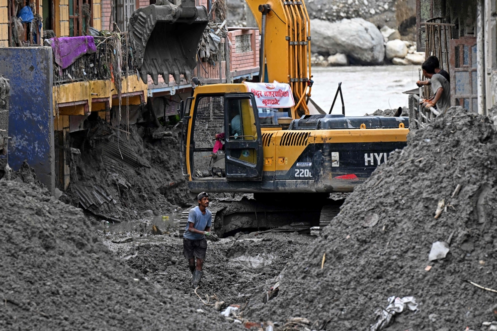
Abdul Manaf said the mud floods had drastically altered the terrain, making existing maps unreliable and forcing SMART personnel to use drones, GPS, and physical observations to determine search routes.
“For ground operations, we could not rely fully on maps as the terrain had changed significantly from what they depicted. Roads and buildings had been destroyed, leaving only rocks, sand and mud,” he said, noting that mud deposits reached depths of three to five metres, and up to eight metres in some areas.
He said heavy rain and overcast conditions also hampered helicopter operations, forcing personnel to be dropped off on hillsides before walking for more than an hour to reach the operation site, while also facing the risk of further disasters.
He said SMART personnel spent three days conducting secondary searches with Nepalese military tactical teams in designated sectors between Timure and Syabrubesi, using their expertise and specialised equipment to search the last known location of the Malaysians reported missing, but found no survivors.
SMART also shared aerial images and drone footage with the families concerned and handed over equipment and supplies to the Nepalese military to support continued search operations.
Abdul Manaf stressed that the SMART team had searched as extensively as possible amid difficult geographical, weather and safety conditions, adding that SAR operations focused first on rescuing survivors, with recovery efforts undertaken if necessary.
He also appealed to the families to remain resilient and patient while awaiting further steps by the Malaysian and Nepalese governments through coordination by the Foreign Ministry. — Bernama
Abang Johari confirms AI data centre plan in Sarawak under US$50b investment
Live pig imports from Sarawak to Selangor subject to strict controls since July 2025, says deputy minister
Court of Appeal slashes Klang council’s RM117m dumpsite damages bill to RM3m
布城,10 月 26 日讯——马来西亚第三次提出协助尼泊尔搜救泥石流灾民,此前两次遭到拒绝,此次终于获得尼泊尔的接受,为部署配备技术专长和先进探测设备的马来西亚特别灾害援助和救援队(SMART)铺平了道路。
SMART 指挥官、高级消防总监 1 Abdul Manaf Che Isa 领导了此次救援任务,他表示,马来西亚最初提出派遣 50 名救援人员,随后又提出派遣 25 名人员携带搜救设备,但尼泊尔拒绝了这两项提议,因为它已经拥有足够的救援队。
他说,经过几轮磋商,尼泊尔政府最终接受了马来西亚的第三项提议,即仅部署 11 名 SMART 人员、9 架高容量无人机和专用探测设备。
“我们最初提议派遣50名人员参与搜救行动,但尼泊尔已经部署了自己的救援队,拒绝了我们的提议。尼泊尔政府需要他们所缺乏的专用设备和专业技术。”
“与此同时,我们也不想到了那里却发现没有工作可做,”他在最近接受马来西亚国家通讯社(Bernama)采访时谈到SMART在尼泊尔的人道主义任务时说道。
据阿卜杜勒·马纳夫称,尼泊尔拒绝了前两次援助提议,并非因为尼泊尔不需要马来西亚的援助,而是因为尼泊尔已经动员了足够的救援人员,包括军人、警察和消防员、志愿者以及来自中国和韩国等国的国际搜救队。
他表示,SMART 的优势包括用于空中勘测、绘制灾区地图和定位受害者的高容量无人机,以及能够探测泥层下声音和运动的专用设备。
他说:“建筑物可能被泥浆掩埋,但其结构仍然完好无损。从空中俯瞰,该区域可能看起来空无一物,但这套设备使我们能够探测到声音和动静。当地之前没有这样的设备,当局意识到了它的必要性。”
阿卜杜勒·马纳夫表示,通过马来西亚驻加德满都大使馆进行的外交接触也发挥了关键作用,使尼泊尔军方相信SMART能够提供所需的技术援助,包括SAR探测设备、搜索摄像机、卫星电话和专用通信系统。
他表示,尼泊尔政府优先考虑能够自给自足的国际救援队,这一标准与 SMART 的能力相符,并得到了国际搜救咨询小组 (INSARAG) 的认可,因为灾民需要当地的住所、食物供应和后勤支持。
尼泊尔政府批准该任务后,SMART 小组被部署到尼泊尔军队位于特里苏里的战术基地,然后从那里乘坐直升机到达因基础设施遭到破坏而无法通过公路到达的搜索区域。
阿卜杜勒·马纳夫表示,泥石流极大地改变了地形,使得现有的地图不再可靠,迫使 SMART 人员使用无人机、GPS 和实地观察来确定搜索路线。
“由于地形与地图所示存在显著差异,地面作战无法完全依赖地图。道路和建筑物已被摧毁,只剩下岩石、沙子和泥浆,”他说道,并指出泥浆沉积深度达三至五米,在某些地区甚至高达八米。
他表示,暴雨和阴天也阻碍了直升机作业,迫使人员被送到山坡上,然后步行一个多小时才能到达作业地点,同时还面临着发生进一步灾害的风险。
他说,SMART人员与尼泊尔军事战术小组在蒂穆雷和夏布鲁贝西之间的指定区域进行了三天的二次搜索,利用他们的专业知识和专用设备搜索了据报道失踪的马来西亚人的最后已知位置,但没有找到幸存者。
SMART 还与相关家庭分享了航拍图像和无人机拍摄的视频,并向尼泊尔军方移交了设备和物资,以支持继续开展搜救行动。
阿卜杜勒·马纳夫强调,尽管地理、天气和安全条件十分困难,SMART 团队仍尽最大努力进行了广泛搜索。他还补充说,搜救行动首先侧重于营救幸存者,如有必要,才会进行遗体打捞工作。
他还呼吁遇难者家属保持坚韧和耐心,等待马来西亚和尼泊尔政府通过外交部协调采取进一步措施。——马新社
阿邦佐哈里确认砂拉越人工智能数据中心计划投资 500 亿美元
副部长表示,自2025年7月起,从砂拉越进口活猪到雪兰莪将受到严格管制。
上诉法院将巴生市议会1.17亿令吉的垃圾填埋场损害赔偿金削减至300万令吉。