Mount Semeru fires spreading as East Java experiences extreme drought东爪哇遭遇极端干旱,塞梅鲁火山火灾蔓延
JAKARTA: Forest fires around Mount Semeru in Lumajang regency, East Java, have burned 598 hectares on Monday (Aug 31), with two main fires in Senduro district.
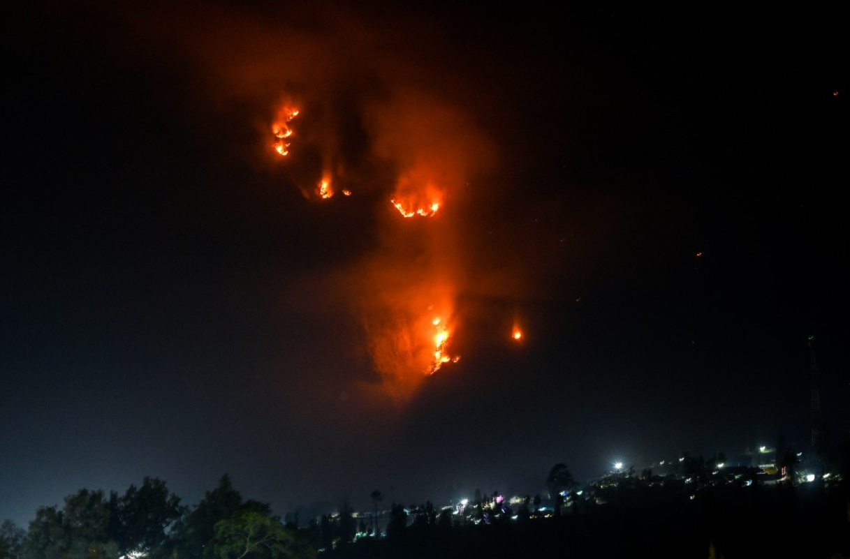
Wildfire flames and smoke rising above a forest on Aug 10 in the Bromo Tengger Semeru National Park near Mount Bromo in Probolinggo, East Java. - AFP
JAKARTA: Forest fires around Mount Semeru in Lumajang regency, East Java, have burned 598 hectares on Monday (Aug 31), with two main fires in Senduro district.
East Java Disaster Mitigation Agency (BPBD) executive director Gatot Soebroto said the affected areas were around Mount Kepolo, Jambangan area, Po’o forest and the Ayak-ayak alternative climbing route.
“Currently, there are two fire spots, in Argosari village’s B29 area and Ranu Pani’s Ranu Kembang area in Senduro district,” he said.
A joint team consisting of personnel from BPBD, the Indonesian Military (TNI), National Police, volunteers and locals tried to limit the fire from spreading by creating firebreaks in Ayak-ayak and Po’o. Fire dousing efforts were also conducted along the Semeru climbing route between Post 1 and Post 2 to control fire spots and prevent fire from spreading to other areas.
Gatot said that difficult terrain was the biggest challenge.
“Fire locations are in cliffs which are very steep and the wind is blowing strongly causing fire to spread quickly,” he said.
Bromo Tengger Semeru National Park (TNBTS) management closed all climbing activities on 3,676-metre Mount Semeru on Aug 26 for an indefinite time for climbers’ safety and to support forest fire handling.
“East Java BPBD and Lumajang BPBD are coordinating with TNBTS to expedite forest fire handling,” Gatot said.
The fires were exacerbated by extreme weather in East Java with the Meteorology, Climatology and Geophysics Agency’s (BMKG) East Java Climatology Station issuing a warning on meteorological drought on Monday.
Observations showed that most East Java experienced more than 60 consecutive days without rain, the threshold for extreme drought. Rain distribution on Aug 21-31 was low and BMKG forecasted that dry conditions will continue until Sept 10 with a possibility of more than 90 per cent.
“This condition may increase drought risks in agricultural lands, reduce raw water availability and trigger forest and fire fires,” BMKG said in the warning.
Semeru forest fires were first reported on Aug 26 at about 8pm. The fires were initially detected in Ranu Kembang, west of Post 4 of the Semeru climbing route in Ranu Pani village. The central government also took anticipatory measures by closing temporarily all climbing activities in nine national parks which have high vulnerability of forest fires.
Forestry Minister Raja Juli Antoni said on Monday that the policy was taken to reduce safety risks for climbers and maximize resources to handle forest fires in six priority provinces.
“There will be an official circular from the Natural Resources and Ecosystem Conservation director general,” he said after participating at a coordination meeting on forest fires in Palembang.
“But I can announce the temporary closures of nine national parks.”
Raja Juli said the closure was not to limit the public’s enthusiasm but for safety. He pointed to an incident in Bromo Tengger Semeru National Park when 170 climbers were trapped by forest fires. He said that forest fires in national parks presented difficulties in fire extinguisher operations.
“Helicopters which should be focused to conduct water bombings in six priority provinces must be diverted to national parks,” he said.
“But because there are extraordinary fires in national parks, the helicopters are also deployed to the national parks.”
The closed national parks are Semeru trail in Bromo Tengger Semeru, Bukit Baka Bukit Raya, Kerinci Seblat, Mount Ciremai, Tambora, Manusela, Mount Gede Pangrango, Leuser and Lorentz. Meanwhile, national parks still open with strict supervision are Mount Rinjani, Mount Merbabu, Mount Halimun Salak and Hyang Plateau Wildlife Sanctuary. - The Jakarta Post/ANN
Thank you for your report!
Indonesia allows limited tourism at Mt Rinjani amid wildfire risk
Two crew members killed after vessel catches fire off Indonesia's southeast Sulawesi
Eruption of Sinabung volcano on Indonesia’s Sumatra island prompts higher alert
8月10日,东爪哇省普罗博林戈市布罗莫-腾格尔-塞梅鲁国家公园布罗莫火山附近,野火熊熊燃烧,浓烟滚滚升腾。——法新社
雅加达:截至周一(8月31日),东爪哇省卢马江县塞梅鲁山周围的森林火灾已烧毁598公顷土地,其中森杜罗区有两处主要火灾。
东爪哇减灾署(BPBD)执行主任加托·苏布罗托表示,受灾地区包括克波罗山周边、詹邦安地区、波奥森林和阿亚克阿亚克替代登山路线。
他说:“目前,森杜罗区阿尔戈萨里村的 B29 地区和拉努帕尼的拉努肯邦地区有两个火灾点。”
由印尼国家灾害管理局(BPBD)、印尼军队(TNI)、国家警察、志愿者和当地居民组成的联合小组,在阿亚克亚克(Ayak-ayak)和波奥(Po'o)地区设置防火隔离带,试图阻止火势蔓延。此外,他们还在塞梅鲁火山1号哨所和2号哨所之间的登山路线上进行了灭火作业,以控制火点并防止火势蔓延到其他区域。
加托表示,崎岖的地形是最大的挑战。
他说:“火灾地点位于非常陡峭的悬崖上,而且风力强劲,导致火势迅速蔓延。”
布罗莫腾格尔塞梅鲁国家公园(TNBTS)管理部门于 8 月 26 日关闭了海拔 3,676 米的塞梅鲁火山的所有登山活动,无限期暂停,以保障登山者的安全和支持森林火灾的处理。
“东爪哇省森林火灾预防局和卢马姜省森林火灾预防局正在与国家森林火灾防治中心协调,以加快森林火灾的处理速度,”加托说。
东爪哇的极端天气加剧了火灾,气象、气候和地球物理局(BMKG)东爪哇气候站周一发布了气象干旱预警。
观测数据显示,东爪哇大部分地区连续60多天无降雨,达到极端干旱的标准。8月21日至31日降雨量偏低,印尼气象、气候和地球物理局(BMKG)预测,干旱状况将持续到9月10日,降雨概率超过90%。
印尼气象、气候和地球物理局 (BMKG) 在警告中表示:“这种情况可能会增加农业用地干旱风险,减少原水供应,并引发森林火灾。”
塞梅鲁山森林火灾最早于8月26日晚8点左右被发现。火灾最初在拉努帕尼村塞梅鲁登山路线4号哨所以西的拉努肯邦地区被发现。中央政府也采取了预防措施,暂时关闭了九个森林火灾高发国家公园的所有登山活动。
林业部长拉贾·朱利·安东尼周一表示,采取这项政策是为了降低登山者的安全风险,并最大限度地利用资源来应对六个重点省份的森林火灾。
“自然资源和生态系统保护总局局长将会发布正式通告,”他在参加完巨港森林火灾协调会议后说道。
“但我可以宣布暂时关闭九个国家公园。”
拉贾·朱利表示,关闭公园并非为了限制公众的热情,而是为了安全。他指出,布罗莫-腾格尔-塞梅鲁国家公园曾发生过一起森林火灾,导致170名登山者被困。他表示,国家公园内的森林火灾会给灭火作业带来诸多困难。
他说:“原本应该集中用于在六个重点省份进行洒水灭火的直升机必须调往国家公园。”
“但由于国家公园内发生了非同寻常的火灾,直升机也被部署到国家公园。”
关闭的国家公园包括Bromo Tengger Semeru的Semeru步道、Bukit Baka Bukit Raya、Kerinci Seblat、Mount Ciremai、Tambora、Manusela、Mount Gede Pangrango、Leuser和Lorentz。与此同时,仍在严格监管下开放的国家公园有林贾尼山(Mount Rinjani)、梅尔巴布山(Mount Merbabu)、哈利蒙萨拉克山(Mount Halimun Salak)和香高原野生动物保护区(Hyang Plateau Wildlife Sanctuary)。 - 雅加达邮报/ANN
感谢您的报告!
尽管面临山火风险,印尼仍允许有限度地游览林贾尼火山。
一艘船只在印度尼西亚东南部苏拉威西岛附近海域起火,造成两名船员死亡。
印尼苏门答腊岛锡纳朋火山喷发,引发更高警戒级别