Relief from heat could come only end-October as strong El Nino extends dry season: Met service气象部门表示,由于强厄尔尼诺现象延长了旱季,高温天气可能要到10月底才能缓解。
The super El Nino is delaying Singapore’s dry season end, with relief from heat and haze expected only by late October or early November. Read more at straitstimes.com.
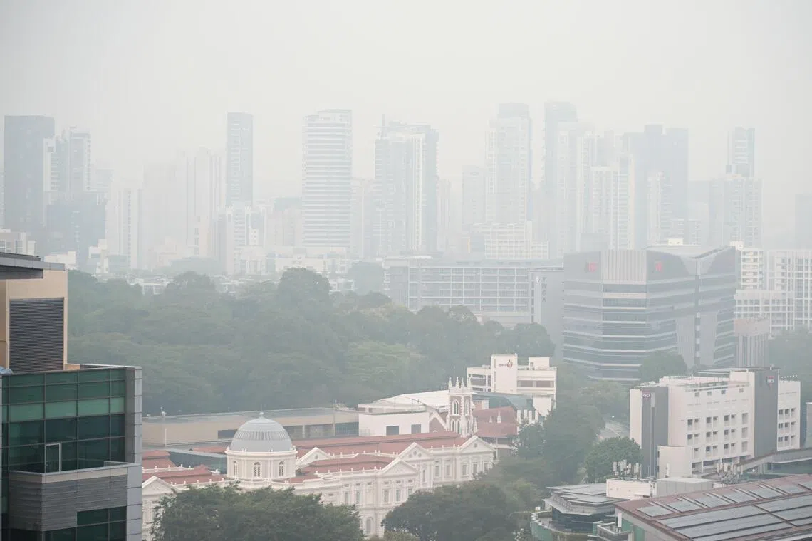
The haze as seen from Middle Road at 7.15am on Sept 30.
ST PHOTO: KUA CHEE SIONG
Published Oct 02, 2026, 10:00 AM
Updated Oct 02, 2026, 10:00 AM
The dry season and haze risk in Singapore may last until early November due to the intense "super El Nino" climate event contributing to hotter, drier weather and Indonesia’s severe wildfires.
Monsoon rains expected to arrive around December should help reduce haze and fires.
However, the wet phase relief could be short and weaker, with warmer, drier, and hazy conditions possibly returning in 2027 during the monsoon’s dry phase.
SINGAPORE – Reprieve from the heat in Singapore is likely to come only in late October or early November, as the super El Nino weather phenomenon delays the retreat of the dry season.
The Meteorological Service Singapore (MSS) said this in response to The Straits Times’ queries on whether the expected end of the dry season, which usually stretches between June and September, could bring more rain over the country.
“El Nino events, particularly strong ones, tend to delay the retreat of the dry season for much of southern ASEAN region,” said the spokesperson for the MSS under the National Environment Agency.
“For the event this year, we are predicting transition during late October or early November for Singapore, later than in the previous two years.”
The dry south-west monsoon season usually tapers off by September, and the start of the rainy north-east monsoon season tends to set in around late November.
The El Nino event in 2026 – termed a “super El Nino” or “Godzilla” El Nino – has worsened the usual dry season experienced in equatorial South-east Asian countries, including Singapore, Malaysia and Indonesia .
This has contributed to Indonesia’s most intense wildfires in 11 years . Winds blowing from the south bring the smoke to Singapore, taking air quality over the Republic to unhealthy levels in September.
El Nino events tend to reduce cloud cover from October to November, bringing less rainfall and increasing surface temperatures over that period, said Koh Tieh Yong, a meteorologist from the World Climate Research Programme’s Working Group on Asia-Australia Monsoon.
El Nino’s influence on rainfall and temperature
The three strongest El Nino events since 1980 happened in 1982/1983, 1997/1998 and 2015/2016.
The impacts of a single El Nino event tend to spill over two years.
MSS data showed that the El Nino events can affect rainfall and temperature during the October-to-November period.
For instance, the long-term average rainfall from 1991 to 2020 for these months is about 490.7mm of rain.
This figure drops during strong El Nino events: The average rainfall for those two months was 450.5mm in 1982, 275.3mm in 1997 and 351mm in 2015.
Similarly, the long-term average temperature for these two months was 27.6 deg C. In 1982, the average temperature for these months was 26.8 deg C; in 1997, it was 28 deg C; and in 2015, 28.3 deg C.
“More recent El Nino events also tend to be warmer than those occurring more than 30 years ago due global warming,” said the MSS spokesperson. “1982’s temperatures were mostly below this average, illustrating the effect of the long-term warming trend.”
She added that El Nino tends to have a stronger influence on rainfall and temperature around the February to March period.
For instance, the long-term average rainfall for those two months is 345.9mm. This dropped to 64.1mm in 1983, 138.9mm in 1998 and 263.5mm in 2016.
In terms of temperature, the long-term average for February and March is 27.6 deg C. During the 1983 El Nino year, the average temperature for the period was 27.8 deg C. In 1998, it was 29.2 deg C, and 28.4 deg C in 2016.
True relief from haze could only come later in the year, when monsoon rains reach Indonesia in late December or early January, said Koh, who is also an adjunct associate professor at the National University of Singapore.
These rainfall events are expected to greatly help to contain and put out the haze-inducing fires, he said.
Wang Jingyu, a weather expert and assistant professor at the National Institute of Education, agreed that the wetter weather will help clear the air.
However, he warned that under a strong El Nino, the respite could be weaker and shorter than normal.
“El Nino suppresses cold surges and rainfall, and the monsoon’s own dry phase from late January to March returns quickly,” said Wang.
The north-east monsoon season brings rainier weather over Singapore between November and January, but then has a drier period from February to March.
Said Wang: “So expect a brief improvement around December, followed by a return to warmer, drier and potentially hazy conditions in the latter half of the monsoon.”
Ang Qing is a journalist covering local and international breaking news at The Straits Times, with a focus on the environment, crime, technology and social issues.
9月30日上午7点15分,从中路看到的雾霾。
《海峡时报》摄影:郭志雄
发布于2026年10月2日上午10:00
更新于2026年10月2日上午10:00
由于强烈的“超级厄尔尼诺”气候事件导致新加坡天气更加炎热干燥,加上印尼严重的森林火灾,新加坡的旱季和雾霾风险可能会持续到11月初。
预计12月左右到来的季风降雨将有助于减少雾霾和火灾。
然而,湿润阶段的缓解可能短暂且强度较弱,2027 年季风干旱阶段可能会再次出现更温暖、更干燥、更雾霾的天气。
新加坡——由于超级厄尔尼诺现象延缓了旱季的结束,新加坡的酷暑可能要到10月下旬或11月初才能缓解。
新加坡气象局 (MSS) 在回应《海峡时报》关于旱季(通常从六月持续到九月)预计结束是否会给该国带来更多降雨的询问时表示。
“厄尔尼诺现象,特别是强烈的厄尔尼诺现象,往往会延缓东盟南部大部分地区旱季的消退,”国家环境局下属气象服务部门的发言人表示。
“今年,我们预测新加坡的过渡期将在10月下旬或11月初,比前两年要晚。”
干燥的西南季风季节通常在9月份逐渐减弱,而多雨的东北季风季节则往往在11月下旬左右开始。
2026 年的厄尔尼诺现象——被称为“超级厄尔尼诺”或“哥斯拉”厄尔尼诺——加剧了包括新加坡、马来西亚和印度尼西亚在内的赤道东南亚国家通常经历的旱季。
这导致了印尼11年来最严重的森林火灾。来自南方的风将烟雾带到新加坡,导致新加坡9月份的空气质量达到不健康水平。
世界气候研究计划亚洲-澳大利亚季风工作组的气象学家许铁勇表示,厄尔尼诺现象往往会减少10月至11月的云量,导致降雨量减少,地表温度升高。
厄尔尼诺现象对降雨量和气温的影响
自 1980 年以来最强的三次厄尔尼诺现象分别发生在 1982/1983 年、1997/1998 年和 2015/2016 年。
单次厄尔尼诺现象的影响往往会持续两年之久。
MSS 数据显示,厄尔尼诺现象会影响 10 月至 11 月期间的降雨量和气温。
例如,1991 年至 2020 年这几个月的长期平均降雨量约为 490.7 毫米。
在强厄尔尼诺事件期间,这一数字会下降:1982 年这两个月的平均降雨量为 450.5 毫米,1997 年为 275.3 毫米,2015 年为 351 毫米。
同样,这两个月的长期平均气温为 27.6 摄氏度。1982 年,这两个月的平均气温为 26.8 摄氏度;1997 年为 28 摄氏度;2015 年为 28.3 摄氏度。
“由于全球变暖,近期发生的厄尔尼诺现象往往比30多年前的厄尔尼诺现象温度更高,”气象局发言人表示。“1982年的气温大多低于这一平均水平,这体现了长期变暖趋势的影响。”
她补充说,厄尔尼诺现象往往在二月到三月期间对降雨量和气温产生更显著的影响。
例如,这两个月的长期平均降雨量为 345.9 毫米。1983 年降至 64.1 毫米,1998 年降至 138.9 毫米,2016 年降至 263.5 毫米。
就气温而言,二月和三月的长期平均气温为 27.6 摄氏度。在 1983 年厄尔尼诺现象期间,该时期的平均气温为 27.8 摄氏度。1998 年为 29.2 摄氏度,2016 年为 28.4 摄氏度。
Koh表示,真正的雾霾缓解可能要等到今年晚些时候,也就是季风雨在12月下旬或1月初抵达印度尼西亚的时候。Koh同时也是新加坡国立大学的兼职副教授。
他表示,这些降雨预计将极大地帮助控制和扑灭引发烟雾的火灾。
气象专家、国立教育研究院助理教授王景宇也认为,降雨增多有助于净化空气。
但他警告说,在强厄尔尼诺现象的影响下,这种缓解期可能会比正常情况更弱、更短暂。
王说:“厄尔尼诺现象抑制了冷空气和降雨,季风自身从1月下旬到3月的干旱期也会很快恢复。”
东北季风季节在11月至1月期间给新加坡带来较多雨水,但在2月至3月期间则较为干燥。
王先生说:“因此,预计12月前后天气会有短暂好转,随后季风后期天气将再次转暖、干燥,并可能出现雾霾。”
Ang Qing是《海峡时报》的一名记者,负责报道本地和国际突发新闻,重点关注环境、犯罪、科技和社会问题。