China-Nepal floods: First research shows that no one could have outrun debris flow中尼洪灾:初步研究表明,无人能够躲过泥石流
First Chinese study of the disaster shows debris reached speeds of 19 metres per second when it struck a border crossing in Tibet
新闻视频
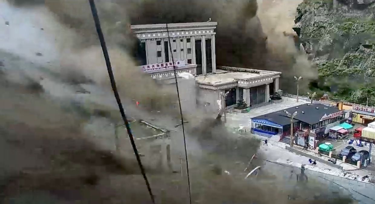
Not even the world’s fastest sprinters could have outrun the devastating floodwaters that struck a border crossing between China and Nepal last week, according to one of the first peer-reviewed assessments of the disaster.
Researchers from the Chinese Academy of Sciences (CAS) calculated that the surface velocity of the debris flow was 19 metres per second (62 feet per second) when it struck the checkpoint at Gyirong Port in Tibet .
This is almost twice Usain Bolt’s average speed when he set the 100 metres world record of 9.58 seconds in 2009, and 50 per cent higher than his top speed.
In a paper posted online on Tuesday by the Chinese-language journal Yangtze River, the team used digital models and frame-by-frame analysis to reconstruct the event, which was triggered by the collapse of a high-altitude glacier in Nepal .
“This disaster involved a continuous transition from ice avalanche to debris flow, then to mudslide and finally to flood,” wrote the team from CAS Institute of Mountain Hazards and Environment.
“The time from the occurrence of the ice avalanche to its impact on the Gyirong Port was extremely short, and the effective response time was limited, which put forward higher requirements for rapid identification, information transmission and emergency decision-making.”
The collapse of the glacier in Langtang Lirung on the Nepalese side of the Himalayan border created an ice-rock avalanche and debris flow that quickly reached Gyirong Port, almost 22km (14 miles) away, and then continued to cascade downstream.
The floods killed at least 16 people in China, while another 546 are still missing. In Nepal the death toll has risen to 1,058 with 4,606 people still missing.
The researchers calculated that the floods still had a surface velocity of around 11.7 metres per second by the time they reached a bridge on Nepal’s Trishuli River 52km away from the border crossing.
This meant that it took between 46 and 75 minutes for the flow to reach the bridge, “providing a potential time window for downstream disaster response”.
But the team said this was not the same as an actual warning time because factors such as monitoring, communications and the ability to respond all came into play.
The Nepalese authorities have criticised the Chinese government for failing to provide timely warnings once the flow had crossed the border.
The floods and other similar events have shown how difficult it is to detect and monitor high-altitude ice avalanches.
The Chinese researchers concluded that a feasible response to such incidents could include tracking the potential route of the resulting ice flows and ensuring warnings are issued as soon as possible.
This could be done by moving monitoring points further upstream and by using multiple sources such as remote sensing, water level monitoring and seismic data.
The team also said such avalanches could create temporary dams in narrow valleys – and although these created further risks, they could also buy more time for evacuations and emergency response efforts.
Some media reports have said that Chinese researchers had warned of a flood risk in this region a year ago, pointing to research published online in July last year just days after a bridge at the border crossing was destroyed when the natural dam holding back a glacial lake collapsed.
Scientists from the Chengdu University of Technology looked at how glacial lakes were rising as a result of climate change and said there was a risk of further incidents upstream from the bridge.
Although the research called for better early warning systems for upstream floods, it did not examine the potential for a glacier collapse.
The CAS researchers said that while climate change would have an effect on the stability of glaciers and other ice formations, it was not the only factor.
The team also said further research was needed on ways to improve disaster detection and early warnings.
They also warned there was some uncertainty about their research because it had relied on limited data and estimates rather than direct measurements and field verification.
In a second study published on Tuesday in the CAS-run journal Science Bulletin, another team described the catastrophe as a sudden failure driven by long-term glacier dynamics rather than an immediate trigger such as heavy rainfall.
The researchers from institutes in mainland China and Hong Kong also found that seismic precursor signals hours before the collapse coincided with smaller-scale snow and ice activity witnessed on-site. -- SOUTH CHINA MORNING POST
Thank you for your report!
Trump says China is driving anger at US data centres. These residents disagree, reports SCMP
SMG, SCMP ink MOU aimed at strengthening business ties between M'sia, Hong Kong
SMG and SCMP ink landmark deal
根据首批经过同行评审的灾害评估报告之一,即使是世界上速度最快的短跑运动员也无法逃脱上周袭击中国和尼泊尔边境口岸的毁灭性洪水。
中国科学院的研究人员计算得出,泥石流撞击西藏吉隆口岸检查站时的表面速度为每秒 19 米(每秒 62 英尺)。
这几乎是尤塞恩·博尔特在 2009 年创造 100 米世界纪录 9.58 秒时的平均速度的两倍,比他的最高速度高出 50%。
在周二发表于中文期刊《长江》上的一篇论文中,该团队利用数字模型和逐帧分析重建了这一事件,该事件是由尼泊尔高海拔冰川崩塌引发的。
“这场灾难经历了从冰崩到泥石流,再到泥石流,最后到洪水的连续转变,”中国科学院山地灾害与环境研究所的研究团队写道。
“从冰崩发生到对吉隆港造成影响的时间非常短,有效反应时间有限,这对快速识别、信息传递和应急决策提出了更高的要求。”
喜马拉雅山脉尼泊尔一侧朗唐里隆冰川的崩塌引发了冰岩雪崩和泥石流,迅速到达近 22 公里(14 英里)外的吉隆港,然后继续向下游倾泻而下。
洪水在中国已造成至少16人死亡,另有546人失踪。在尼泊尔,死亡人数已上升至1058人,仍有4606人失踪。
研究人员计算得出,洪水到达距离边境口岸 52 公里的尼泊尔特里苏里河上的一座桥时,其表面流速仍然约为每秒 11.7 米。
这意味着水流需要 46 到 75 分钟才能到达桥梁,“为下游灾害应对提供了潜在的时间窗口”。
但该团队表示,这与实际的预警时间并不相同,因为监测、沟通和应对能力等因素都会发挥作用。
尼泊尔当局批评中国政府在难民潮越过边境后未能及时发出警告。
洪水和其他类似事件表明,探测和监测高海拔冰崩是多么困难。
中国研究人员得出结论,应对此类事件的可行措施包括追踪由此产生的冰流的潜在路径,并确保尽快发出警告。
这可以通过将监测点向上游移动,并利用遥感、水位监测和地震数据等多种数据源来实现。
该团队还表示,此类雪崩可能会在狭窄的山谷中形成临时堤坝——虽然这会造成进一步的风险,但也可能为疏散和应急响应工作争取更多时间。
一些媒体报道称,中国研究人员一年前就曾警告过该地区存在洪水风险,并指出去年 7 月在网上发表了一项研究,就在几天前,边境口岸的一座桥梁被摧毁,原因是阻挡冰川湖的天然堤坝坍塌。
成都理工大学的科学家们研究了气候变化导致冰川湖水位上升的情况,并表示大桥上游存在发生更多类似事件的风险。
虽然该研究呼吁建立更好的上游洪水预警系统,但并未研究冰川崩塌的可能性。
CAS 的研究人员表示,虽然气候变化会对冰川和其他冰体的稳定性产生影响,但这并非唯一因素。
该团队还表示,需要进一步研究如何改进灾害检测和预警。
他们还警告说,由于他们的研究依赖于有限的数据和估计,而不是直接测量和实地验证,因此存在一些不确定性。
在周二发表于中国科学院旗下期刊《科学公报》上的第二项研究中,另一个研究团队将这场灾难描述为由长期冰川动力学驱动的突然崩溃,而不是由暴雨等直接触发因素造成的。
来自中国大陆和香港科研机构的研究人员还发现,坍塌发生前数小时出现的地震前兆信号与现场观测到的小规模冰雪活动相吻合。——《南华早报》
感谢您的报告!
特朗普称中国煽动民众对美国数据中心的愤怒。据《南华早报》报道,当地居民对此表示反对。
SMG与SCMP签署谅解备忘录,旨在加强马来西亚与香港之间的商业联系
SMG和SCMP签署里程碑式协议