Two new islands appear in Indonesia after major Anak Krakatau eruption阿纳克喀拉喀托火山大喷发后,印度尼西亚出现了两个新岛屿
JAKARTA, Oct 2 — Two new islands have emerged in waters surrounding Mount Anak Krakatau following a major eruption last month that grounded flights for days, the head of...
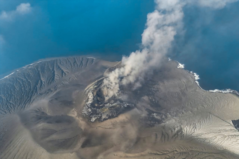
Following a significant eruption last month, two new islands have been identified near Mount Anak Krakatau in the Sunda Strait, as observed via satellite imagery by Indonesia's volcano monitoring agency.
The islands, located northwest and southwest of Anak Krakatau, may have formed from volcanic deposits, but further research is required to confirm their origins.
The eruption, which lasted 25 hours, disrupted air travel and stranded over 300,000 passengers, and the volcano remains at an alert Level 2 caution.
Additionally, five journalists are presumed dead after their boat disappeared during coverage of the eruption.
JAKARTA, Oct 2 — Two new islands have emerged in waters surrounding Mount Anak Krakatau following a major eruption last month that grounded flights for days, the head of Indonesia’s volcano monitoring agency said today.
The islands were spotted in satellite images of the water-filled caldera in which Anak Krakatau stands, Rita Susilawati of the PVMBG Centre for Volcanology and Geological Hazard Mitigation told AFP.
“Based on an evaluation of Sentinel satellite imagery, two formations resembling small islands can be seen around Mount Anak Krakatau” in the Sunda Strait between Java and Sumatra islands, she added.
Sentinel is a fleet of Earth observation spacecraft developed by the European Space Agency.
One of the islands was located about 760 metres northwest of Mount Anak Krakatau, the other about 495 metres southwest.
Rita said it was too early to refer to the islands as “children” of Mount Anak Krakatau — which itself was formed by an underwater eruption in the caldera or depression left behind after the massive 1883 blowout of the original Krakatau volcano.
“Anak” means child in Bahasa Indonesia.
Rita said further research was needed to determine if the new islands were emerging from the base of the caldera in a similar way than Anak Krakatau did, or whether they were formed by deposits of volcanic material.
In the case of Anak Krakatau, several landmasses briefly emerged starting in 1927 and then disappeared due to erosion before an enduring island formed in 1930, she added.
The two new islands may similarly be eroded away over time.
Mount Anak Krakatau erupted for 25 hours non-stop in September, blanketing cities in volcanic ash and prompting multiple airports to close.
More than 300,000 passengers were left stranded.
Rita said Anak Krakatau was at alert Level 2, the second lowest out of four danger categories.
People are advised not to approach within three kilometres (1.86 miles) of the eruption centre.
Five journalists on a mission to cover the September eruption were declared presumed dead with three boat crew nearly two weeks after the vessel they were travelling in disappeared without trace.
Indonesia sits on the Pacific Ring of Fire, where the meeting of continental plates causes high volcanic and seismic activity. — AFP
Buried, numbered, waiting to be named: Nepal’s grim DNA search after the floods
‘They were killing him on Facebook’: Vaccine misinformation rattles Philippine parents
A woman survived lethal injection. Here’s how executions work across the US
Bumper weekend in Malaysia: F1, football legends, concerts and comedy shows set to pack Klang Valley
How does cloud seeding work? What it could do for haze at Sepang this weekend
Rantau Panjang wants its buzz back — and traders hope ECRL is the answer
上个月喀拉喀托之子火山发生重大喷发后,印尼火山监测机构通过卫星图像观测到,在巽他海峡喀拉喀托之子火山附近发现了两个新岛屿。
这些岛屿位于喀拉喀托之子火山的西北和西南方向,可能是由火山沉积物形成的,但还需要进一步研究来证实它们的起源。
此次火山喷发持续了 25 个小时,导致航空旅行中断,超过 30 万名乘客滞留,目前该火山仍处于 2 级警戒状态。
此外,五名记者在报道火山喷发期间,因船只失踪而被推定死亡。
雅加达,10 月 2 日——印尼火山监测机构负责人今天表示,在喀拉喀托之子火山上个月发生大规模喷发,导致航班停飞数日后,火山周围水域出现了两个新岛屿。
PVMBG火山学和地质灾害减缓中心的Rita Susilawati告诉法新社,这些岛屿是在喀拉喀托之子火山所在的注满水的火山口的卫星图像中发现的。
她补充说:“根据哨兵卫星图像的评估,在爪哇岛和苏门答腊岛之间的巽他海峡,喀拉喀托之子山周围可以看到两个类似小岛的地貌。”
Sentinel 是欧洲航天局开发的一组地球观测航天器。
其中一个岛屿位于喀拉喀托之子火山西北约 760 米处,另一个岛屿位于西南约 495 米处。
丽塔说,现在就将这些岛屿称为喀拉喀托之子火山的“孩子”还为时过早——喀拉喀托之子火山本身是由 1883 年喀拉喀托火山大规模喷发后留下的火山口或洼地中的水下喷发形成的。
“Anak”在印度尼西亚语中是孩子的意思。
丽塔表示,还需要进一步研究来确定这些新岛屿是否像喀拉喀托之子火山一样从火山口底部升起,还是由火山物质沉积物形成。
她补充说,以喀拉喀托之子火山为例,从 1927 年开始,有几块陆地短暂地出现,然后由于侵蚀而消失,直到 1930 年才形成一个持久的岛屿。
随着时间的推移,这两个新岛屿也可能同样被侵蚀殆尽。
9 月份,喀拉喀托之子火山连续喷发 25 小时,火山灰覆盖了多个城市,导致多个机场关闭。
超过30万名乘客滞留。
丽塔表示,喀拉喀托之子火山目前处于二级警戒状态,是四个危险等级中第二低的等级。
建议人们不要靠近火山喷发中心三公里(1.86英里)以内。
五名记者奉命报道九月份的火山喷发,在他们乘坐的船只无故失踪近两周后,他们和三名船员被推定死亡。
印度尼西亚位于环太平洋火山带上,大陆板块在此交汇,导致火山和地震活动频繁。——法新社
埋葬、编号、等待命名:尼泊尔洪灾后令人痛心的DNA搜寻
“他们在脸书上害死了他”:疫苗虚假信息令菲律宾父母感到不安
一名女子在注射死刑后幸存下来。以下是美国各地执行死刑的流程。
马来西亚周末精彩纷呈:F1赛车、足球传奇、演唱会和喜剧表演将席卷巴生谷
人工增雨是如何进行的?它本周末能为雪邦的雾霾带来什么影响?
兰道班让站希望重现往日繁荣——交易员们寄希望于东海岸铁路能够解决这个问题。