Haze caused by many factors, but repeat of 2015 crisis unlikely due to later onset of El Nino: Singapore experts新加坡专家表示,雾霾由多种因素造成,但由于厄尔尼诺现象发生较晚,2015年危机不太可能重演。
SINGAPORE: Since August, countries in South-East Asia, including Indonesia and Malaysia, have been choking in a blanket of persistent haze caused by raging fires in Indonesia.
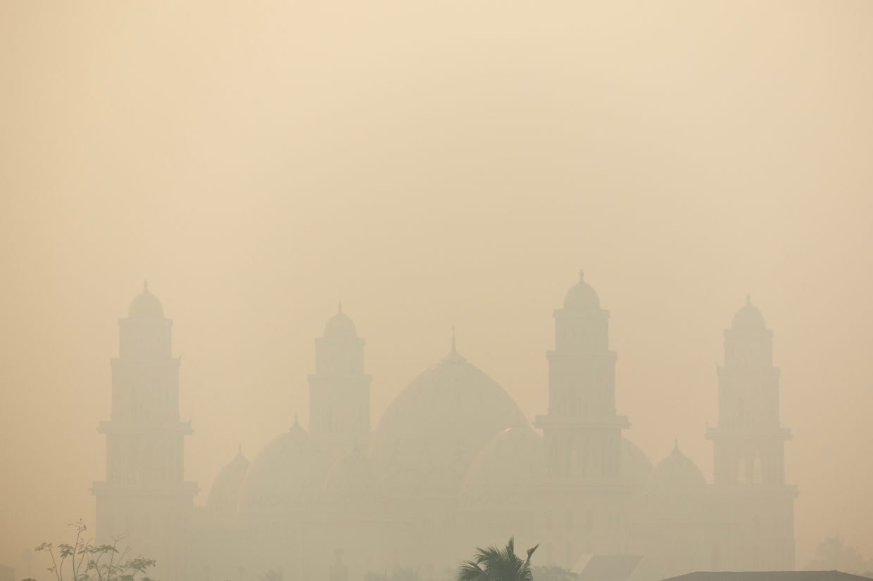
Al Ikhlas Grand Mosque is shrouded in haze from wildfires that cover the area in Ketapang, West Kalimantan province, Indonesia, August 29, 2026. Dense smoke haze has been seen over southern and central Sumatra and various parts of Kalimantan on most days since Aug 21. - Reuters
SINGAPORE: Since August, countries in South-East Asia, including Indonesia and Malaysia, have been choking in a blanket of persistent haze caused by raging fires in Indonesia.
Dense smoke haze has been seen over southern and central Sumatra and various parts of Kalimantan on most days since Aug 21.
Forest fires in Indonesia are more easily sparked during the ongoing dry season, which usually stretches from June to October. In 2026, the fire season is further worsened by a “Godzilla” El Nino phenomenon, which makes the weather hotter and drier.
The confluence of these events has conjured flashbacks of the region’s worst air pollution incident in 2015. That year was also an El Nino year, and the fires caused the Pollutant Standards Index (PSI) – a measure of air quality in Singapore – to soar above 300 in September, reaching hazardous levels and forcing schools to shut for a day. Half a million cases of respiratory infection were recorded in Indonesia then.
But weather experts said a repeat of such a disaster in 2026 seems unlikely, mainly because the onset of El Nino happened around June, later than the April onset in 2015. This means that the effects of 2026’s El Nino will have a shorter overlap with the traditional dry season.
However, the severity of haze pollution experienced here can also be affected by other factors.
What leads to haze over Singapore?
The severity of haze and when it occurs depend on the duration of dry weather, wind conditions and direction relative to the location of fires, the extent of burning, as well as measures taken on the ground to suppress fires, said the National Environment Agency (NEA).
During the current dry south-west monsoon season, winds are expected to blow from the south. Smoke plumes from southern Sumatra and the southern parts of Kalimantan could be transported towards Singapore if the fires intensify, said NEA.
Other weather events, such as typhoons near Singapore, could also contribute to the appearance of haze over the Republic, said Wang Jingyu, a weather expert and assistant professor at the National Institute of Education.
For instance, two typhoons brewing near the northern part of South-East Asia on Aug 24, when the PSI in central Singapore neared the unhealthy range of 101 and above, could have contributed to the hazy conditions over Singapore that day, said Wang.
He explained: “The two typhoons, Narra and Saudel, developed over the north-east of South-East Asia. These systems concentrated moisture around themselves, making South-East Asia even drier on top of the existing dry conditions already worsened by El Nino.”
The typhoons also strengthened winds from the south and promoted the movement of transboundary haze towards Singapore, he added.
The PSI in the central region inched up to 99 before dropping.
Since then, the PSI has dropped to the moderate range.
How does 2026’s El Nino affect haze forecasts?
While both 2015 and 2026 are super El Nino years, the NEA and weather experts do not think that the 2026 forest fires will match the extent of those in 2015.
This is because the current El Nino started later than the 2015 cycle. The El Nino in 2015 had an onset in April, and a long impact on the dry season, said NEA.
“Extensive fires and dense haze were observed across the region, resulting in prolonged periods of air quality registering ‘Unhealthy’ or worse over Singapore,” said a spokesperson.
In comparison, the 2026 El Nino started later around June, and the number of hot spots over Sumatra and Kalimantan so far is lower than in 2015.
NEA noted that there could still be periods of haze, especially during prolonged dry spells.
“The severity and duration of haze episodes will depend on how the ground situation subsequently develops and the extent of fires,” said the agency.
According to the Indonesian government’s forest fire monitoring system, more than 202,000ha of forest and land had been burned by the end of July 2026.
In comparison, the 2015 inferno charred about 2.6 million ha of land during the fire season.
Koh Tieh Yong, adjunct associate professor in meteorology and climate science at NUS, stressed that transboundary haze is at its core a man-made disaster sparked by using fire to clear land for agriculture.
If hot-spot detection, fire-fighting efforts and enforcement achieve their objectives, “we may still avert the worst impacts this year compared to 2015”, he said.
What is causing the widespread fires in Indonesia?
Fire is widely used as a cheaper option for agricultural land clearing by both smallholders and plantation companies, as burning costs far less than machines, said Dede Sulaeman, research lead for peatland monitoring at the World Resources Institute (WRI) Indonesia.
Many of the hot spots are seen on plantation land, called concessions, he added. “Concessions represent land with full control by companies, which should play a significant role in preventing fires and achieving a zero-fire target,” said Dede.
His colleague Muslih Biladi, a land use and supply chain analyst, added: “Many companies still struggle to keep fires from breaking out, and even large firms continue to see hot spots turn up in their subsidiaries’ concessions or in supplier areas near their production sites.”
Agricultural land in Sumatra and Kalimantan has been a tinderbox for decades since waterlogged peatlands were drained for plantations, making the land dry and flammable.
El Nino just amplifies the human-caused burning. “The risk is therefore highest when human activities occur in already degraded or drained landscapes and coincide with prolonged drought,” Dede said.
Wahyu Perdana, advocacy, campaign and communication manager of non-governmental organisation Pantau Gambut, noted that since 2015, the government has made important improvements in early warning, firefighting capacity and fire-prevention efforts.
“However, the persistent challenge is that responses remain too often reactive, sporadic and incident-based, whereas peatland fire management requires structural and preventive intervention,” he added.
In end-August, the Indonesian authorities arrested 89 people suspected of starting forest and peatland fires.
Dede added: “Although law enforcement efforts have been strengthened, challenges remain in establishing the causes and chain of responsibility for forest and land fires.”
The budget allocated to firefighting has also shrunk in 2026. While the Indonesian government has set aside five trillion rupiah (US$282 million) in reserve funds for disaster response, firefighting will need to contend with competing needs, including the recent major earthquake in East Nusa Tenggara, he noted.
What affects the strength of an El Nino?
An El Nino is declared when the temperatures of the sea surface in the central and eastern Pacific Ocean – roughly between Australia and South America – warms by at least 0.5 deg C above the norm.
A strong El Nino happens when the warming is at least 1.5 deg C. A super, or “Godzilla”, El Nino happens when the sea surface warms 2 deg C and above.
According to the Australian meteorology bureau, the sea surface temperature in this El Nino monitoring region has risen by 2.45 deg C. It added that the current warming of the central equatorial Pacific is forecast to reach levels above the warmest seen since proper records began in 1950.
Koh said El Nino develops because of an instability in the interaction between the tropical Pacific Ocean and the atmosphere. How strong these unstable disturbances grow is random.
“But the stronger they are, the more rarely they occur. We have had very strong El Ninos once every 10 to 20 years since instrumental records began. The current occurrence seems to follow this pattern,” he added.
A new study tracing El Ninos of the past 900 years – published in scientific journal Science in August – has shown that the phenomenon has been exacerbated by climate change. - The Straits Times/ANN
Thank you for your report!
Singapore's 2026 economic growth forecast raised to 5% - MAS survey
Singapore sends team to Nepal to support disaster relief efforts
Singapore-based TikToker Lev Panfilov cleared of raping woman due to inconsistencies in her testimony
2026年8月29日,印度尼西亚西加里曼丹省吉打邦县的阿尔伊赫拉斯大清真寺笼罩在野火产生的烟雾之中。自8月21日以来,苏门答腊南部和中部以及加里曼丹岛多个地区几乎每天都被浓烟笼罩。——路透社
新加坡:自 8 月以来,包括印度尼西亚和马来西亚在内的东南亚国家一直笼罩在由印度尼西亚肆虐的火灾造成的持续烟雾之中。
自 8 月 21 日以来,苏门答腊南部和中部以及加里曼丹岛部分地区几乎每天都出现浓烟。
印尼的森林火灾在持续的旱季期间更容易发生,旱季通常从6月持续到10月。2026年,厄尔尼诺现象(一种类似哥斯拉的极端气候)将使火灾季节更加严峻,因为该现象会导致天气更加炎热干燥。
这些事件的交织让人回想起该地区2015年最严重的空气污染事件。那一年也是厄尔尼诺年,火灾导致新加坡空气质量指标——污染物标准指数(PSI)在9月份飙升至300以上,达到危险水平,迫使学校停课一天。当时印尼记录了50万例呼吸道感染病例。
但气象专家表示,2026年再次发生此类灾难的可能性似乎不大,主要原因是厄尔尼诺现象的发生时间大约在6月,比2015年的4月晚。这意味着2026年厄尔尼诺现象的影响与传统旱季的重叠时间会更短。
然而,这里雾霾污染的严重程度也可能受到其他因素的影响。
新加坡上空出现雾霾的原因是什么?
国家环境局(NEA)表示,雾霾的严重程度和发生时间取决于干燥天气的持续时间、风况和风向相对于火灾地点、燃烧范围以及地面上采取的灭火措施。
新加坡国家环境局表示,目前正值西南季风干燥季节,预计风向将来自南方。如果火势加剧,来自苏门答腊南部和加里曼丹南部的烟雾可能会被吹向新加坡。
新加坡国立教育学院气象专家、助理教授王景宇表示,其他天气事件,例如新加坡附近的台风,也可能导致新加坡出现雾霾。
王先生表示,例如,8月24日,东南亚北部附近有两个台风正在酝酿,当时新加坡中部地区的空气污染指数接近101以上,处于不健康范围,这可能是造成新加坡当天出现雾霾天气的原因之一。
他解释说:“台风纳拉和沙德尔在东南亚东北部形成。这些系统将水汽聚集在周围,使得东南亚在厄尔尼诺现象加剧的干旱基础上更加干燥。”
他还补充说,台风也加强了来自南方的风力,并促进了跨境烟霾向新加坡移动。
中心区域的PSI值小幅上升至99,然后回落。
此后,PSI值已降至中等水平。
2026年的厄尔尼诺现象将如何影响雾霾预测?
虽然 2015 年和 2026 年都是超级厄尔尼诺年,但国家环境局和气象专家认为 2026 年的森林火灾规模不会与 2015 年的森林火灾规模相当。
这是因为当前的厄尔尼诺现象开始得比2015年的周期要晚。国家环境局表示,2015年的厄尔尼诺现象始于4月,并对旱季产生了长期影响。
一位发言人表示:“该地区出现大范围火灾和浓烟,导致新加坡空气质量长时间处于‘不健康’或更差水平。”
相比之下,2026 年厄尔尼诺现象开始得较晚,大约在 6 月份,而且到目前为止,苏门答腊岛和加里曼丹岛上空的热点数量也低于 2015 年。
国家环境局指出,仍可能出现雾霾天气,尤其是在持续干旱期间。
该机构表示:“雾霾的严重程度和持续时间将取决于地面情况的后续发展和火灾的范围。”
根据印尼政府的森林火灾监测系统,截至2026年7月底,已有超过202000公顷的森林和土地被烧毁。
相比之下,2015 年的大火在火灾季节烧毁了约 260 万公顷的土地。
新加坡国立大学气象与气候科学系兼职副教授许铁勇强调,跨境雾霾本质上是一场人为灾害,是由用火清理土地用于农业而引发的。
他说,如果热点检测、消防工作和执法能够达到预期目标,“与 2015 年相比,我们今年或许还能避免最严重的后果”。
印尼各地发生大范围火灾的原因是什么?
世界资源研究所(WRI)印度尼西亚泥炭地监测研究负责人德德·苏莱曼表示,火烧是一种更便宜的农田清理方式,小农户和种植园公司都广泛使用这种方式,因为燃烧的成本远低于使用机器。
他补充说,许多火灾热点都出现在被称为特许经营地的种植园土地上。“特许经营地是指公司完全控制的土地,这些公司应该在预防火灾和实现零火灾目标方面发挥重要作用,”德德说。
他的同事,土地利用和供应链分析师穆斯利赫·比拉迪补充道:“许多公司仍在努力防止火灾发生,即使是大型公司也继续在其子公司的特许经营地或生产基地附近的供应商区域看到热点出现。”
几十年来,苏门答腊和加里曼丹的农业用地一直像个火药桶,因为人们排干了原本水涝的泥炭地用于种植园,导致土地干燥易燃。
厄尔尼诺现象只会加剧人为造成的焚烧。“因此,当人类活动发生在已经退化或排水的土地上,并且恰逢长期干旱时,风险最高,”德德说。
非政府组织 Pantau Gambut 的倡导、宣传和传播经理 Wahyu Perdana 指出,自 2015 年以来,政府在预警、消防能力和防火工作方面取得了重要进展。
“然而,持续存在的挑战是,应对措施往往过于被动、零星和以事件为基础,而泥炭地火灾管理需要结构性和预防性干预,”他补充道。
8月底,印尼当局逮捕了89名涉嫌纵火焚烧森林和泥炭地的人员。
德德补充道:“尽管执法力度有所加强,但在确定森林和土地火灾的原因和责任链方面仍然存在挑战。”
2026年,分配给消防的预算也有所缩减。他指出,虽然印尼政府已拨出5万亿印尼盾(2.82亿美元)的储备金用于灾害应对,但消防仍需应对其他方面的竞争需求,包括最近东努沙登加拉发生的大地震。
哪些因素会影响厄尔尼诺现象的强度?
当太平洋中部和东部海域(大致位于澳大利亚和南美洲之间)的海面温度比正常温度高出至少 0.5 摄氏度时,就会宣布发生厄尔尼诺现象。
当气温升高至少 1.5 摄氏度时,就会发生强厄尔尼诺现象。当海面温度升高 2 摄氏度及以上时,就会发生超级厄尔尼诺现象,或者说是“哥斯拉”厄尔尼诺现象。
据澳大利亚气象局称,该厄尔尼诺监测区域的海面温度已上升2.45摄氏度。气象局还表示,目前中赤道太平洋的变暖预计将达到自1950年有正式记录以来的最高水平。
科赫表示,厄尔尼诺现象的形成是由于热带太平洋与大气层之间的相互作用不稳定造成的。这些不稳定扰动的强度发展是随机的。
“但厄尔尼诺现象越强,发生的频率就越低。自仪器记录开始以来,我们大约每10到20年就会经历一次非常强烈的厄尔尼诺现象。目前的厄尔尼诺现象似乎也符合这一规律,”他补充道。
一项追踪过去900年厄尔尼诺现象的新研究——发表于8月的科学期刊《科学》——表明,气候变化加剧了这一现象。——《海峡时报》/亚洲新闻网
感谢您的报告!
新加坡金融管理局调查显示,新加坡2026年经济增长预期上调至5%。
新加坡派出团队前往尼泊尔支援救灾工作
新加坡TikTok网红列夫·潘菲洛夫因受害女性证词前后矛盾而被判无罪。