I Almost Died Flying Into A Mountain Near Kobe’s Crash: Veteran Navy Pilot Explains The Risks我差点在科比坠机地点附近撞山丧命:资深海军飞行员讲述风险
The truth is that accidentally flying into clouds happens more than anyone wants to admit. I break down the Kobe crash and my own brush with death.
新闻视频
Updated Feb 20, 2020 2:39 PM EST
One of the most disorienting and dangerous things that can happen to a pilot during flight is inadvertently entering Instrument Meteorological Conditions (IMC). While this is a known hazard and can be easily avoided by thorough preflight preparation and in-flight weather observation, it still occurs fairly regularly. Three weeks ago, it likely happened to the helicopter carrying retired NBA star Kobe Bryant and eight other people. That flight ended in tragedy with the death of all aboard. Twenty years ago, the same thing almost happened to me in the same area.
My crew and I escaped that near catastrophe with our lives by the narrowest of margins. The reality is that it can happen to anyone, from the private pilot on a weekend recreational flight to the passenger-carrying helicopter pilot on a routine hop with a beloved sports star and his friends and family onboard to the most capable and well-trained military pilot. Here’s what we know about the Kobe flight and why it reminded me of my own brush with death.
There is a tremendous amount of confusing and even misleading information in the public domain about this tragedy and how helicopters are operated, in general. So, before I get to my own story of experiencing a very similar situation while flying HH-60H Seahawk helicopters in the Navy, let’s break it all down in order to provide a comprehensive picture of the circumstances surrounding the incident.
What started out as a routine helicopter flight two weeks ago from John Wayne Airport in Orange County, California, to Camarillo Airport in Camarillo, California, ended in tragedy when the Sikorsky S-76 helicopter crashed into a hillside in Calabasas, California. Bryant, his 13-year-old daughter Gianna, and seven other people died in the crash.
While the final report from the National Transportation Safety Board (NTSB) will not be completed for some time, there is enough evidence in the public domain and within the NTSB Aircraft Accident Investigative Update released on February 7th to make some informed observations about the incident.
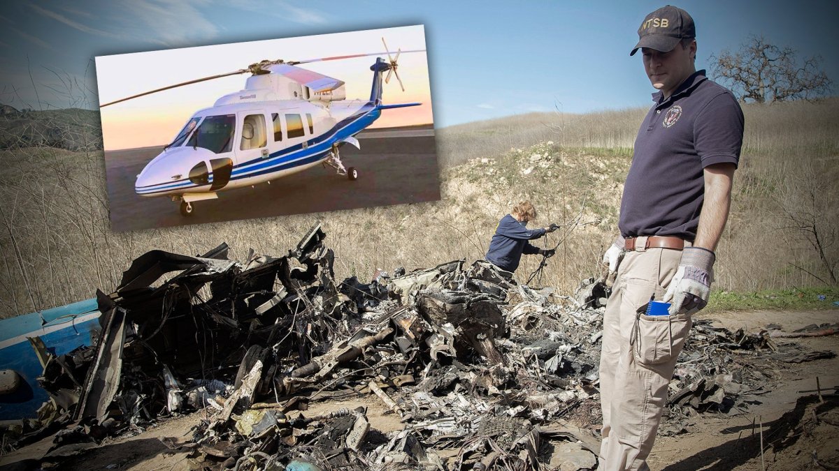
The helicopter involved in the crash. , NTSB
In this case, the helicopter was single piloted on a Visual Flight Rules (VFR) flight plan. During the flight, the pilot observed weather conditions degrading and asked for and received permission to continue the flight under Special Visual Flight Rules (SVFR), which we will discuss in detail in a moment.
While the helicopter type, the Sikorsky S-76, is certified for flight in Instrument Meteorological Conditions, the operator of this specific airframe, Island Express Helicopters, had an operating certificate from the Federal Aviation Administration (FAA) that limited its operations to Visual Meteorological Conditions (VMC) only.
In other words, while this individual S-76 helicopter may or may not have been capable of IMC flight, it was not authorized for it. Shortly before crashing, the helicopter appears to have inadvertently entered IMC and began maneuvering aggressively, possibly in an attempt to escape those conditions.
Meteorological Conditions, Pilot Ratings, Aircraft Certifications, And Flight Plans
In order to understand the sequence of events that led to the tragic death of nine people, we need to understand some basic terminology and regulations that describe meteorological conditions, pilot ratings, aircraft certifications, and flight plans.
In terms of weather, there are two basic classifications of meteorological conditions that apply to flight operations. These are Visual Meteorological Conditions (VMC) and Instrument Meteorological Conditions (IMC). The parameters that determine these classifications are set by the FAA with respect to visibility, cloud ceiling, and separation from clouds, both vertically and horizontally, during flight.
These VMC minimums vary according to the type of airspace that is being flown in. VMC and IMC are mutually exclusive conditions. At any given time, every major airport in the United States with a control tower operates under either VMC or IMC conditions based on actual local weather observations.
In terms of operating aircraft, pilots are licensed, certified, and rated by the FAA in a number of different categories, like a private or commercial pilot or certified flight instructor. All pilots qualify under VFR conditions and may obtain an advanced instrument rating that authorizes them to fly in IMC.
With respect to what type of weather that specific aircraft can fly in, each individual aircraft operating in the United States must obtain an airworthiness certificate before operating. Every aircraft, at a minimum, is authorized to fly in VFR conditions. In order to legally operate under IMC conditions, aircraft must have additional equipment, including heading indicator, attitude indicator, altimeter adjustable for barometric pressure, two-way radio, transponder, and specific navigation equipment. In general, the required navigation equipment varies based on the date of manufacture of the airframe.
In terms of flight plans, any flight that goes into the FAA’s airway system must file an Instrument Flight Rules (IFR) flight plan prior to takeoff, regardless of the weather conditions. Flights that do not use the FAA airway system should file a VFR flight plan. Special Visual Flight Rules (SVFR) is a unique category of flight clearance . It is used when an aircraft operating under VFR rules encounters weather that meets the criteria for IMC conditions, but where continued safe operation is possible under VFR rules.
With the basic definitions and terminology of weather, pilot ratings, aircraft certifications, and flight plans in place, let’s consider what happened in this specific instance.
Sequence Of Events Leading To The Crash
We have a pretty good amount of detail on the sequence of events leading to the crash, especially with the help of the FAA’s preliminary report on the incident.
Regarding the helicopter and pilot, we know that the mishap helicopter was single piloted and on a VFR flight plan. Ara Zobayan, the pilot of the helicopter, had commercial pilot, rotorcraft (helicopter), and instrument helicopter ratings . This means he was qualified to fly a commercial helicopter, with paying passengers, under IMC conditions on an IFR flight plan, as long as that individual helicopter and operator company was certified for flight in IMC. In this case, even though he personally was qualified to file and fly IFR flight plans, the company he worked for, Island Express Helicopters, was only authorized to file and fly VFR flight plans.
This is not unusual. It is very common for helicopters to only operate in VMC conditions, on a VFR flight plan. A VFR flight plan simply requires that the aircraft remain clear of controlled airspace, unless in two-way radio communication with air traffic control (ATC) for a temporary transit through controlled airspace, and to remain clear of fog, clouds, rain, or any other weather condition that would obscure visual reference to navigational checkpoints on the ground. The vast majority of helicopter flights in the United States take place under VMC conditions, under VFR rules.
The most direct route of flight from John Wayne Airport to Camarillo Airport is to head northwest over Los Angeles, then continue over the Santa Monica Mountains. This course would take the aircraft directly through Los Angeles International Airport’s (LAX) Class B airspace. Accordingly, the flight path would have to deviate to the east around that Class B airspace or follow an established VFR transition route through that airspace. This route of flight going near LAX and then over the Santa Monica Mountains to Camarillo had been used by Island Express Helicopters on a number of previous flights and the pilot Ara Zobayan had flown this VFR route the previous day.
Regarding the weather at the time of launch, both fog and a low cloud layer were present which precluded the direct route of flight over the Santa Monica Mountains. The Los Angeles Police Department grounded its helicopter flight operations that morning due to fog and low clouds.
One of the consistent local weather phenomena in Southern California is the presence of a marine layer of fog that can develop over the ocean and quickly moves inland. With poor weather reported and observed near the coast, the pilot reasonably decided to divert his route further inland, to the east. Rather than flying northwest over Los Angeles into fog and clouds, he flew to the east of downtown Los Angeles towards Glendale.
After flying east of downtown Los Angeles, according to data posted on Flightradar24, the helicopter completed six holding turns over Glendale. Holding turns are used when a flight needs to delay its progress before continuing on course, and may vary in duration, altitude, and geometry depending on the location and reason for holding. The most common cause of holding turns is in response to direction from air traffic control to facilitate proper spacing and sequencing of flights.
In addition to responding to direction from air traffic control to enter holding, aircraft may also initiate a request to enter holding. One of the most common causes of holding requests from aircraft to air traffic control is to avoid dangerous weather conditions.
Based on transcripts posted on LiveATC.net and the NTSB update, the helicopter entered holding over Glendale in response to direction from air traffic control to facilitate traffic flow into and out of Hollywood Burbank Airport, located just northwest of Glendale. There is no indication in these transcripts that the weather had anything to do with the initial direction from air traffic control to hold and no indication that the pilot requested to hold.
The final flight path of the helicopter including the holding turns over Glendale. , Flightradar24.com
After completing holding turns in order to facilitate traffic flow, the pilot then requested permission from air traffic control to proceed through Burbank Airport airspace under the aforementioned SVFR rules. Because Burbank Airport is designated as Class C airspace, the weather minimums to operate under normal VFR flight rules are three statute miles visibility with aircraft operating at least 500 feet below, 1,000 feet above, and with 2,000 feet of horizontal separation from clouds.
Based on air traffic control communication and the pilot’s request to fly through Burbank airspace under SVFR rules, we can conclude that the weather was below VFR minimums at that point. There is nothing inherently unsafe about flying in SVFR conditions, as long as the pilot is trained to fly in such conditions. Of course, flying in SVFR conditions does present a greater risk than flying in VFR conditions, which is why FAA regulations prohibit air traffic control from suggesting this option to pilots. If a pilot wants to fly in marginal weather below VFR, the pilot must initiate the request to air traffic control to fly in special VFR conditions.
According to an audio clip of the radio communications between Zobayan and air traffic control posted online and from the NTSB’s recent update, as the pilot transited through Burbank Airport airspace he relayed his route of flight intentions to air traffic control. Based on that conversation, his intended route of flight was to follow Interstate 5 to the northwest of Burbank Airport, then California State Route 118 to the west, closer to his intended destination at Camarillo Airport. This route of flight allowed for an expeditious transit through Burbank Airport airspace and also kept the helicopter clear of Van Nuys Airport, which is located just west of Burbank Airport. Following major freeways and roads is a very common navigation technique used by helicopter pilots operating under VFR flight plans.
After following Interstate 5 and State Route 118 around Burbank and Van Nuys airspace, the flight continued in a westerly direction towards Thousand Oaks. At that point, it was positioned for a relatively direct path further to the west to Camarillo. Unfortunately, that path had rising terrain both to the north and south and was experiencing degraded weather conditions.
Shortly after that final radio communication, the helicopter turned sharply left, heading south, and then entered a steep rate of descent as it continued the left turn to nearly due east, and crashed into a hillside. At the time of impact, Automatic Dependent Surveillance-Broadcast (ADS-B) transponder and radar data referenced by the NTSB update showed that the helicopter was in a left turn, descending at over 4,000 feet per minute and 161 knots immediately before impact.
Regarding the weather at the time of the crash, the Weather Channel reported that clouds and fog were present. Shortly after the crash, the Los Angeles County Sheriff’s Department posted a picture showing a layer of fog or low clouds directly above the crash site. One eyewitness reported hearing the helicopter shortly before the crash, but could not see it due to the low cloud layer. Another eyewitness was hiking near the scene of the crash and reported seeing the helicopter emerge from the clouds in a descending and turning flight path immediately before crashing.
Analyzing The Data For Causation
In the early history of aviation, the vast majority of mishaps were caused by a mechanical malfunction. As aircraft design, manufacturing, and maintenance processes have improved in modern times, mechanical malfunctions have decreased as a causal factor for mishaps. According to the FAA, the vast majority of modern air mishaps are caused by human error . While we cannot conclusively state at this point that this crash was caused exclusively by pilot error, it is very plausible, if not probable, based on the information we have, that the pilot made a mistake by inadvertently flying into IMC conditions.
Regarding the data showing the helicopter moving at 161 knots and descending at over 4,000 feet per minute at the moment of impact, these are well outside the normal operating parameters of the S-76 helicopter. There is simply no reason for a helicopter in IMC conditions, with passengers on board, to intentionally enter a rate of descent over 4,000 feet per minute and exceed the maximum cruising speed of the aircraft (155kts), especially when operating at low altitudes.
As a comparison, the H-60 Seahawk helicopter, a high-performance military helicopter that I piloted for 20 years in the Navy, had a normal descent rate of about 500 feet per minute while on instrument approaches. In some circumstances, depending on airspeed, terrain, and other traffic in the area, the helicopter might have a decent rate of up to 1,000 feet per minute during certain maneuvers. Anything above that is outside the normal operating envelope, even if the aircraft is mechanically capable of higher rates of descent.
The only time I experienced a 4,000 foot per minute rate of descent was during fully developed, power off autorotations or maximum performance powered descents, which only happen under very specific conditions requiring both high speed and high rate of descent.
While it is extremely unlikely that this helicopter encountered a mechanical malfunction that required a fully developed, power off autorotation or a maximum performance powered descent, there are some technically plausible scenarios that could have caused this.
The NTSB has ruled out catastrophic engine failure as a causal factor. In this context, this means NTSB has concluded the engines did not disintegrate in flight. With that said, it is possible that the helicopter suffered a dual engine failure without it being a catastrophic failure.
Such scenarios are extremely uncommon, but they do happen. U.S. Airways Flight 1549, a fixed-wing Airbus A320 airliner, experienced a bird strike in flight which caused both engines to shut off, resulting in a forced landing into the water in 2009. You can see the NTSB animation and air traffic control recordings related to that mishap here .
If this S-76 helicopter encountered a dual bird strike into the engine intakes, it is possible it suffered a dual engine flameout, the only response to which would be an autorotation. Such an engine failure would not necessarily result in immediately identifiable damage.
Another possibility is contaminated fuel leading to a dual engine flameout, necessitating a fully developed autorotation. As far as powered maximum rate of descent goes, if a fire occurred in the cockpit or cabin, that would necessitate an immediate powered maximum rate of descent to find the first survivable landing zone. Because the post-crash fire consumed much of the helicopter wreckage, and because the helicopter was not equipped with a Cockpit Voice Recorder (CVR) or Flight Data Recorder (FDR) “black boxes,” which might have contained evidence of an onboard fire, it will be more challenging for the NTSB to conclusively rule this possibility out.
An onboard fire was the exact scenario that led to Swissair Flight 111, a fixed-wing McDonnell Douglas MD-11 airliner, crashing just off the coast of Nova Scotia, killing all 229 passengers and crew on board, in 1998. You can read the Transportation Safety Board of Canada report on that accident here .
Flying in IMC presents no mechanical challenge to the helicopter. It doesn’t matter to the aircraft if it is flying in clear air or clouds. It is simply an issue of whether or not the aircraft is equipped with the proper instruments for flight in IMC conditions and whether or not the pilot is capable of flying on instruments with no external visual reference. Currency in training for these conditions is a factor as well.
As far as loss of control of the aircraft by the pilot, that is a plausible causal factor. Operating in poor weather at relatively low altitude and with rising terrain on either side of the aircraft, it simply isn’t reasonable that the pilot intentionally entered an extremely high rate of descent at high speed during a course reversal (a rapid about-face in direction of flight).
Based on all of these data points and my extensive experience flying helicopters in marginal weather conditions, all factors seem to indicate the pilot inadvertently entered IMC, then executed a sharp turn in an attempt to return to VMC conditions, shortly before crashing. This is not to say conclusively that the flight crashed because of the pilot error of inadvertently entering IMC. It is possible that the pilot entered inadvertent IMC, then suffered a mechanical malfunction that caused the crash. We won’t know the full cause of the crash until the NTSB finishes its final report, which may take up to 18 months.
Accident Investigation And National Transportation Safety Board (NTSB)
Shortly after the crash, the NTSB activated its “Go Team” and sent 18 accident investigators to the crash site. According to the NTSB , the purpose of the Go Team is to respond to the site of a major accident as quickly as possible. This team, working in coordination with local law enforcement, secures the crash site and starts the laborious process of collecting all the physical evidence at the scene. This is especially important if a mechanical malfunction was the cause of the crash.
Modern investigative techniques and technologies are able to determine with a high degree of accuracy whether or not the main components of the airframe were functioning correctly at the time of the crash, but only if the crash site is secured from contamination and disruption. Following the recovery of the components, typically the airframe is rebuilt in a hangar so investigators can see the entire structure, or at least what is left of it.
Without any help from the cockpit voice recorder or flight data recorder (FDR) “black boxes,” the NTSB investigation will have to rely on data collected external to the aircraft, including air traffic control voice and radar recordings. While the crash occurred on an uninhabited hillside, numerous eyewitnesses observed the helicopter immediately prior to it entering IMC conditions, or heard it while it was in IMC conditions, and their statements will also be part of the investigation.
Flight Data Recorders and Cockpit Voice Recorders that are hardened to survive crashes have become increasingly miniaturized and tailored to the airframes that host them. New models combine both functions in one box., YSSYguy/wikicommons
Even without the black boxes, the wreckage of the helicopter may confirm or rule out the rather remote possibility of the aircraft suffering a mechanical failure prior to the crash.
One issue that becomes readily apparent in the aftermath of this crash is the tension between the NTSB and the FAA. The former agency investigates and makes recommendations; the latter is responsible for actually implementing regulations.
Based on earlier crashes involving S-76s, the NTSB had made several recommendations to enhance safety of flight, as well as assist in data collection as part of mishap investigations.
Specifically, in an Aircraft Accident Report (AAR) resulting from an S-76 crash in 2004, the NTSB previously recommended that the FAA mandate installation of the Terrain Awareness and Warning System (TAWS) on all “existing and new U.S.-registered turbine-powered rotorcraft certificated for six or more passenger seats.”
The FAA did not concur with this recommendation and it was never implemented. Additionally, the NTSB recommended as part of that same report that the FAA “require all rotorcraft operating under 14 Code of Federal Regulations Parts 91 and 135 with a transport-category certification to be equipped with a cockpit voice recorder (CVR) and a flight data recorder (FDR).” As with the recommendation for TAWS, the FAA did not concur with the recommendation to mandate installation of CVR or FDR.
The S-76 that crashed with Kobe Bryant and other passengers on board was not equipped with TAWS, CVR, or FDR. Had the S-76 been equipped with TAWS, it may have helped the pilot maintain situational awareness with respect to the rising terrain on both sides of his aircraft. Had the S-76 been equipped with a CVR and FDR, the NTSB investigation would certainly be informed with more accurate data to determine the exact cause of this crash.
An example of a TAWS system for helicopters:
While the external data collected from air traffic control radar and radio logs helps, it does not record the multiple, minute details only available from data collection internal to the aircraft, such as pitch and roll attitude, power setting, control inputs, and much more. A CVR would add another layer of critical and far more nuanced evidence. All this would be accessible very quickly if the recorders were successfully retrieved from the wreck.
While I take no position on whether the NTSB or FAA is correct on the issue of mandatory installation of TAWS, CVR, and FDR, I am confident that this high profile fatal accident will reignite the debate on what equipment should be mandatory onboard helicopters carrying paying passengers.
NTSB works to examine and remove wreckage from the Santa Monica Mountains. , Photo by David McNew/Getty Images
For now, we will just have to wait for the official NTSB report to find out exactly what caused the crash. Suffice to say it seems very likely that NTSB will apportion some fault to the pilot for entering IMC conditions. While that is a grievous error that likely played some role in the crash, it is also an error that many other experienced pilots have made.
I know I did and it almost killed me, my copilot, and my two aircrewmen.
Going Inadvertent IMC Is Easier Than You Think
During a 20 year career as a Naval Aviator, I accumulated over 3,000 hours in H-60 Seahawk helicopters. On more occasions than I would like to remember, I inadvertently flew into IMC conditions. It happens more often than you might think, particularly in the Navy.
For a variety of cultural reasons, Naval Aviators adhere to the motto of “if it is not expressly prohibited, it is allowed.” This can be a great standard for achieving operational excellence and mission accomplishment, but it is an inherently risky approach to flight planning and execution.
In any case, the closest I came to crashing was due to inadvertent IMC, and oddly enough, it happened about 20 miles west of where Kobe Bryant’s helicopter crash occurred.
It Was A Routine Flight To Practice Instrument Approaches
While stationed at Naval Air Station North Island (NASNI) in San Diego as an Instructor Pilot (IP), I would occasionally fly students up the coast to Naval Air Station Point Mugu, which is right on the coast and about five miles due south of Camarillo Airport. The vast majority of our instructional flights took place between NASNI and Naval Outlying Field Imperial Beach, about 10 miles to the south, but for some syllabus flights, we would get the students out of the local area.
On this particular flight, we were going to practice multiple precision and non-precision instrument approaches, so I decided to go up the coast to Point Mugu, which is far less congested airspace than San Diego. By definition, in order to fly instrument approaches, you have to be on an IFR flight plan, so we filed the flight plan, took off, and headed up to Point Mugu.
Because airspace in Southern California is so congested, and because helicopters fly much slower than the fixed-wing commercial traffic that dominates the air traffic controllers’ workload, we typically would either request or accept non-standard flight routing to make it easier on air traffic control and ourselves. Our maximum speed in the helicopter was close to the minimum speed for most commercial airframes, so to avoid conflict with that traffic, we would occasionally file and fly point to point routing that was not part of the standard airway system.
In this case, we filed to fly direct from NASNI to Naval Auxiliary Landing Field on San Clemente Island, direct from there to Naval Outlying Field San Nicolas Island and from there to Naval Air Station Point Mugu. It was a legal IFR flight plan, all over water with no conflicting traffic. Southern California air traffic control was happy to give us offshore routing to keep out of that beehive airspace.
A Seahawk off Naval Air Station North Island in San Diego. , USN
We flew up to Point Mugu and I planned on staying there for about an hour, doing about five precision and five non-precision instrument approaches. I figured with the good weather we could request short legs on our instrument traffic pattern. For the first seven or eight approaches, everything went like clockwork. It was a late Friday afternoon, there was no airborne traffic at Point Mugu, we were the only aircraft in the pattern, so we were getting short leg approaches and easy passes.
When Complacency Sets In, Danger Is Close Behind
I thought we were in for a quick wrap up to the flight, an easy transit back down the coast to San Diego, and a fun start to the weekend. As my thoughts wandered, I failed to notice that the marine layer of fog was building up from underneath the helicopter at the same time a cloud layer was descending from above. Point Mugu tower and approach control should have told us that the weather was degrading, but it’s possible they were not paying attention. We sure weren’t.
There were no other aircraft in the pattern and our outbound legs were heading at 210 degrees, which took us almost directly into the setting sun before turning back on final to take the approach to runway 030. On our last approach, as we were flying the downwind leg directly into the sun, we couldn’t see squat. I assumed, incorrectly, that it was just the haze of flying into the sunset. In fact, we were entering IMC conditions and were completely unprepared for it. As we turned towards the final heading, now flying away from the sun and into darkness, I started to pick up that conditions were changing rapidly.
NAS Point Mugu facing south with the nearby Santa Monica mountains clearly visible. , Google Earth
For all the previous approaches, we could see the runway through the entirety of the approach. This time, we couldn’t see anything except the fog beneath us. In the five minutes since our last approach, fog had completely obscured our sightline to the airfield. At the same time, I saw a solid wall of clouds ahead of us.
Since we were on an instrument approach and on an IFR flight plan, there was no problem flying into the cloud, but I had not done the IMC checklist. We had flown up to Point Mugu on an IFR flight plan, but since the weather was so clear, we had not actually configured the aircraft for flight in IMC conditions.
From Unaware Of IMC To Unprepared For IMC
When transiting from VMC to IMC conditions, there are a number of aircraft settings that need to be reconfigured.
For example, the anti-collision lights need to be off. Having anti-collision lights illuminating inside a cloud and reflecting back into the cockpit can be disorienting and even vertigo-inducing. The pitot heat should be on anytime the aircraft is flying through visible moisture, whether rain, clouds, or fog. The pitot-static system provides inputs for many of the instruments required to fly safely in IMC conditions and if it accumulates water, it can malfunction. It seems like a small thing, but ice crystals in the pitot tubes leading to inaccurate airspeed indications was one of the causal factors of the Air France Flight 447 mishap, which involved a fixed-wing Airbus A330 airliner, in 2009.
Seahawk cockpit and crew. , USN
Once I saw we were about to go IMC, I took the controls from my student and directed him to configure the cockpit for IMC operations. As we entered the cloud, I realized our instrument panel lights were completely off. This is normal during daytime VFR conditions. You don’t need your instruments backlit if you can see them with ambient light, but given that I had just flown into a cloud, I needed my instrument backlighting turned on as soon as possible. My student copilot fumbled in the dark, couldn’t quite find the correct switch and instead inexplicably turned on his flashlight and shined it in my face, temporarily blinding me. I resisted the urge to beat him senseless and continued to fly the aircraft.
That was the point where I first realized we were in serious trouble, flying in total IMC, with no instrument panel lights on, and this regrettable, avoidable, and potentially fatal situation was entirely my fault.
Fortunately, we got the instrument panel lights on and equipment correctly configured and at that point I called air traffic control to cancel the approach and get vectors to establish back on my IFR flight plan to return to San Diego. I figured we could do our last required instrument approach or two back at NASNI.
Controllers Are Human And Make Mistakes Too
We canceled the approach and air traffic control acknowledged, but like us, the controller had not been paying attention and was unprepared to give us vectors to get out of the approach pattern and back onto our IFR flight plan. The controller instructed us to maintain runway heading and 500 feet altitude while he coordinated our return to San Diego.
A word about altitude management: air traffic control clearances are always given in altitude with reference to Mean Sea Level (MSL). 500 feet MSL does not necessarily mean 500 feet Above Ground Level (AGL). I knew this, but was about to get a very rude reminder of it.
Another note about air traffic control. It was obvious with us being the only aircraft in the pattern on a lazy Friday evening that the controllers simply were not paying attention to us until the point where we canceled the approach and requested vectors offshore to get back on our flight to San Diego.
At this point, we had flown several miles past the runway threshold, but we were still holding at 500 feet MSL, our last assigned altitude. I called air traffic control and asked for the status of our request for vectors back to San Diego. The controller told me to turn right to 180 degrees on the compass, otherwise known as south.
All our previous turns for the practice approaches had been to the left, away from the Santa Monica Mountains, to a downwind heading of 210 degrees, exactly opposite of our final approach course of 030 degrees to runway 030. For some reason, this controller at this point lost situational awareness and turned us toward the mountains, which I could not see, because we were completely in the clouds. I knew the mountains were there, but, and there is no way to say this without sounding like an idiot, in the transition from VMC to IMC I simply forgot about them.
As I rolled out heading 180 degrees I reacquired situational awareness of the existence of the mountains, but did not know where they were relative to my aircraft and thought we must be clear of them, because there is no way air traffic control would give me vectors at low altitude into rising terrain.
The Grim Reaper Enters The Equation
At this point, I knew something was wrong, but wanted to figure out what it was before I called air traffic control. As that thought went through my head, I saw my radar altimeter rapidly spinning down. Overwater, the radar altimeter and barometric altimeter should read more or less the same. In this case, my barometric altimeter showed stable at 500 feet MSL, but because I was flying into rising terrain, my radar altimeter showed a constantly decreasing altitude above ground level.
In an instant, I realized what had happened. I knew I was flying straight towards a mountain and my radar altimeter was displaying the constantly decreasing separation between me and the rising terrain I was flying over. We were within five seconds at most of crashing, probably closer to three seconds, and the overwhelming emotion I experienced was not fear, but rage.
How could I have been so stupid?
Two options flashed through my mind. I could maintain heading and simply apply maximum power and try to execute a low speed, maximum performance climb to get over the mountains. This would have been the easiest option in terms of control inputs and aerodynamics. It would only have required a slight nose back adjustment to trade forward airspeed for vertical altitude, and application of maximum power. The other option was to roll into a maximum angle of bank turn, also at maximum power to turn away from the rising terrain.
I took the turn option and rolled into a 45-degree angle of bank turn to the right, and applied maximum power. Rather than use the extra power to try to climb, I thought I had a better chance of avoiding the crash if I used the power to increase my rate of turn and tighten my radius of turn.
As I did this, I heard a different controller from air traffic control radio me in a panicked voice to turn right immediately to avoid rising terrain. I did not acknowledge the transmission as I was already executing the turn and wanted my total concentration on completing a high angle of bank turn at maximum power in total IMC conditions. That’s a situation tailor-made to depart controlled flight and I knew my priorities were to aviate, navigate, then communicate. So I simply didn’t respond to air traffic control.
Example of an air traffic control tower at a Naval Air Station, in this case, NAS North Island. , USN
At the same time, as I rolled into the turn, I watched the radar altimeter continue to wind down and started its aural warning beep as we got within 100 feet of the ground beneath us. WIth 99 percent power set at a 45-degree angle of bank, the aircraft was at or near its maximum turn rate, but still, the radar altimeter continued to display the decreasing distance between the aircraft and the ground.
It didn’t last more than three or four seconds, but it felt like forever as I saw the readout go from 100 feet above ground level to 80 feet and then 60 feet before showing a rapid increase in altitude, indicating we were now flying away from the rising terrain. I continued the turn past 270 degrees to 360 degrees for just a little extra peace of mind. I cross-checked my magnetic and electronic compasses to make sure I really was heading directly away from the mountains. They matched, and I breathed a sigh of relief.
Alive And Headed Home
Of course, I had traded one problem for another. Air traffic control had given me bad vectors, I initially accepted them, then of my own accord changed my route of flight to avoid the mountains. Now I was flying on a path directly between NAS Point Mugu and Camarillo Airport without vectors or altitude direction from air traffic control all while in total IMC.
I keyed my microphone to call in just as yet another air traffic control chimed in and asked “Where are you going? What is your request?” I replied in a voice shaking with post adrenaline dump nervousness, “I just need vectors offshore to pick up my IFR flight plan back to San Diego.”
Two minutes later we were overwater, heading directly for San Nicolas Island, then San Clemente Island, then San Diego. Enroute, I debriefed the crew on what had happened. I don’t think any of them realized how close we had come to crashing. I told them air traffic control had given us bad vectors and that I accepted those vectors because I had lost situational awareness of where the mountains were.
The fog manifests seemingly out of nowhere and suddenly around the Santa Monica Mountains and especially near NAS Point Mugu., Ted Eckmann/UCSB.edu
By the book, I should have filled out a safety report when I got back to San Diego. While I blamed myself, air traffic control also made some mistakes and I should have documented both sides of the problem. I didn’t make a conscious decision to not submit a safety report, I just didn’t do it. I think I was so stunned by the whole episode. By the time we got back to San Diego, to a nearly deserted hangar on a Friday night of a three day weekend, it just didn’t occur to me to do the right thing and document it.
I was just happy to be alive.
IMC May Be Unavoidable, But Should Never Be Inadvertent
There is rarely an excuse for experiencing inadvertent IMC. Flying into IMC conditions may be unavoidable, but it should never be inadvertent.
With that said, almost every pilot I know has made this same mistake at one time or another. I can’t say conclusively that the crash that killed Kobe Bryant, his daughter, and their friends was because the pilot, Ara Zobayan, inadvertently entered IMC conditions. I can say that when I did something similar, I had a vastly better set of circumstances to rescue me from the consequences of my poor decisions than he did.
I had an overpowered and lightly loaded military aircraft that was equipped and certified to fly under complete IMC conditions. I trained regularly to fly in complete IMC conditions. I had a competent copilot to configure the cockpit instruments and give me verbal backup on my instrument scan, and I was under constant (if temporarily incorrect) air traffic control guidance to vector me to safety. Even with all those advantages, I came within a second or two of crashing into the side of a mountain not far from where Kobe’s S-76 did the same.
While it may sound crazy to the average person that any licensed professional pilot could fly directly into conditions that they were not prepared for, the cold hard truth is that it is not uncommon. Every helicopter pilot who has flown long enough has experienced a similar situation or some other avoidable brush with death. It is the unadvertised nature of the job.
Editor’s Note: We reached out to Island Express Helicopters for comment and they declined to comment at this time.
Chris Harmer is a retired Naval Aviator. He flew SH-60F and HH-60H helicopters, accumulating approximately 3,500 total flight hours. During his career, he was designated as both an Instructor Pilot and a Seahawk Weapons Instructor Pilot, and is a graduate of the Navy’s Mountain Flying School. He has flown training and operational missions in the airspace of over 50 different countries. He is a regularly scheduled military and national security analyst on multiple cable television networks including Fox, CNN, MSNBC, and BBC.
Contact the editor: Tyler@thedrive.com
Comments couldn’t be loaded. Please refresh the page.
更新于美国东部时间2020年2月20日下午2:39。
飞行过程中,飞行员最容易遇到的危险之一就是误入仪表气象条件(IMC)。虽然这是众所周知的危险,可以通过充分的飞行前准备和飞行中气象观测轻松避免,但它仍然经常发生。三周前,载有退役NBA球星科比·布莱恩特和其他八人的直升机很可能就遭遇了这种情况。那次飞行以悲剧告终,机上人员全部遇难。二十年前,我在同一地区也差点遇到同样的情况。
我和我的机组人员侥幸从那场几乎致命的灾难中死里逃生。事实上,这种情况可能发生在任何人身上,从周末休闲飞行的私人飞行员,到载着深受爱戴的体育明星及其亲友执行例行飞行任务的载客直升机飞行员,再到经验最丰富、训练有素的军方飞行员。以下是我们对科比航班事件的了解,以及它为何让我想起了自己与死神擦肩而过的经历。
关于这场悲剧以及直升机的一般操作方式,公开信息中充斥着大量令人困惑甚至误导的内容。因此,在我讲述自己驾驶海军HH-60H海鹰直升机时遇到的类似情况之前,让我们先来梳理一下事件的来龙去脉,以便全面了解事件的来龙去脉。
两周前,一架西科斯基S-76直升机从加利福尼亚州奥兰治县的约翰·韦恩机场飞往加利福尼亚州卡马里奥的卡马里奥机场,原本是一次例行飞行,却以悲剧告终。直升机在加利福尼亚州卡拉巴萨斯撞山坠毁。科比·布莱恩特、他13岁的女儿吉安娜以及其他七人在事故中丧生。
虽然美国国家运输安全委员会 (NTSB) 的最终报告还需要一段时间才能完成,但公开领域和 2 月 7 日发布的 NTSB 飞机事故调查更新中已有足够的证据,可以对该事件做出一些有根据的观察。
涉事直升机。,美国国家运输安全委员会
在这种情况下,直升机由一名飞行员驾驶,按照目视飞行规则(VFR)飞行。飞行过程中,飞行员发现天气状况恶化,于是申请并获准按照特殊目视飞行规则(SVFR)继续飞行,我们稍后将详细讨论SVFR。
虽然西科斯基 S-76 型直升机已获得在仪表气象条件下飞行的认证,但该特定机型的运营商 Island Express Helicopters 获得的联邦航空管理局 (FAA) 运营证书却将其运营限制在目视气象条件 (VMC) 内。
换句话说,虽然这架S-76直升机可能具备也可能不具备仪表气象条件(IMC)飞行能力,但它并未获得相关授权。坠毁前不久,这架直升机似乎无意中进入了仪表气象条件,并开始进行剧烈机动,可能是为了摆脱这种状况。
气象条件、飞行员等级、飞机认证和飞行计划
为了了解导致九人不幸丧生的事件经过,我们需要了解一些描述气象条件、飞行员等级、飞机认证和飞行计划的基本术语和规定。
就天气而言,适用于飞行作业的气象条件主要分为两大类:目视气象条件 (VMC) 和仪表气象条件 (IMC)。美国联邦航空管理局 (FAA) 根据飞行期间的能见度、云底高度以及与云的垂直和水平间隔等参数来设定这些分类。
这些目视气象条件(VMC)的最低标准会根据飞行空域的类型而有所不同。VMC 和仪表气象条件(IMC)是互斥的。在美国,所有设有塔台的主要机场在任何特定时间都会根据实际的当地气象观测结果,在 VMC 或 IMC 条件下运行。
在飞机操作方面,飞行员需获得美国联邦航空管理局 (FAA) 颁发的执照、认证和等级,分为多种类别,例如私人飞行员、商业飞行员或认证飞行教员。所有飞行员都必须在目视飞行规则 (VFR) 条件下取得资格,并可获得高级仪表等级,从而获准在仪表气象条件 (IMC) 下飞行。
关于特定飞机可在何种天气条件下飞行,在美国运营的每架飞机都必须在运营前获得适航证。每架飞机至少都获准在目视飞行规则 (VFR) 条件下飞行。为了在仪表气象条件 (IMC) 下合法运营,飞机必须配备额外的设备,包括航向指示器、姿态指示器、气压可调高度表、双向无线电、应答器和特定的导航设备。一般来说,所需的导航设备会根据飞机的生产日期而有所不同。
就飞行计划而言,任何进入美国联邦航空管理局(FAA)航路系统的航班,无论天气状况如何,都必须在起飞前提交仪表飞行规则(IFR)飞行计划。不使用FAA航路系统的航班则应提交目视飞行规则(VFR)飞行计划。特殊目视飞行规则(SVFR)是一种特殊的飞行许可类别。当按照VFR规则运行的飞机遇到符合仪表气象条件(IMC)的天气状况,但仍能在VFR规则下继续安全飞行时,可以使用SVFR。
在掌握了天气、飞行员等级、飞机认证和飞行计划的基本定义和术语之后,让我们来考虑一下在这个具体案例中发生了什么。
导致车祸的一系列事件
我们已经掌握了导致坠机事件发生的一系列相当详细的信息,尤其是在美国联邦航空管理局关于该事件的初步报告的帮助下。
关于直升机和飞行员,我们已知事故直升机为单人驾驶,并按照目视飞行规则(VFR)飞行。飞行员阿拉·佐巴扬(Ara Zobayan)持有商用飞行员执照、旋翼机(直升机)执照和仪表飞行等级。这意味着,只要直升机和运营公司拥有在仪表气象条件下飞行的资质,他就有资格在仪表气象条件下,按照仪表飞行规则(IFR)飞行计划驾驶载有付费乘客的商用直升机。在本案中,尽管他个人有资格提交和执行仪表飞行规则(IFR)飞行计划,但他所在的公司——岛屿快运直升机公司(Island Express Helicopters)——仅被授权提交和执行目视飞行规则(VFR)飞行计划。
这并不罕见。直升机通常只在目视气象条件下(VMC)按照目视飞行规则(VFR)飞行。VFR飞行计划仅要求飞机避开管制空域,除非与空中交通管制(ATC)进行双向无线电通信,以便临时穿越管制空域;并且飞机必须避开雾、云、雨或任何其他可能妨碍目视识别地面导航检查点的天气状况。在美国,绝大多数直升机飞行都是在VMC条件下按照VFR规则进行的。
从约翰·韦恩机场到卡马里奥机场的最直接航线是先向西北方向飞越洛杉矶,然后继续飞越圣莫尼卡山脉。这条航线会将飞机直接带入洛杉矶国际机场(LAX)的B级空域。因此,飞行路线必须绕行B级空域向东偏转,或者遵循既定的目视飞行规则(VFR)过渡航线穿过该空域。岛屿快线直升机公司(Island Express Helicopters)之前曾多次使用这条靠近洛杉矶国际机场,然后飞越圣莫尼卡山脉到达卡马里奥的航线,飞行员阿拉·佐巴扬(Ara Zobayan)前一天也曾飞行过这条VFR航线。
起飞时的天气状况是,当时有雾和低云,导致无法直接飞越圣莫尼卡山脉。洛杉矶警察局当天上午也因雾和低云而暂停了所有直升机飞行作业。
南加州常见的局部天气现象之一是海洋上空形成的一层雾,这种雾气会迅速向内陆移动。由于沿海地区天气恶劣,飞行员决定将航线转向内陆,向东飞行。他没有选择向西北方向飞越洛杉矶,进入雾气和云层,而是从洛杉矶市中心向东飞往格伦代尔。
根据Flightradar24网站发布的数据,这架直升机在飞越洛杉矶市中心以东后,在格伦代尔上空完成了六次盘旋等待。盘旋等待是指飞机在继续航线前需要暂时中断飞行,其持续时间、高度和飞行轨迹会根据盘旋等待的地点和原因而有所不同。盘旋等待最常见的原因是响应空中交通管制部门的指令,以确保航班之间保持适当的间距和顺序。
除了响应空中交通管制的进入等待航线指令外,飞机也可以主动请求进入等待航线。飞机向空中交通管制提出等待航线请求的最常见原因之一是为了避开危险的天气状况。
根据LiveATC.net网站发布的通话记录和美国国家运输安全委员会(NTSB)的最新报告,这架直升机在格伦代尔上空盘旋等待,是响应空中交通管制部门的指令,以便疏导进出格伦代尔西北部的好莱坞伯班克机场的交通。这些通话记录中没有任何迹象表明天气与空中交通管制部门最初的盘旋指令有关,也没有任何迹象表明飞行员曾要求盘旋等待。
直升机的最终飞行路线,包括在格伦代尔上空盘旋的路线。(Flightradar24.com)
完成等待转弯以疏导交通后,飞行员向空中交通管制部门请求允许其按照上述目视飞行规则(SVFR)飞越伯班克机场空域。由于伯班克机场被划为C类空域,因此按照正常目视飞行规则(VFR)运行的最低气象条件为:能见度至少为3英里,飞机飞行高度至少低于云层500英尺,高于云层1000英尺,并与云层保持2000英尺的水平间隔。
根据空中交通管制通信以及飞行员请求按照特殊目视飞行规则(SVFR)飞越伯班克空域,我们可以断定当时的天气状况低于目视飞行规则(VFR)的最低标准。只要飞行员接受过在特殊目视飞行规则(SVFR)条件下飞行的训练,飞行本身并无不妥之处。当然,在特殊目视飞行规则(SVFR)条件下飞行确实比在目视飞行规则(VFR)条件下飞行风险更大,这也是美国联邦航空管理局(FAA)规定禁止空中交通管制向飞行员建议选择SVFR的原因。如果飞行员希望在低于目视飞行规则(VFR)的临界天气条件下飞行,则必须主动向空中交通管制提出特殊目视飞行规则(SVFR)飞行的请求。
根据网上发布的佐巴扬与空中交通管制员之间的无线电通讯录音以及美国国家运输安全委员会(NTSB)的最新报告,当飞行员飞越伯班克机场空域时,他向空中交通管制员通报了他的飞行计划。根据这次通话,他计划的飞行路线是沿5号州际公路向西北方向飞行,然后沿加州118号公路向西飞行,更接近他的目的地卡马里奥机场。这条飞行路线既能让他快速飞越伯班克机场空域,又能避开位于伯班克机场西侧的范奈斯机场。沿着主要高速公路和公路飞行是目视飞行规则(VFR)下直升机飞行员常用的导航技巧。
飞机沿着5号州际公路和118号州道绕过伯班克和范奈斯空域后,继续向西飞往千橡市。此时,飞机已做好向西飞往卡马里奥的相对直接的飞行准备。不幸的是,这条航线南北两侧地势较高,且天气状况恶劣。
在最后一次无线电通讯后不久,直升机急转弯向左,朝南飞行,随后在继续左转的过程中急剧下降,最终几乎向正东方向坠毁在山坡上。根据美国国家运输安全委员会(NTSB)更新报告中引用的自动相关监视广播(ADS-B)应答器和雷达数据,撞击发生时,直升机正处于左转弯状态,在撞击前以每分钟超过4000英尺(约1200米)的下降速度和161节(约250公里/小时)的速度下降。
关于坠机时的天气情况,天气频道报道称当时有云有雾。坠机后不久,洛杉矶县警局发布了一张照片,显示坠机地点正上方有一层雾或低云。一位目击者称,在坠机前不久听到了直升机的声音,但由于低云层遮挡,无法看到直升机。另一位目击者当时正在坠机地点附近徒步旅行,他称看到直升机从云层中出现,呈下降和转弯的飞行轨迹,随后坠毁。
分析数据以确定因果关系
在航空发展的早期,绝大多数事故都是由机械故障引起的。随着现代飞机设计、制造和维护工艺的改进,机械故障作为事故原因的比例有所下降。据美国联邦航空管理局(FAA)称,绝大多数现代航空事故是由人为失误造成的。虽然我们目前还不能断定此次坠机完全是由飞行员失误造成的,但根据我们掌握的信息,飞行员很可能(甚至极有可能)因无意中飞入仪表气象条件(IMC)而犯了错误。
数据显示,直升机在撞击瞬间以161节的速度飞行,并以超过每分钟4000英尺的速度下降,这远远超出了S-76直升机的正常运行参数。在仪表气象条件下,载有乘客的直升机没有任何理由故意以超过每分钟4000英尺的下降率飞行,并超过飞机的最大巡航速度(155节),尤其是在低空飞行时。
作为对比,我曾在海军驾驶20年的高性能军用直升机H-60“海鹰”在仪表进近时的正常下降率约为每分钟500英尺。在某些情况下,根据空速、地形和周围其他飞机的情况,该直升机在进行特定机动飞行时,下降率可能达到每分钟1000英尺。超过这个数值的下降率都超出了正常运行范围,即使飞机在机械上能够承受更高的下降率。
我唯一一次体验到每分钟 4,000 英尺的下降速度,是在完全展开的无动力自旋或最大性能动力下降过程中,而这种情况只会在非常特定的条件下发生,需要高速和高下降率。
虽然这架直升机发生机械故障,需要完全展开的无动力自旋或最大功率动力下降的可能性极小,但有一些技术上合理的场景可能会导致这种情况发生。
美国国家运输安全委员会(NTSB)已排除发动机灾难性故障是事故原因的可能性。这意味着NTSB的结论是发动机并非在飞行中解体。即便如此,直升机仍有可能遭遇双发动机故障,但并非灾难性故障。
这种情况极其罕见,但确实会发生。2009年,全美航空1549号航班,一架固定翼空客A320客机,在飞行途中遭遇鸟击,导致双引擎熄火,最终迫降在水中。您可以在这里查看美国国家运输安全委员会(NTSB)制作的与该事故相关的动画和空中交通管制录音。
如果这架S-76直升机遭遇双鸟撞击,发动机进气口可能同时被两只鸟击中,导致双发熄火,此时唯一的应对措施就是自旋着陆。这种发动机故障不一定会立即造成明显的损坏。
另一种可能性是燃油污染导致双引擎熄火,需要完全自旋。就动力最大下降率而言,如果驾驶舱或客舱内发生火灾,则必须立即以最大动力下降率寻找第一个可安全着陆区。由于坠机后的火灾吞噬了大部分直升机残骸,且该直升机未配备驾驶舱语音记录器(CVR)或飞行数据记录器(FDR)“黑匣子”(可能包含机上起火的证据),因此美国国家运输安全委员会(NTSB)要彻底排除这种可能性将更加困难。
1998年,瑞士航空111号航班(一架麦道MD-11型固定翼客机)在加拿大新斯科舍省海岸附近坠毁,机上229名乘客和机组人员全部遇难,而导致坠机的原因正是机上起火。您可以在这里阅读加拿大运输安全委员会关于该事故的报告。
在仪表气象条件下飞行对直升机本身并无机械方面的挑战。无论是在晴空还是云层中飞行,对飞机本身而言都无关紧要。关键在于飞机是否配备了适用于仪表气象条件的飞行仪表,以及飞行员是否具备在没有外部目视参考的情况下进行仪表飞行的能力。此外,飞行员是否接受过此类条件下的飞行训练也是一个重要因素。
至于飞行员失去对飞机的控制,这确实是一个合理的因果因素。在天气恶劣、飞行高度相对较低且飞机两侧地形隆起的情况下,飞行员在航向反转(快速改变飞行方向)过程中故意以极高的速度进入极高的下降率,这显然是不合理的。
根据所有这些数据点以及我在恶劣天气条件下驾驶直升机的丰富经验,所有因素似乎都表明飞行员无意中进入了仪表气象条件(IMC),然后在坠机前不久为了试图返回目视气象条件(VMC)而进行了一次急转弯。但这并不能断定坠机完全是由于飞行员无意中进入IMC造成的。飞行员有可能无意中进入了IMC,然后遭遇了导致坠机的机械故障。在国家运输安全委员会(NTSB)完成最终报告之前,我们无法得知坠机的全部原因,而最终报告的撰写可能需要长达18个月的时间。
事故调查和国家运输安全委员会(NTSB)
事故发生后不久,美国国家运输安全委员会(NTSB)立即启动了“快速反应小组”,并派遣18名事故调查员前往事故现场。据NTSB称,快速反应小组的职责是尽快赶赴重大事故现场。该小组与当地执法部门协调合作,封锁事故现场,并开始收集现场所有物证,这项工作尤为重要。如果事故是由机械故障引起的,这项工作就显得尤为重要。
现代调查技术能够高精度地确定飞机机身的主要部件在坠毁时是否正常工作,但这只有在坠机现场免受污染和干扰的情况下才能实现。部件回收后,通常会在机库内重建机身,以便调查人员能够查看整个结构,或者至少是残存的部分。
由于没有驾驶舱语音记录器或飞行数据记录器(FDR)“黑匣子”的帮助,美国国家运输安全委员会(NTSB)的调查将不得不依赖从飞机外部收集的数据,包括空中交通管制语音和雷达记录。虽然坠机地点位于无人居住的山坡上,但众多目击者在直升机进入仪表气象条件(IMC)之前曾看到过它,或在它处于IMC条件下时听到过它的声音,他们的证词也将作为调查的一部分。
为了应对坠机事故,飞行数据记录器和驾驶舱语音记录器变得越来越小型化,并针对不同的机型进行了定制。新型号甚至将这两种功能集成在一个设备中。(图片来源:YSSYguy/wikicommons)
即使没有黑匣子,直升机的残骸也可以证实或排除飞机在坠毁前发生机械故障这种可能性很小的情况。
此次事故发生后,一个显而易见的问题是国家运输安全委员会(NTSB)和联邦航空管理局(FAA)之间的紧张关系。NTSB负责调查并提出建议,而FAA则负责实际执行相关法规。
根据之前涉及 S-76 的坠机事故,美国国家运输安全委员会 (NTSB) 提出了几项建议,以提高飞行安全,并协助收集事故调查数据。
具体来说,在 2004 年 S-76 型飞机坠毁事故的飞机事故报告 (AAR) 中,美国国家运输安全委员会 (NTSB) 此前建议美国联邦航空管理局 (FAA) 强制要求所有“现有的和新的美国注册的、经认证可搭载六个或更多乘客座位的涡轮动力旋翼机”安装地形感知和警告系统 (TAWS)。
美国联邦航空管理局(FAA)不同意这项建议,该建议也从未被采纳。此外,美国国家运输安全委员会(NTSB)在同一份报告中建议FAA“要求所有根据《联邦法规》第14篇第91和135部分运营且持有运输类认证的旋翼机配备驾驶舱语音记录器(CVR)和飞行数据记录器(FDR)”。与地形感知和告警系统(TAWS)的建议一样,FAA也不同意强制安装CVR或FDR的建议。
科比·布莱恩特和其他乘客乘坐的S-76飞机坠毁时,该机并未配备地形感知与告警系统(TAWS)、驾驶舱语音记录器(CVR)或飞行数据记录器(FDR)。如果S-76配备了TAWS,或许能够帮助飞行员更好地感知飞机两侧逐渐升高的地形。如果S-76配备了CVR和FDR,美国国家运输安全委员会(NTSB)的调查无疑将获得更准确的数据,从而确定此次坠机的确切原因。
直升机地形感知与告警系统(TAWS)示例:
虽然从空中交通管制雷达和无线电日志中收集的外部数据有所帮助,但它无法记录只有通过飞机内部数据收集才能获得的诸多细微信息,例如俯仰和滚转姿态、动力设置、控制输入等等。驾驶舱语音记录器(CVR)可以提供另一层至关重要且更为细致的证据。如果能成功从飞机残骸中找到记录器,所有这些信息都将很快可供查阅。
虽然我对美国国家运输安全委员会 (NTSB) 或美国联邦航空管理局 (FAA) 在强制安装地形感知与告警系统 (TAWS)、驾驶舱语音记录器 (CVR) 和飞行数据记录器 (FDR) 的问题上的观点是否正确不持立场,但我相信,这起备受瞩目的致命事故将重新引发关于载有付费乘客的直升机应该强制安装哪些设备的辩论。
美国国家运输安全委员会(NTSB)正在对圣莫尼卡山脉的飞机残骸进行勘察和清理。(图片来源:David McNew/Getty Images)
目前,我们只能等待美国国家运输安全委员会(NTSB)的官方报告,才能确切了解事故原因。可以肯定的是,NTSB很可能会将部分责任归咎于飞行员,因为他进入了仪表气象条件(IMC)。虽然这是一个严重的错误,很可能是造成事故的原因之一,但许多其他经验丰富的飞行员也犯过类似的错误。
我知道我这么做了,差点害死了我和我的副驾驶以及我的两名机组人员。
无意中发生IMC比你想象的要容易。
在我20年的海军飞行员生涯中,我驾驶H-60海鹰直升机累计飞行超过3000小时。我曾多次无意中飞入仪表气象条件(IMC)区域,次数多到我都不愿回忆。这种情况比你想象的要常见得多,尤其是在海军。
出于各种文化原因,海军飞行员奉行“凡未明文禁止,皆可做”的准则。这或许是实现卓越作战和任务完成的重要标准,但这种飞行计划和执行方式本身就存在风险。
总之,我离坠机最近的一次是由于意外的仪表气象条件(IMC)造成的,而且奇怪的是,它发生在科比·布莱恩特直升机坠毁地点以西约 20 英里处。
这是一次例行的仪表进近练习飞行。
在圣地亚哥北岛海军航空站 (NASNI) 担任教官飞行员期间,我偶尔会驾驶飞机带学员沿海岸线飞往穆古角海军航空站。穆古角海军航空站位于海岸线上,在卡马里奥机场正南约五英里处。我们绝大多数的教学飞行都在北岛海军航空站和位于其南部约十英里的帝国海滩海军外场之间进行,但为了完成一些课程教学飞行,我们会带学员飞到当地以外的地区。
这次飞行,我们要练习多次精密和非精密仪表进近,所以我决定沿着海岸线飞往穆古角,那里的空域比圣地亚哥空域拥挤得多。根据规定,要进行仪表进近,必须提交仪表飞行规则(IFR)飞行计划,所以我们提交了飞行计划,起飞,飞往穆古角。
由于南加州空域拥挤不堪,而且直升机的飞行速度远低于占据空中交通管制员工作量的固定翼商用飞机,我们通常会申请或接受非标准飞行路线,以减轻空中交通管制和我们自身的负担。我们的直升机最高速度接近大多数商用飞机的最低速度,因此为了避免与这些飞机发生冲突,我们偶尔会申请并执行不属于标准航路系统的点对点航线。
在这种情况下,我们提交了从北爱尔兰海军航空站 (NASNI) 直飞圣克莱门特岛海军辅助着陆场,再从那里直飞圣尼古拉斯岛海军外场,最后从那里飞往穆古角海军航空站的申请。这是一份合法的仪表飞行规则 (IFR) 飞行计划,全程飞越水域,没有与其他交通冲突。南加州空中交通管制部门很乐意为我们安排近海航线,以避开那里的繁忙空域。
一架海鹰战机停在圣地亚哥北岛海军航空站附近。(美国海军)
我们飞到了穆古角,我计划在那里停留大约一个小时,进行五次精密仪表进近和五次非精密仪表进近。我想,天气这么好,我们可以申请缩短仪表飞行航线的航段。前七八次进近都非常顺利。那天是周五下午,穆古角上空没有其他飞机,航线上只有我们一架,所以我们顺利地完成了短航段进近和轻松通场。
当自满情绪滋生时,危险便近在咫尺。
我原以为这次飞行会很快结束,然后轻松地沿着海岸线返回圣地亚哥,愉快地开启周末。然而,我却心不在焉,完全没有注意到直升机下方正在积聚一层薄雾,同时上方也有一层云层正在下沉。穆古角塔台和进近管制中心本应提醒我们天气正在恶化,但他们可能并没有注意到。反正我们自己肯定没注意到。
航线上没有其他飞机,我们的出港航段航向为210度,几乎正对着落日,然后在最后进近阶段转向,准备降落030跑道。在最后一次进近时,我们顺风飞行,正对着太阳,什么也看不见。我错误地以为那只是日落时分的薄雾。事实上,我们正进入仪表气象条件(IMC),而我们对此毫无准备。当我们转向最后航向,背对太阳飞入黑暗时,我开始意识到天气状况正在迅速变化。
NAS Point Mugu 朝南拍摄,附近的圣莫尼卡山脉清晰可见。(谷歌地球)
之前几次进近,我们都能全程看到跑道。但这一次,除了脚下的浓雾,什么也看不见。自从上次进近以来,仅仅过了五分钟,浓雾就完全遮蔽了我们看向机场的视线。与此同时,我看到前方出现了一堵厚厚的云墙。
由于我们当时采用的是仪表进近,并且飞行计划也是仪表飞行规则(IFR),所以飞入云层没有问题,但我没有执行仪表气象条件(IMC)检查单。我们之前是按照IFR飞行计划飞到穆古角的,但由于天气晴朗,我们实际上并没有对飞机进行IMC条件下的飞行配置。
从对整合营销传播一无所知到对整合营销传播毫无准备
从目视气象条件过渡到仪表气象条件时,需要重新配置许多飞机设置。
例如,防撞灯必须关闭。防撞灯在云层中亮起并反射回驾驶舱会造成方向感混乱,甚至引发眩晕。飞机在可见水汽(无论是雨、云还是雾)中飞行时,皮托管加热装置必须开启。皮托管系统为许多在仪表气象条件下安全飞行所需的仪表提供输入信号,如果皮托管内积水,则可能发生故障。这看似微不足道,但皮托管内的冰晶导致空速指示不准确,却是2009年法航447航班事故(一架固定翼空客A330客机)的成因之一。
海鹰战机驾驶舱及机组人员。,美国海军
眼看就要进入仪表气象条件(IMC),我立刻从学员手中接过控制权,指示他将驾驶舱配置为IMC模式。进入云层后,我发现仪表盘的灯全灭了。这在白天目视飞行规则(VFR)条件下很正常。如果环境光足够,仪表就不需要背光,但考虑到我刚刚飞入云层,必须尽快打开仪表背光。我的学员副驾驶在黑暗中摸索,没找到正确的开关,反而莫名其妙地打开了手电筒,照在我的脸上,让我短暂失明。我强忍住想揍他一顿的冲动,继续驾驶飞机。
那时我才意识到我们遇到了大麻烦,我们在完全的仪表气象条件下飞行,仪表盘上没有任何指示灯亮起,而这种令人遗憾、本可避免且可能致命的情况完全是我的错。
幸运的是,仪表盘指示灯都亮了,设备也配置正确。这时我联系了空中交通管制,取消了进近程序,并请求引导我重新按照仪表飞行规则(IFR)飞行计划返回圣地亚哥。我想我们可以在北爱尔兰海军航空站(NASNI)完成最后几个必要的仪表进近。
控制人员也是人,也会犯错。
我们取消了进近程序,空中交通管制员也确认了,但和我们一样,管制员之前也没有注意到,也没有准备好引导我们脱离进近航线,回到仪表飞行规则(IFR)飞行计划中。管制员指示我们保持跑道航向和500英尺高度,同时协调我们返回圣地亚哥的飞行计划。
关于高度管理,需要说明一点:空中交通管制许可始终以平均海平面(MSL)为基准,并标明高度。500 英尺 MSL 并不一定意味着 500 英尺 AGL。我当然知道这一点,但即将亲身体验一番,并对此印象深刻。
关于空中交通管制还有一点要补充。在一个慵懒的周五傍晚,我们是航线上唯一的飞机,很明显,管制员根本没注意到我们,直到我们取消进近并请求引导至近海,以便重新飞往圣地亚哥。
此时,我们已经飞越跑道入口数英里,但仍保持在海拔500英尺(MSL)的高度,这是我们最后指定的飞行高度。我联系了空中交通管制,询问我们返回圣地亚哥的引导请求的状态。管制员指示我向右转至罗盘180度,也就是向南。
之前所有练习进近的转弯都是向左,远离圣莫尼卡山脉,顺风航向210度,这与我们最终进近航线030度(跑道030)正好相反。不知何故,此时管制员失去了对周围环境的感知,把我们转向了山脉,而我根本看不到山脉,因为我们完全被云层笼罩。我知道山脉就在那里,但是——这么说可能显得很愚蠢——在从目视气象条件(VMC)过渡到仪表气象条件(IMC)的过程中,我竟然把它们忘了。
当我向 180 度方向滑行时,我重新意识到了山脉的存在,但不知道它们相对于我的飞机在哪里,我认为我们必须避开它们,因为空中交通管制不可能在低空向上升起的地形发出引导。
死神登场
这时,我知道情况不对劲,但我想在联系空中交通管制之前弄清楚到底出了什么问题。就在我这么想的时候,我看到雷达高度表指针迅速下降。在水面上,雷达高度表和气压高度表的读数应该大致相同。而现在,我的气压高度表显示稳定在海平面以上500英尺,但由于我正飞向地势逐渐升高的区域,雷达高度表显示的离地高度却在不断下降。
刹那间,我意识到发生了什么。我知道自己正径直朝着一座山飞去,雷达高度表显示我与上方不断上升的地形之间的距离越来越近。我们最多只有五秒钟就要坠毁,可能不到三秒钟,而我当时最强烈的情绪不是恐惧,而是愤怒。
我怎么会这么蠢?
两种选择在我脑海中闪过。我可以保持航向,直接加大油门,尝试低速、高效率地爬升越过山脉。就操控和空气动力学而言,这无疑是最简单的选择。我只需要稍微后仰机头,用前向空速换取垂直高度,然后加大油门即可。另一种选择是,以最大坡度进行转弯,同样加大油门,避开不断上升的地形。
我选择了转弯,向右倾斜45度角转弯,并加大油门。与其用额外的动力爬升,我认为如果用动力来提高转弯速度并缩小转弯半径,更有可能避免坠机。
就在这时,我听到空中交通管制中心的另一位管制员用慌张的声音通过无线电通知我立即右转,以避开地势较高的区域。我没有回应,因为我当时已经在执行转弯操作,并且想全神贯注地在完全的仪表气象条件下以最大功率完成大角度倾斜转弯。这种情况正是离场管制飞行的理想场景,我知道我的首要任务是飞行、导航,然后才是通信。所以我干脆没有回应空中交通管制。
这是美国海军航空站(本例中为北岛海军航空站)的空中交通管制塔台示例。
与此同时,当我开始转弯时,我看到雷达高度表读数持续下降,并在距离地面不足100英尺时发出警报声。当时飞机以99%的功率和45度的倾斜角飞行,转弯速率接近或达到最大转弯率,但雷达高度表仍然显示飞机与地面之间的距离不断减小。
虽然只持续了三四秒,但感觉却像过了一个世纪那么漫长。我看到高度表从离地100英尺降到80英尺,再降到60英尺,然后高度迅速上升,表明我们正在远离那片隆起的地形。为了更加安心,我继续转弯,超过了270度,达到了360度。我仔细检查了磁罗盘和电子罗盘,确保自己确实正朝着远离山脉的方向飞行。两者读数一致,我这才松了一口气。
活着,正回家
当然,我只是从一个问题换到了另一个问题。空中交通管制给了我错误的航线引导,我一开始接受了,但后来为了避开山区,我自行更改了航线。现在,我完全处于仪表气象条件(IMC)下,在穆古角海军航空站和卡马里奥机场之间飞行,既没有空中交通管制的引导,也没有高度指示。
我按下麦克风准备通话,这时又一个空中交通管制员插话问道:“你要去哪里?有什么请求?”我回答说,声音因为肾上腺素飙升后的紧张而颤抖:“我需要一些离岸航道指引,以便执行我的仪表飞行规则(IFR)飞行计划返回圣地亚哥。”
两分钟后,我们飞越了海面,径直朝着圣尼古拉斯岛、圣克莱门特岛,最终抵达圣地亚哥。途中,我向机组人员简要介绍了刚才发生的事情。我想他们中没有人意识到我们差点坠毁。我告诉他们,空中交通管制给我们的航线指示有误,而我之所以接受这些指示,是因为我失去了对山脉位置的感知。
雾气仿佛凭空出现,突然笼罩了圣莫尼卡山脉,尤其是在穆古角海军航空站附近。(图片来源:Ted Eckmann/UCSB.edu)
按规定,我回到圣地亚哥后就应该填写安全报告。虽然我责怪自己,但空中交通管制也犯了一些错误,我应该把问题的方方面面都记录下来。我并非有意不提交安全报告,只是当时没想起来。我想我当时完全被这件事惊呆了。等我们回到圣地亚哥,在一个几乎空无一人的机库里,正值三天小长假的周五晚上,我根本没意识到应该做正确的事——把事情记录下来。
我当时只是庆幸自己还活着。
整合营销传播或许不可避免,但绝不能是无意的。
几乎没有理由意外进入仪表气象条件(IMC)。飞入IMC条件或许无法避免,但绝不应该是无意的。
话虽如此,我认识的几乎所有飞行员都曾犯过类似的错误。我无法断言科比·布莱恩特、他的女儿和朋友们遇难的那场空难一定是由于飞行员阿拉·佐巴扬无意中进入了仪表气象条件(IMC)造成的。但我可以肯定的是,当我犯下类似错误时,我的情况比他要好得多,这足以让我免于承担错误决定带来的后果。
我驾驶的是一架动力过剩、载重较轻的军用飞机,它配备了在完全仪表气象条件下飞行所需的设备和资质。我定期进行完全仪表气象条件下的飞行训练。我有一位经验丰富的副驾驶,负责配置驾驶舱仪表,并在我进行仪表扫描时提供口头指导。此外,我还始终受到空中交通管制员的引导(尽管有时会有误),以确保飞行安全。即便拥有所有这些优势,我仍然险些撞上山体,距离科比驾驶的S-76撞上山体的地方不远。
对于普通人来说,任何持有执照的专业飞行员都可能直接飞入他们毫无准备的恶劣环境中,这听起来或许匪夷所思,但残酷的现实是,这种情况并不少见。每一位飞行时间足够长的直升机飞行员都经历过类似的险境,或者其他一些本可避免的死里逃生。这就是这份工作的特殊性所在。
编者按:我们已联系 Island Express Helicopters 征求意见,但他们目前拒绝置评。
克里斯·哈默是一位退役海军飞行员。他曾驾驶SH-60F和HH-60H直升机,累计飞行时间约3500小时。在他的职业生涯中,他曾担任教官飞行员和海鹰武器教官飞行员,并毕业于海军山地飞行学校。他曾在50多个国家的空域执行过训练和作战任务。他经常受邀在包括福克斯新闻、CNN、MSNBC和BBC在内的多家有线电视网担任军事和国家安全分析员。
联系编辑:Tyler@thedrive.com
评论加载失败,请刷新页面。