Kuraman Island sand spit stretches into record books, spurring Labuan’s ecotourism appeal库拉曼岛的沙嘴绵延至创纪录的长度,极大地提升了纳闽的生态旅游吸引力。
LABUAN, Oct 12 — The natural sand spit on Kuraman Island has set two national records in the Malaysia Book of Records (MBR), with its total length measuring 808.4 metres and its...
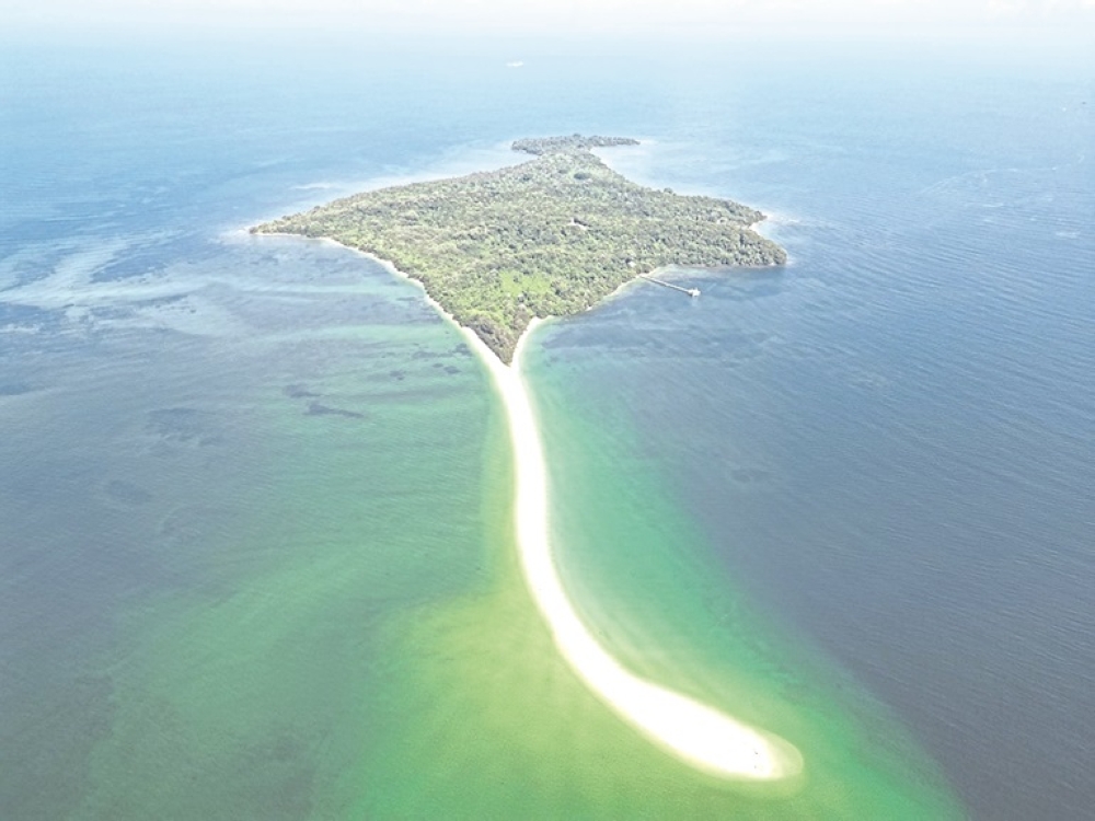
Kuraman Island's natural sand spit has set two national records in the Malaysia Book of Records for being the "Longest Natural Sand Spit in Malaysia" and the "Longest Exposed Sand Spit in Malaysia," with a total length of 808.4 metres and an exposed section of 790.4 metres.
Datuk Muhammad Azmi Mohd Zain, director-general of the Federal Territories Department, noted that this recognition highlights Labuan's geological heritage and tourism potential, aiming to boost geotourism while ensuring sustainable development.
The island is part of Labuan Geopark and features a unique geological formation estimated to be 35 million years old, contributing to its appeal as a geotourism destination.
LABUAN, Oct 12 — The natural sand spit on Kuraman Island has set two national records in the Malaysia Book of Records (MBR), with its total length measuring 808.4 metres and its exposed section measuring 790.4 metres.
The two records are ‘Longest Natural Sand Spit in Malaysia’ (Beting Pasir Semula Jadi Terpanjang di Malaysia) and ‘Longest Exposed Sand Spit in Malaysia’ (Beting Pasir Terdedah Terpanjang di Malaysia).
The certificate recognising the achievements was presented to Federal Territories Department director-general Datuk Muhammad Azmi Mohd Zain following the official declaration.
Muhammad Azmi said the recognition marked a significant milestone in efforts to promote Labuan’s geological heritage and tourism potential, while raising the profile of Kuraman Island and Labuan Geopark nationally.
Located west of Labuan near Rusukan Besar and Rusukan Kecil islands, Kuraman Island covers about 1.47 square kilometres (363 acres) and is the largest island in the Labuan Marine Park, which was gazetted in 1994.
The island’s main attraction is its natural sand spit, a distinctive geological formation extending into the sea.
Estimated to be about 35 million years old, it was formed through sediment deposition and the combined effects of longshore currents, waves and wind.
“The two MBR records were awarded based on measurements of the natural formation’s total length and exposed section. The recognition is expected to strengthen the island’s appeal as a geotourism destination, complementing its marine ecosystem, coastal scenery and distinctive geological landscape.
“It could also create opportunities for nature-based tourism and community-driven economic activities, including boat transport, recreational services, tour guiding, hospitality and small businesses,” he said to Bernama at the site today.
However, he said tourism development must be carried out responsibly to safeguard the island’s geological heritage and marine ecosystem.
“Kuraman Island is one of the key geosites under Labuan Geopark, offering visitors an opportunity to appreciate the relationship between geological history, marine biodiversity and coastal processes,” he said.
Muhammad Azmi said the recognition would support efforts to position Labuan as a tourism destination with a distinctive identity while ensuring the island’s natural heritage remains protected for future generations. — Daily Express
Fadhlina: Schools closed tomorrow in Johor, Melaka, Negeri Sembilan, Putrajaya as haze worsens
Hannah Yeoh says DBKL, police mull joint control centre for KL’s 10,000 CCTVs
Education minister: Decisions on school haze closures guided by MetMalaysia, Health Ministry and NRES
库拉曼岛的天然沙嘴在马来西亚纪录大全中创造了两项国家纪录,分别是“马来西亚最长的天然沙嘴”和“马来西亚最长的裸露沙嘴”,总长度为 808.4 米,裸露部分为 790.4 米。
联邦直辖区局总监拿督穆罕默德·阿兹米·莫哈末·扎因指出,这一认可凸显了纳闽的地质遗产和旅游潜力,旨在促进地质旅游业发展,同时确保可持续发展。
该岛是纳闽地质公园的一部分,拥有独特的地质构造,据估计已有 3500 万年的历史,使其成为地质旅游目的地的热门选择。
纳闽,10 月 12 日讯——库拉曼岛上的天然沙嘴创造了马来西亚纪录大全 (MBR) 的两项国家纪录,其总长度为 808.4 米,露出部分长度为 790.4 米。
这两项记录分别是“马来西亚最长的天然沙嘴”(Beting Pasir Semula Jadi Terpanjang di Malaysia)和“马来西亚最长的暴露沙嘴”(Beting Pasir Terdedah Terpanjang di Malaysia)。
在正式宣布之后,表彰这些成就的证书被颁发给了联邦直辖区局局长拿督穆罕默德·阿兹米·莫哈末·扎因。
穆罕默德·阿兹米表示,这一认可标志着在推广纳闽地质遗产和旅游潜力方面取得了重大进展,同时也提高了库拉曼岛和纳闽地质公园在全国的知名度。
库拉曼岛位于纳闽岛以西,靠近鲁苏坎贝萨尔岛和鲁苏坎克奇尔岛,面积约 1.47 平方公里(363 英亩),是纳闽海洋公园中最大的岛屿,该公园于 1994 年被划定。
该岛的主要景点是其天然沙嘴,这是一种独特的地质构造,延伸到海中。
据估计,它大约有 3500 万年的历史,是由沉积物堆积以及沿岸流、波浪和风的共同作用形成的。
“这两项MBR纪录是根据对自然地貌总长度和裸露部分的测量结果授予的。这一荣誉有望增强该岛作为地质旅游目的地的吸引力,使其海洋生态系统、海岸风光和独特的地质景观更加完善。”
“它还可以为自然旅游和社区驱动的经济活动创造机会,包括船只运输、休闲服务、导游、酒店服务和小企业,”他今天在现场对马新社表示。
但他表示,旅游业的发展必须以负责任的方式进行,以保护该岛的地质遗产和海洋生态系统。
“库拉曼岛是纳闽地质公园的主要地质遗址之一,为游客提供了一个了解地质历史、海洋生物多样性和海岸过程之间关系的机会,”他说。
穆罕默德·阿兹米表示,这项认可将有助于把纳闽打造成为一个具有独特个性的旅游目的地,同时确保该岛的自然遗产得到保护,造福子孙后代。——《每日快报》
Fadhlina:雾霾加剧,柔佛州、马六甲州、森美兰州和布城的学校明天停课
杨巧双表示,吉隆坡市政局和警方正在考虑设立联合控制中心,管理吉隆坡的1万个闭路电视监控摄像头。
教育部长:学校因雾霾停课的决定由马来西亚气象局、卫生部和国家应急响应系统(NRES)指导。