Malaysia’s new vehicle brings geospatial tools together for faster disaster response马来西亚的新型车辆整合了地理空间工具,以加快灾害响应速度。
KUALA LUMPUR, Oct 29 — A Defence Geospatial Information Rapid Team (DGIRT) vehicle has been introduced as a pilot project to accelerate the delivery of geospatial information in...
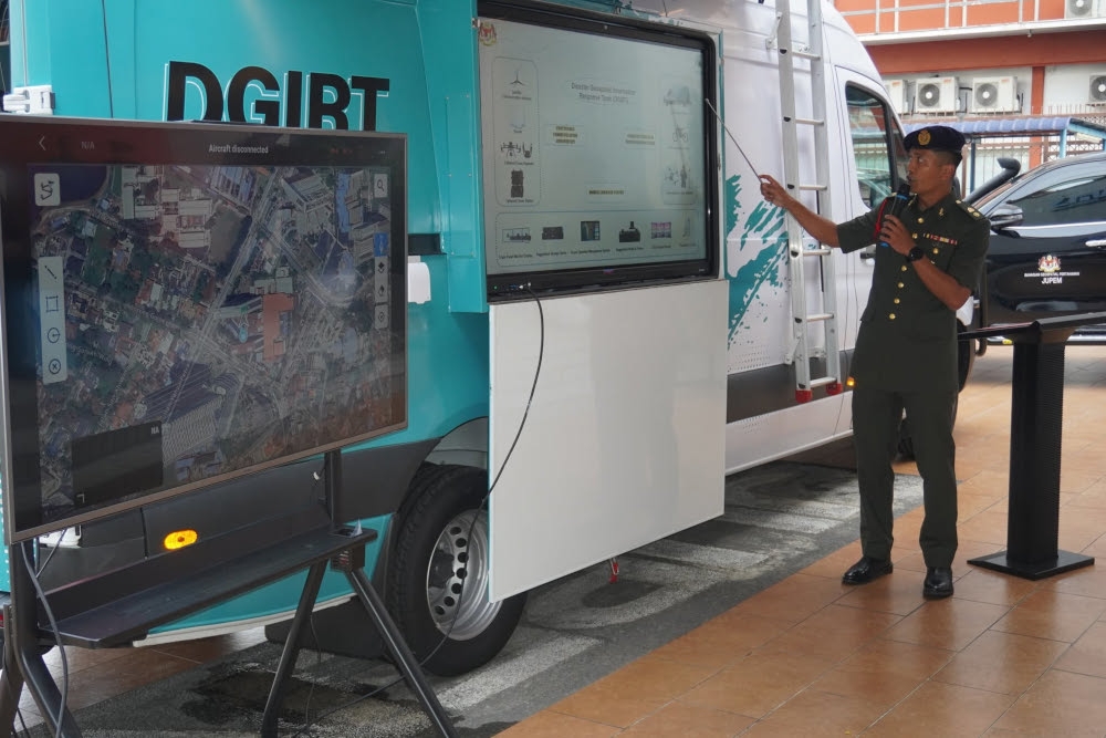
KUALA LUMPUR, Oct 29 — A Defence Geospatial Information Rapid Team (DGIRT) vehicle has been introduced as a pilot project to accelerate the delivery of geospatial information in the field, supporting defence, security and disaster management operations.
Deputy Minister of Natural Resources and Environmental Sustainability Syed Ibrahim Syed Noh said the vehicle integrates specialised geospatial equipment to enable faster and more accurate field data collection.
“The vehicle will help us obtain more precise information on the ground while expediting response efforts by enabling teams to reach disaster sites more quickly and accelerating the collection of data and information for follow-up action,” he said.
He was speaking at a press conference after launching Defence Geospatial Day 2026 (DG’26), themed “Advancing Defence and Security Through Geospatial Capabilities”, at Wisma Perwira today.
Also present were Army Chief General Tan Sri Azhan Md Othman, Defence Geospatial Division Director Brigadier General Datuk Dr Mohd Zambri Muhammad Rabab, and Deputy Director-General of Survey and Mapping Malaysia (JUPEM) 1 Ahmad Sanusi Che Cob.
Syed Ibrahim said the vehicle, developed by JUPEM in collaboration with the Malaysian Armed Forces (ATM), represented a new initiative, although the equipment and instruments it carries had been used previously, including during the landslide incident in Batang Kali, Selangor.
“The difference is that previously, we did not have a dedicated vehicle that integrated all these specific tools. Now, with this combination of equipment, including electric motorcycles and drones, assessments at disaster sites can be carried out with much greater accuracy,” he said.
He added that the initiative drew on lessons from previous disasters and took into account the operational needs of relevant agencies, including the National Disaster Management Agency (NADMA).
In his opening address, Syed Ibrahim said geospatial information went beyond mapping, describing it as a strategic national asset essential to strengthening defence preparedness, safeguarding sovereignty and improving the effectiveness of security operations.
He stressed that accurate, integrated and up-to-date information was crucial for supporting decision-making, enhancing situational awareness and ensuring the effective execution of security operations.
At the event, held for the first time in collaboration with JUPEM and ATM, Syed Ibrahim also launched the Defence Geospatial Information Management (DGIM) initiative under the 13th Malaysia Plan (RMK13).
The initiative aims to strengthen the management, integration and sharing of defence-related geospatial information.
He said the development of geospatial capabilities would also involve the use of artificial intelligence (AI) and the exploration of Environmental Intelligence (EI).
Syed Ibrahim further emphasised the importance of cooperation between civilian and military agencies in ensuring coordinated efforts to protect national security and sovereignty, including during humanitarian assistance and disaster management operations. — Bernama
Bersatu signs confidence and supply pact with Madani govt, says MPs to get same allocations as govt backbenchers
Skip toll payments and risk being tracked under new MLFF system, says works minister
Sabah targets RM100b GDP by 2030 through investment, industrial growth, says CM
吉隆坡,10 月 29 日讯——国防部地理空间信息快速小组 (DGIRT) 车辆已作为试点项目推出,旨在加快现场地理空间信息的交付,以支持国防、安全和灾害管理行动。
自然资源与环境可持续发展部副部长赛义德·易卜拉欣·赛义德·诺表示,该车辆集成了专门的地理空间设备,能够更快、更准确地收集现场数据。
他说:“这辆车将帮助我们获得更精确的地面信息,同时加快救援工作,使救援队能够更快地到达灾区,并加快收集数据和信息以采取后续行动。”
今天,他在国防大厦(Wisma Perwira)举行的2026年国防地理空间日(DG'26)启动仪式后,在新闻发布会上发表了讲话。本次DG'26的主题是“通过地理空间能力推进国防和安全”。
出席的还有陆军总司令丹斯里阿占奥斯曼、国防地理空间部门主任拿督莫哈末赞布里穆罕默德拉巴准将以及马来西亚测绘局(JUPEM)副局长艾哈迈德沙努西谢科布。
Syed Ibrahim表示,这辆由JUPEM与马来西亚武装部队(ATM)合作开发的车辆代表了一项新的举措,尽管它携带的设备和仪器以前曾被使用过,包括在雪兰莪州巴当加里发生的山体滑坡事件中。
他说:“不同之处在于,以前我们没有专门的车辆来集成所有这些特定工具。现在,有了包括电动摩托车和无人机在内的这些设备的组合,灾害现场的评估可以更加精准地进行。”
他还补充说,该倡议吸取了以往灾害的经验教训,并考虑到了相关机构(包括国家灾害管理署 (NADMA))的运作需求。
赛义德·易卜拉欣在开幕致辞中表示,地理空间信息不仅仅是地图绘制,它还是一项战略性国家资产,对于加强国防准备、维护主权和提高安全行动的有效性至关重要。
他强调,准确、综合、最新的信息对于支持决策、增强态势感知和确保安全行动的有效执行至关重要。
在本次活动中,赛义德·易卜拉欣首次与JUPEM和ATM合作举办,并启动了第十三个马来西亚计划(RMK13)下的国防地理空间信息管理(DGIM)计划。
该倡议旨在加强国防相关地理空间信息的管理、整合和共享。
他表示,地理空间能力的发展还将涉及人工智能 (AI) 的应用和环境智能 (EI) 的探索。
赛义德·易卜拉欣进一步强调了民事和军事机构之间合作的重要性,以确保协调一致地维护国家安全和主权,包括在人道主义援助和灾害管理行动中。——马新社
土著团结党与马达尼政府签署信任与供应协议,称其国会议员将获得与政府后座议员相同的拨款。
工程部长表示,逃避缴纳通行费将面临在新市政交通收费系统下被追踪的风险。
沙巴州首席部长表示,该州计划通过投资和工业发展,到2030年实现1000亿令吉的国内生产总值。