S’pore to map out marine, coastal habitats following news of western island reclamation新加坡将在西部岛屿填海造陆消息传出后,绘制海洋和沿海栖息地地图
The study will show how marine and coastal ecosystems here have changed over eight years. Read more at straitstimes.com.
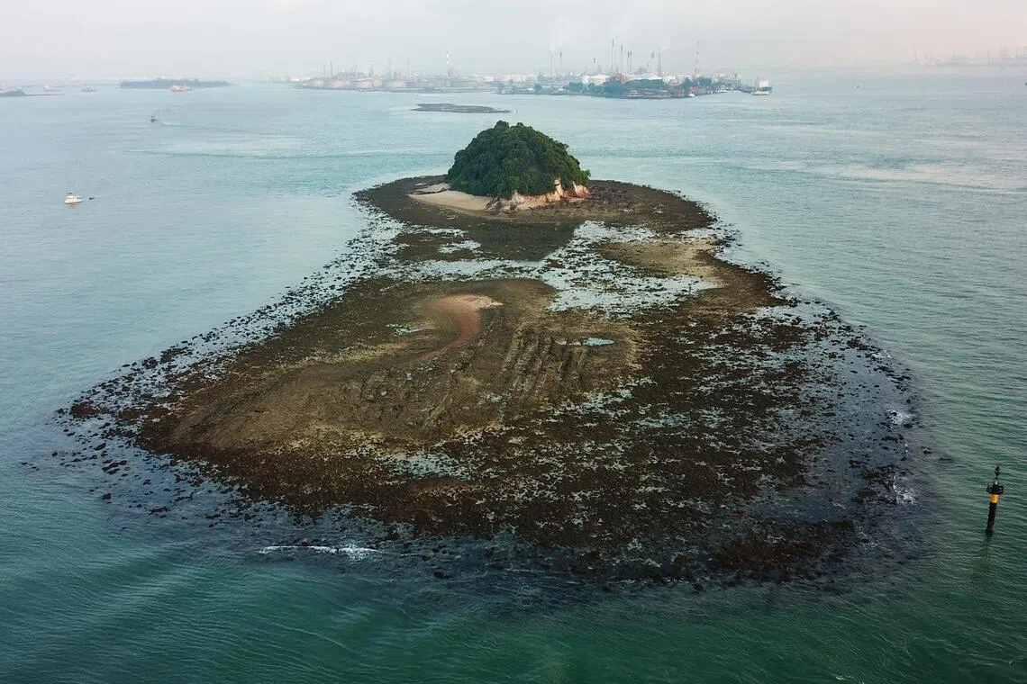
One of the islands that could be merged in the reclamation for a new western island is Pulau Jong, which is one of the last untouched islands of Singapore.
ST PHOTO: LIM YAOHUI
Published Sep 04, 2026, 04:38 PM
Updated Sep 04, 2026, 04:38 PM
NParks will conduct a new mapping study using satellite imagery to track changes in Singapore’s coastal and marine habitats since 2018, aiding conservation and development planning.
The mapping is crucial due to concerns over western island reclamation.
Stakeholders of Singapore's marine community urge consideration of recreational, social and cultural impacts,
SINGAPORE - Plans are underway to use high-resolution satellite imagery to map out how coral reefs, seagrass meadows and mangroves have changed over the years along Singapore’s coastlines.
The new images of the different types of coastal and marine habitats will update maps previously created in 2018 and 2011, according to a National Parks Board (NParks) tender seen by The Straits Times.
The tender was published on Aug 25, two days after Prime Minister Lawrence Wong announced at the National Day Rally that a new “western island” to meet industry, energy and defence needs in the coming decades would be created by merging several southern islands through reclamation. This could include Pulau Semakau, Pulau Bukom and Pulau Sudong.
NParks’ group director for the National Biodiversity Centre Karenne Tun said the map will quantify any changes to the habitats since 2018, supporting sea space and conservation planning across Singapore, while complementing research studies by various agencies.
“As with previous mapping efforts, the geospatial dataset from this study will be made publicly available,” said Tun, who noted that the exercise is part of NParks’ regular efforts to study the Republic’s coastal and marine habitats .
The mapping exercise comes amid concerns from scientists, nature groups and other members of the marine community about the reclamation plans to create a new western island.
Singapore has already lost more than two-thirds of its coral reefs and more than 45 per cent of its seagrass to land reclamation and coastal development . An estimated 85 per cent of mangroves and tidal flats have disappeared, mostly since 1953.
The NParks study is expected to take 15 months to complete, and excludes marine waters in the Pedra Branca area, according to tender documents.
Marine scientists said the mapping exercise is timely as the coastline has likely changed considerably due to events like sea-level rise, climate-driven storm surges and marine heatwaves.
Huang Danwei, deputy head of the National University of Singapore’s Lee Kong Chian Natural History Museum, said the results from the study will be critical for mitigating the impacts of ongoing coastal development projects and planning upcoming projects.
Accurate maps will provide a reference point to measure changes post-construction and help reshape reclamation profiles to avoid destroying productive coral reefs, dense seagrass beds, or mangrove forests that store significant amounts of planet-warming carbon dioxide, he noted.
Mangroves seen during an intertidal survey led by marine conservationist Ria Tan at Pulau Hantu on July 31, 2026. ST PHOTO: LIM YAOHUI
Mangroves seen during an intertidal survey led by marine conservationist Ria Tan at Pulau Hantu on July 31, 2026.
Knowing the precise boundaries and areal estimates of coastal and marine habitats are important for making predictions about biodiversity as the environment changes, he added, explaining that such knowledge can more accurately characterise and project how species that form the foundation of ecosystems will be distributed.
“Such projections are important not just for ecosystem management, but also are helpful for long-term planning of navigational routes and the sea space in general.”
Agreeing, coral scientist Sam Shu Qin, who co-chairs voluntary network Friends of Marine Park, said the mapping exercise is a step towards evidence-based identification of conservation areas or places to prioritise for intervention.
Mushroom corals seen during an intertidal survey led by marine conservationist Ria Tan at Pulau Hantu on July 31, 2026. ST PHOTO: LIM YAOHUI
Mushroom corals seen during an intertidal survey led by marine conservationist Ria Tan at Pulau Hantu on July 31, 2026.
“Researchers, educators and nature groups could use the data to support research and communicate the importance of Singapore’s remaining coastal and marine habitats and wildlife,” she added.
Marine biologist Ow Yanxiang, who co-led the city-state’s inaugural seagrass restoration project, said the data will help track cumulative changes to the coastal environment since 2018, especially since environmental impact assessments for developments in these areas are often conducted independently of one another.
The senior research fellow at the St John’s Island National Marine Laboratory said: “Our coral reefs, seagrass beds and mangroves forests have survived our nation’s many years of growth and development, so can we engineer ways to build our future with nature, instead of over it?”
A nudibranch in the waters of Pulau Hantu. PHOTO: HALIMAH RAZALI
A nudibranch in the waters of Pulau Hantu.
PHOTO: HALIMAH RAZALI
Beyond the ecological impact, dive operators, nature guides, and descendants of those who once lived in the affected islands are calling on authorities to also study the social, recreational and heritage impact of the reclamation project.
Pulau Hantu, for instance, is often regarded as the heart of Singapore’s recreational diving scene, according to Serene Pek, co-owner of Cuddlefish Divers.
Pek cited the island’s sheltered conditions, manageable depths for beginners, and rich biodiversity, including seahorses, nudibranchs, and sharks. In 2025, about 60 per cent of her company’s operations, roughly 200 trips, were conducted at Pulau Hantu.
She said: “While we understand the need for Singapore to plan for its future development, we hope that careful consideration can be given to preserving areas that support recreation, conservation, education and community activities, so that future generations can continue to enjoy and appreciate these unique marine ecosystems.”
Ng Lee Kiang, co-founder of the nature education firm Young Nautilus, is concerned that the sediment plumes from future reclamation could ripple outwards, impacting not just Pulau Hantu and Pulau Semakau, but nearby sites like Sisters’ Islands Marine Park and St John’s Island, where her company regularly runs programmes.
Leathery soft corals seen during intertidal survey led by marine conservationist Ria Tan at St John's island on Aug 14, 2026. ST PHOTO: LIM YAOHUI
Leathery soft corals seen during intertidal survey led by marine conservationist Ria Tan at St John's island on Aug 14, 2026.
She said: “As educators, our deepest hope is that generations to come will still have the chance to experience, appreciate and learn about the rich marine biodiversity we are fortunate to have today.”
Non-governmental organisation Orang Laut SG, which began as an initiative to preserve the maritime heritage of islanders living on Pulau Semakau, a subset of Singapore’s seafaring natives , has called for cultural and social impacts to be considered, as well as continued access to the surviving islands, coral reefs and coastal waters.
It said: “Environmental assessments alone cannot account for the loss of heritage, community access, livelihoods, traditional knowledge and relationships with the sea.”
Land planning/Land sales
National Parks Board
在填海造陆形成新西部岛屿的过程中,可能会合并的岛屿之一是浮罗琼岛,它是新加坡最后几个未受破坏的岛屿之一。
ST 照片:林耀辉
发布于 2026 年 9 月 4 日下午 4:38
更新于2026年9月4日下午4:38
国家公园局将利用卫星图像进行一项新的测绘研究,以追踪自 2018 年以来新加坡沿海和海洋栖息地的变化,从而帮助进行保护和发展规划。
由于人们对西部岛屿填海造地问题感到担忧,因此绘制地图至关重要。
新加坡海洋社区的利益相关者敦促考虑休闲、社会和文化影响,
新加坡——目前正在制定计划,利用高分辨率卫星图像绘制出新加坡海岸线沿线珊瑚礁、海草床和红树林多年来的变化情况。
据《海峡时报》看到的国家公园局(NParks)招标书显示,新的沿海和海洋栖息地类型图像将更新此前分别于 2018 年和 2011 年创建的地图。
该招标于8月25日发布,两天前,总理黄循财在国庆群众大会上宣布,将通过填海造陆的方式合并几个南部岛屿,打造一个新的“西部岛屿”,以满足未来几十年工业、能源和国防的需求。这些岛屿可能包括实马高岛、布科姆岛和苏东岛。
国家公园局国家生物多样性中心主任 Karenne Tun 表示,该地图将量化自 2018 年以来栖息地发生的任何变化,为新加坡的海洋空间和保护规划提供支持,同时补充各个机构的研究。
“与以往的测绘工作一样,这项研究的地理空间数据集将向公众开放,”Tun说道。他还指出,这项工作是国家公园局为研究共和国沿海和海洋栖息地而开展的常规工作的一部分。
此次测绘工作正值科学家、自然保护组织和其他海洋界人士对填海造地计划(旨在创建一个新的西部岛屿)表示担忧之际。
新加坡已有超过三分之二的珊瑚礁和超过45%的海草因填海造地和沿海开发而消失。据估计,约85%的红树林和潮滩已经消失,其中大部分是在1953年之后发生的。
根据招标文件,国家公园局的这项研究预计需要 15 个月才能完成,并且不包括白礁地区的海域。
海洋科学家表示,这项测绘工作非常及时,因为海平面上升、气候变化引发的风暴潮和海洋热浪等事件可能导致海岸线发生巨大变化。
新加坡国立大学李光前自然历史博物馆副馆长黄丹伟表示,这项研究的结果对于减轻正在进行的沿海开发项目的影响以及规划即将开展的项目至关重要。
他指出,精确的地图将为衡量施工后的变化提供参考点,并有助于重新规划填海造地路线,以避免破坏生产力高的珊瑚礁、茂密的海草床或储存大量导致全球变暖的二氧化碳的红树林。
2026年7月31日,海洋保育家Ria Tan带领团队在Pulau Hantu进行潮间带调查,期间拍摄到了红树林。(海峡时报摄影:林耀辉)
2026 年 7 月 31 日,海洋保护主义者 Ria Tan 在 Pulau Hantu 进行潮间带调查时发现了红树林。
他补充说,了解沿海和海洋栖息地的精确边界和面积估算对于预测环境变化下的生物多样性至关重要,并解释说,这种知识可以更准确地描述和预测构成生态系统基础的物种的分布情况。
“此类预测不仅对生态系统管理很重要,而且对航道和整个海域的长期规划也很有帮助。”
珊瑚科学家、海洋公园之友志愿网络联合主席秦舒珊表示赞同,她说,绘制地图是朝着基于证据确定保护区或优先干预地点迈出的一步。
2026年7月31日,海洋保育家Ria Tan带领团队在Pulau Hantu岛进行潮间带调查时,发现了蘑菇珊瑚。(海峡时报摄影:林耀辉)
2026 年 7 月 31 日,海洋保护主义者 Ria Tan 在 Pulau Hantu 进行潮间带调查时发现了蘑菇珊瑚。
她补充说:“研究人员、教育工作者和自然保护团体可以利用这些数据来支持研究,并宣传新加坡剩余的沿海和海洋栖息地及野生动物的重要性。”
海洋生物学家欧彦祥是新加坡首个海草修复项目的共同负责人,他表示,这些数据将有助于追踪自 2018 年以来沿海环境的累积变化,尤其是因为这些地区开发项目的环境影响评估通常是独立进行的。
圣约翰岛国家海洋实验室的高级研究员表示:“我们的珊瑚礁、海草床和红树林在我国多年的发展历程中幸存了下来,那么我们能否设计出与自然和谐共处、而非破坏自然的方法来建设我们的未来呢?”
汉图岛水域中的裸鳃类动物。照片:哈莉玛·拉扎利
汉图岛水域中的一只裸鳃类动物。
照片:哈利玛·拉扎利
除了生态影响之外,潜水运营商、自然向导以及曾经居住在受影响岛屿上的人们的后代也呼吁当局研究填海工程的社会、娱乐和文化遗产影响。
例如,据 Cuddlefish Divers 的共同所有人 Serene Pek 称,Pulau Hantu 通常被认为是新加坡休闲潜水的中心。
佩克指出,该岛环境隐蔽,水深适宜初学者,且生物多样性丰富,包括海马、裸鳃类动物和鲨鱼。2025年,她公司约60%的业务,也就是大约200次航行,都在汉都岛进行。
她表示:“我们理解新加坡需要规划未来的发展,但我们希望能够认真考虑保护那些支持休闲、保护、教育和社区活动的区域,以便子孙后代能够继续享受和欣赏这些独特的海洋生态系统。”
自然教育公司 Young Nautilus 的联合创始人 Ng Lee Kiang 担心,未来填海造地产生的沉积物羽流可能会向外扩散,不仅会影响 Pulau Hantu 和 Pulau Semakau,还会影响附近的 Sisters' Islands Marine Park 和 St John's Island 等地,她的公司经常在这些地方开展活动。
2026年8月14日,海洋保护主义者Ria Tan带领团队在圣约翰岛进行潮间带调查,期间发现了革质软珊瑚。(海峡时报摄影:林耀辉)
2026 年 8 月 14 日,海洋保护主义者 Ria Tan 在圣约翰岛进行潮间带调查时发现了革质软珊瑚。
她说:“作为教育工作者,我们最深切的希望是,子孙后代仍然有机会体验、欣赏和了解我们今天有幸拥有的丰富的海洋生物多样性。”
非政府组织 Orang Laut SG 最初是为了保护居住在实马高岛(Pulau Semakau)的岛民的海洋遗产而成立的,该岛民是新加坡航海原住民的一部分。该组织呼吁考虑文化和社会影响,以及继续进入现存岛屿、珊瑚礁和沿海水域的权利。
报告称:“仅凭环境评估无法解释遗产、社区通道、生计、传统知识以及与海洋关系的丧失。”
土地规划/土地出售
国家公园管理局