Drainage canal in flood-prone Bukit Timah fully upgraded after 7-year work on final stretch位于易受洪水侵袭的武吉知马的排水渠经过7年最后一段的施工,已全面升级改造完毕。
Bukit Timah canal upgrade completed, with PUB saying the enlarged drain can hold 30% more floodwater to reduce flash floods. Read more at straitstimes.com.
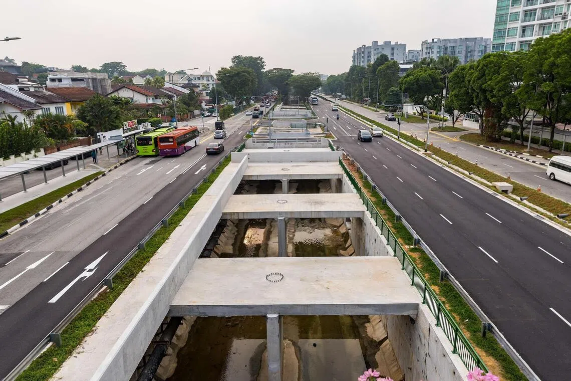
The last 900m stretch of the Upper Bukit Timah canal has been enlarged. Work to upgrade this stretch started in 2019.
Published Oct 23, 2026, 06:00 PM
Updated Oct 23, 2026, 06:00 PM
SINGAPORE - The flood-prone Bukit Timah area will likely experience some relief during the year-end rainy season, now that canal upgrading works there are completed.
National water agency PUB on Oct 23 announced that the last 900m stretch of a 2.3km canal there has been enlarged.
The upgraded canal can hold 30% more floodwater than before, which could help limit flash floods like those t hat had recurred in the area over the past 15 years.
Work to upgrade this stretch started in 2019 and was initially expected to be completed by the first quarter of 2024 . The delays were due to the Covid-19 pandemic, changes in construction schedule to minimise peak traffic congestion, among other issues.
But because of Bukit Timah’s low-lying, valley-like terrain, and due to increasingly erratic rainfall patterns caused by climate change, drainage infrastructure alone may not be able to prevent flash floods completely, PUB cautioned.
There are also limitations to installing more drains in land-scarce Singapore, the agency noted, pointing to how the whole Bukit Timah area is already served by three drainage canals spanning 10km in all.
To address this, PUB said it will at the end of 2026 call for a study to identify longer-term solutions to strengthen flood resilience across Bukit Timah.
The study will assess a range of anti-flood solutions, including underground structures to hold floodwaters. It will also explore solutions that can integrate with existing infrastructure and future developments, added PUB .
Acknowledging that the Bukit Timah area is one of Singapore’s “most challenging catchments”, PUB’s deputy chief executive of flood resilience Angela Koh said very intense storms can still overwhelm drainage infrastructure.
“We will continue to improve drainage and raise roads where feasible, while taking a holistic review of the catchment to identify more integrated solutions for the longer term,” she added.
The 2.3km Upper Bukit Timah Canal is the main anti-flood measure for a 1,000ha area. The canal runs from Beauty World to Maple Avenue.
The rainfall catchment area it supports includes homes, as well as other malls and public facilities like Beauty World Plaza, Bukit Timah Shopping Centre and Dunearn Village, as well as Beauty World and King Albert Park MRT stations.
On Oct 23, PUB announced that the final 900m stretch of the canal running from Rifle Range Road to Jalan Kampong Chantek has been widened and deepened .
Works on the final stretch, which cost about $60 million, began in October 2019. Once angular in shape, the canal has been converted into a U-shaped drain and box culvert, allowing it to convey 30% more stormwater, said PUB.
The Bukit Timah area has historically been prone to flooding because its valley-like terrain forms a basin that channels stormwater quickly into the low-lying canal. Urban development over the decades has also contributed to an increase in runoff.
The last major flooding event in the Upper Bukit Timah area was in April 20, 2025, when downpours led to flash floods in four areas including a stretch between Clementi Road and Blackmore Drive.
The flash floods subsided after about an hour, and the amount of rainfall over Singapore that evening amounted to nearly half of Singapore’s average monthly rainfall in April.
Dunearn Road near Sime Darby Centre experienced flash floods a couple of times in 2021. In August that year, a flood between Sime Darby Centre and Binjai Park affected bus operations along Dunearn Road for about an hour.
A flash flood in Dunearn Road, from Sime Darby Centre to Binjai Park, rendered the road impassable to traffic on Aug 24, 2021. PHOTO: ST READER
A flash flood in Dunearn Road, from Sime Darby Centre to Binjai Park, rendered the road impassable to traffic on Aug 24, 2021.
However, the seven - year upgrading period for the 900m stretch of the canal had also resulted in traffic congestion for commuters and residents in the area.
With several schools located in the area, traffic was also an issue for students and parents during drop-off and school dismissal times.
In 2023, Holland- Bukit Timah GRC MP Christopher de Souza had asked Parliament if the works along the 900m stretch could be expedited.
Minister for Sustainability and the Environment Grace Fu then said the works will be delayed from 2024 to 2026 to align with the development of a green corridor in the same area.
This is because the future Bukit Timah-Rochor Green Corridor will have an elevated sky park for pedestrians over the Upper Bukit Timah Canal, and PUB helped build the foundations for the sky park on top of the canal.
This elevated connection from the Rail Corridor to Jalan Kampong Chantek is estimated to be complete d by 2027.
The Covid-19 pandemic had also pushed back the canal’s completion by a year, PUB said .
Upper Bukit Timah Canal pictured before upgrading works. PHOTO: PUB
Upper Bukit Timah Canal pictured before upgrading works.
The construction area was also constrained and narrow since it is flanked by two major roads - Bukit Timah Road and Dunearn Road. This restricted the extent of works that could be carried out at any one time.
The working hours were also shortened to between 9.30am and 4.30pm to minimise traffic disruptions during peak hours, said PUB .
“To carry out the works safely while minimising disruption along Bukit Timah Road and Dunearn Road, traffic was progressively diverted, and replacement lanes were provided to create the temporary workspace required for construction,” added the agency.
The Upper Bukit Timah Canal is one of three drainage canals which serve the entire Bukit Timah area from Beauty World to Serangoon Road. Together, these drains span nearly 10km.
Christopher de Souza
武吉知马运河上游最后900米的河段已完成拓宽。该河段的升级改造工程于2019年启动。
发布于2026年10月23日下午6:00
更新于2026年10月23日下午6:00
新加坡——随着运河升级工程的完成,易受洪水侵袭的武吉知马地区在年底雨季可能会得到一些缓解。
国家水务局(PUB)于10月23日宣布,该地区一条2.3公里长的运河的最后900米河段已完成扩建。
升级后的运河比以前能容纳多 30% 的洪水,这有助于限制过去 15 年来该地区反复发生的突发性洪水。
该路段的升级改造工程于2019年启动,原计划于2024年第一季度完工。延误的原因包括新冠疫情、为尽量减少高峰时段交通拥堵而调整施工进度等。
但公用事业局警告说,由于武吉知马地势低洼,呈山谷状,加上气候变化导致降雨模式日益不稳定,仅靠排水基础设施可能无法完全防止突发洪水。
该机构指出,在土地稀缺的新加坡安装更多排水沟也存在局限性,并指出整个武吉知马地区已经由三条总长 10 公里的排水渠提供服务。
为了解决这个问题,公用事业局表示,将在 2026 年底要求进行一项研究,以确定加强武吉知马地区防洪能力的长期解决方案。
这项研究将评估一系列防洪方案,包括用于蓄洪的地下结构。新加坡公用事业局补充说,研究还将探索能够与现有基础设施和未来发展相融合的方案。
新加坡公用事业局(PUB)防洪副首席执行官许安琪承认武吉知马地区是新加坡“最具挑战性的流域之一”,并表示,非常强烈的暴雨仍然可能使排水基础设施不堪重负。
她补充说:“我们将继续改善排水系统,并在可行的情况下抬高道路,同时对流域进行全面审查,以确定更具长期性的综合解决方案。”
全长2.3公里的武吉知马上运河是1000公顷区域的主要防洪措施。该运河从美世界延伸至枫树大道。
它所覆盖的雨水收集区包括住宅,以及其他商场和公共设施,如美世界广场、武吉知马购物中心和杜尼安村,以及美世界和国王阿尔伯特公园地铁站。
10 月 23 日,公用事业局宣布,从 Rifle Range Road 到 Jalan Kampong Chantek 的运河最后 900 米路段已拓宽加深。
耗资约 6000 万美元的最后一段工程于 2019 年 10 月开始。公用事业局表示,这条运河原本呈棱角状,现在已改造成 U 形排水沟和箱涵,使其能够输送多 30% 的雨水。
武吉知马地区历来易受洪水侵袭,因为其山谷状的地形形成了一个盆地,雨水会迅速流入地势低洼的运河。几十年来,城市发展也加剧了径流量的增加。
武吉知马上城区上一次发生重大洪水事件是在 2025 年 4 月 20 日,当时暴雨导致四个地区发生突发洪水,其中包括金文泰路和布莱克摩尔大道之间的一段路段。
大约一小时后,突发洪水消退,当晚新加坡的降雨量几乎相当于新加坡四月份平均月降雨量的一半。
2021 年,森那美中心附近的杜尼安路曾多次发生突发洪水。同年 8 月,森那美中心和宾杰公园之间的洪水导致杜尼安路的公交车运营中断约一小时。
2021年8月24日,杜尼安路(Dunearn Road)从森那美中心(Sime Darby Centre)到宾杰公园(Binjai Park)路段突发洪水,导致道路无法通行。照片:海峡时报读者
2021年8月24日,杜尼安路(从森那美中心到宾杰公园)突发洪水,导致道路无法通行。
然而,这条 900 米长的运河长达七年的升级改造工程也给该地区的通勤者和居民带来了交通拥堵。
由于该地区有多所学校,交通在上下学高峰时段也给学生和家长带来了不便。
2023年,荷兰-武吉知马集选区议员克里斯托弗·德·索萨曾向国会询问,能否加快900米路段的工程进度。
永续及环境部长傅海燕随后表示,为了配合同一地区绿色走廊的开发,工程将从2024年推迟到2026年。
这是因为未来的武吉知马-罗卓绿色走廊将在武吉知马运河上游上方建造一个高架空中花园供行人使用,而公用事业局 (PUB) 帮助在运河上方建造了空中花园的基础。
预计从铁路走廊到甘榜占德路的这条高架连接线将于 2027 年完工。
公用事业局表示,新冠疫情也使运河的竣工时间推迟了一年。
上武吉知马运河升级改造前的景象。(图片来源:PUB)
这是升级改造前的武吉知马运河上游照片。
由于施工区域两侧分别是武吉知马路和杜尼安路,因此面积有限且狭窄。这限制了每次施工的工程量。
公用事业局表示,工作时间也缩短至上午 9:30 至下午 4:30,以尽量减少高峰时段的交通中断。
该机构补充说:“为了安全地进行施工,同时最大限度地减少对武吉知马路和杜尼安路的干扰,我们逐步改道交通,并提供了替代车道,以创建施工所需的临时工作空间。”
武吉知马上段运河是服务于武吉知马地区(从美世界到实龙岗路)的三条排水渠之一。这三条排水渠总长近10公里。
克里斯托弗·德·索萨