Censored Craft Near Hangar Appears In Satellite Image Of Secretive Tonopah Test Range Airport卫星图像显示,神秘的托诺帕试验场机场附近机库旁出现疑似被审查的飞行器
The storied base that has hosted many top-secret programs seems to have had its picture taken at an inopportune time, a mistake that was fixed later.
By Tyler Rogoway and Joseph Trevithick
Updated Dec 1, 2019 7:11 AM EST
Tonopah Test Range Airport has deep roots in clandestine air operations. From housing America’s captured Soviet fighter force during the Cold War, to being the home of the F-117 during the program’s top-secret operational years , with the type later returning there for its peculiar post-retirement era , the base has captured the imaginations of aerospace aficionados, albeit to a lesser degree than its sprawling and even more remote and guarded neighbor to the south, Area 51 .
In recent years, the base is known to have hosted RQ-170 Sentinel stealth reconnaissance drones, as well as foreign air defense systems and other weaponry. It also serves as a launch site for testing upgrades made to special operations aircraft among other functions. Even successors of the Army’s ‘Stealth Hawk’ helicopters are rumored to operate from the installation and there has been much speculation that advanced unmanned systems , namely unmanned combat air vehicle (UCAVs) , currently call the base home. The reality is that if anywhere is going to support a small force of highly classified but operational aircraft, it’s Tonopah.
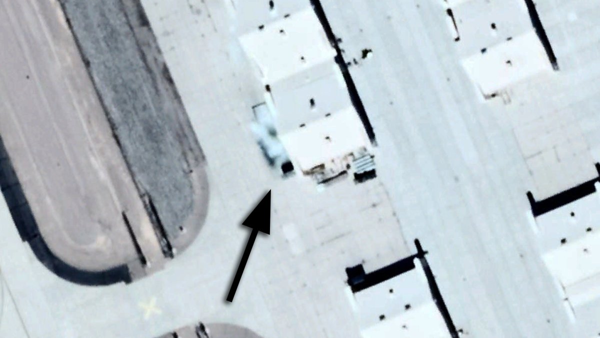
Just as the F-117 lived in total darkness at the base for nearly a decade, most of what is flying out of there now is also very likely to use the cloak of night to ensure its own anonymity. That’s why it’s very peculiar to come upon the satellite imagery posted at the top of this article and below. The image is apparently part of a recent update to Google Earth and other mapping sites. It shows a craft sitting just outside one of the end hangars that make up the rows of 54 similar hangars arrayed across the north side of the base, also referred to as ‘canyons’ in Tonopah and F-117 vernacular.
The image is interesting on two levels. First off, what exactly are we looking at? It’s hard to tell, but it certainly looks like an aircraft. To us it resembles a flying wing and is very similar to the RQ-170’s planform. The light color would also match. The only difference is that this aircraft appears to have a wingspan approaching 80 feet, which is significantly larger than that of the RQ-170 . So in that sense, this aircraft would be somewhere between an RQ-170 and the P175 Polecat in terms of proportions. This is the size of vehicle that we have posited to have existed for some time—a ‘Super Sentinel’ of sorts that is capable of performing strike and electronic attack missions.
The openings to the southern portion of canyon hangars at Tonopah are roughly 90 feet wide, so they can accommodate a fairly large flying-wing drone. But once again, although we can guess, it’s impossible to assign an exact ID to the vehicle. As to why brings us to the second major reason why this image is significant—it has been edited.
The photo, dated Oct. 1, 2017 and attributed to Digital Globe, has clearly been touched-up to conceal the details of the aircraft seen in front of the hangar. Usually, personnel at sites that work with sensitive hardware like secret aircraft are very aware of the schedules of imaging satellites that pass overhead. Test schedules and even the movement of an aircraft from one hangar to another can be dictated by the satellites’ predictable orbital paths. But no system is perfect and the need to conceal test articles or even semi-operational aircraft from overhead view is also dictated by the sensitivity of the asset. We have no idea what exactly happened here, but clearly, corrective action was taken after the satellite’s shutter had snapped open and close.
Interestingly enough, another satellite image that was taken in July 2016 also shows indications of being doctored to conceal an aircraft sitting in front of the same hangar. In this case, the anomaly looks like it could be a MiG-29. The extrapolated wingspan of that blurry craft matches the Soviet era twin-engined fighter. Still, this is just a guess, as there is very little visual information to work off of.
The RQ-170 has been photographed in satellite imagery before. I actually wrote a post on just that back in 2015 . But when it comes to images of Tonopah Test Range Airport on Google Earth, photos that were in the system seemed to have dropped off. Including ones that show a UH-60 Black Hawk around a hangar that has shown a lot of activity in recent years. But never before have we seen what appears to be a unique aircraft deliberately blurred in an image.
These revelations come as Motherboard has published a big story accusing Google of altering its mapping practices for national security reasons and in particular omitting updates of the range area just south of Tonopah Test Range Airport, which the contractor Sandia Corporation operates on behalf of Sandia National Laboratories. We’ve assessed Motherboard’s claims to be dubious at best and that area is not that secretive at all. It is primarily where nuclear bomb shapes are tested, but it also supports a rolling set of diverse tests for a range of ‘customers.’ Sandia has publicized the area’s purpose extensively even in their own video productions .
Initially, Motherboard’s piece claimed that there had been no updated imagery of the area in question within the Tonopah Test Range between 2008 and 2017. After publication, the authors added an update to note that Google had at some point added historical images of ‘the gap’ for both 2014 and 2015.
“Google Earth didn’t censor this area in Nevada. Our satellite imagery is licensed from third party providers which are commercially available and are not the property of Google,” a Google spokesperson subsequently told Motherboard , as well. “We update imagery by prioritizing areas that are most popular with users while complying with local and federal laws.”
It’s true that if you plug in the map coordinates the authors provided, 37o41’6.39″N, 116o39’57.31″W, it does indeed bring you to a location and altitude where there is only imagery for 2007, 2014, 2015, and 2017. However, the Motherboard story includes a picture of a much broader area with the caption “The Tonopah Gap.” This picture appears to reflect what you’d see from an altitude of approximately 8.7 miles up in Google Earth. Again, for this particular position, there are only previous images of that location for 2007, 2014, 2015, and 2017.
The central location of the “Tonopah Gap” as described in the Motherboard article., Google Earth
However, if you zoom out less than a mile more, there is historical imagery of very similar resolution of the same area for every year since 2007. In addition, while the “gap” the authors of the Motherboard piece identified at the dry lake bed might have been the longest, a cursory look at other locations around the Tonopah Test Range Airport show that there is similarly absent imagery at various altitudes and date ranges between 2007 and 2016. If you explore the imagery well outside of the sprawling Nevada Test and Training Range, which encompasses Tonopah, you’ll find similar ‘gaps’ in the utterly mundane and largely desolate Nevada desert.
This would make sense and lends weight to the statement from Google that it updates Google Earth’s imagery library based on its understanding of user demand. It also further calls into question whether there is any particular significance to the absence of imagery, and only at certain altitudes, of the dry lake beds near Tonopah. There’s no clear indication that Google avoided that particular area specifically or deliberately.
This innocuous piece of the Nevada Desert, at the coordinates 37o39’44.60″N, 117o08’12.39″W, situated 20 miles west of the “Tonopah Gap” has no imagery between 2006 and 2010, between 2010 and 2013, or between 2013 and 2016. This equals 8 years of missing imagery since 2006, the same total that is absent from Google’s library for the dry lake southeast of the Tonopah Test Range Airport. , Google Earth
Still, it is possible that there is some sort of censorship going on, as we also know that Google and/or its image providers have clearly censored specific locales in far more obvious ways, but it is more likely that they have not obtained or uploaded images of those particular areas for more benign reasons, as the company said in its statement. The team behind Google Earth was able to backfill images of the area in question without any apparent issue and it’s possible that they will add more shortly given the likely increase in interest in the area.
The Motherboard piece does go into some detail about how entire images are kept from the public. This is either through ‘shutter control,’ asking companies to not photograph an area at all, or via ‘buy-and-deny,’ wherein the U.S. Government buys exclusive rights to images and then sits on them. The United States has reportedly never once ordered an imagery provider to use shutter control.
Regardless, none of these mechanisms explains how individual objects get obscured or blurred in the images that do get released. That issue has been of major interest dating back to when the game-changing web tool was launched well over a decade ago.
Google spokesperson Deanna Yick told Mashable the following back in 2012:
“The satellite and aerial imagery in Google Earth and Google Maps is sourced from a wide range of both commercial and public sources… These third-party providers are required to follow the law of the countries in which they operate, so some of them may blur images and then supply us with those images. … We strive to publish the best data possible, and take into account many elements when determining which imagery is optimal, such as imagery date, resolution and clarity… We receive updated information from our data providers from time to time, and if those updates improve the imagery of the area based on all of those quality elements, we may elect to publish that updated imagery even if the provider has blurred certain regions of the image.”
“The satellite and aerial imagery in Google Earth and Google Maps is sourced from a wide range of both commercial and public sources… These third-party providers are required to follow the law of the countries in which they operate, so some of them may blur images and then supply us with those images.
We strive to publish the best data possible, and take into account many elements when determining which imagery is optimal, such as imagery date, resolution and clarity… We receive updated information from our data providers from time to time, and if those updates improve the imagery of the area based on all of those quality elements, we may elect to publish that updated imagery even if the provider has blurred certain regions of the image.”
So the real story here doesn’t appear to be located on the dry lakebed to the south Tonopah Test Range Airport, but instead at the airport itself where there is real evidence that images have been manipulated to obscure sensitive objects. If anything else, the doctored images of Tonopah Test Range Airport add more evidence to the fact that the base remains highly active when it comes to supporting operations of sensitive if not top-secret aircraft.
Contact the authors: tyler@thedrive.com and jtrevithickpr@gmail.com
Comments couldn’t be loaded. Please refresh the page.
作者:泰勒·罗戈韦和约瑟夫·特雷维西克
更新于美国东部时间2019年12月1日上午7:11
托诺帕试验场机场与秘密航空行动有着深厚的渊源。从冷战时期驻扎美国缴获的苏联战斗机部队,到F-117战斗机项目绝密作战时期的基地,再到该机型退役后又回到这里进行特殊的后续训练,这座基地一直吸引着航空航天爱好者的目光,尽管其影响力不及南部规模庞大、位置偏远且戒备森严的邻居——51区。
近年来,该基地曾部署过RQ-170“哨兵”隐形侦察无人机,以及外国防空系统和其他武器装备。此外,它还承担着特种作战飞机升级测试的发射场等功能。甚至有传言称,陆军“隐形鹰”直升机的后继机型也在此基地运行,而且外界普遍猜测,先进的无人系统,特别是无人作战飞行器(UCAV),目前也驻扎于此。事实上,如果说有哪个地方能够为一支规模虽小但高度机密的作战飞机部队提供支持,那非托诺帕莫属。
就像F-117战机在基地完全黑暗中服役近十年一样,现在从那里起飞的大多数飞机也极有可能利用夜幕来确保自身的隐蔽性。因此,看到本文开头和下方发布的卫星图像就显得格外奇怪。这张图像显然是谷歌地球和其他地图网站近期更新的一部分。图像显示,一架飞机停放在基地北侧排列的54座类似机库中,其中一座机库的末端机库外。在托诺帕和F-117的行话中,这些机库也被称为“峡谷”。
这张图片在两个层面上都很有意思。首先,我们看到的究竟是什么?很难说清楚,但它看起来确实像一架飞机。在我们看来,它类似于飞翼,与RQ-170的平面形状非常相似。浅色也吻合。唯一的区别是,这架飞机的翼展似乎接近80英尺,比RQ-170大得多。因此,从这个意义上讲,这架飞机的尺寸介于RQ-170和P175“臭鼬”之间。这正是我们推测已经存在一段时间的飞行器的尺寸——某种“超级哨兵”,能够执行打击和电子战任务。
托诺帕峡谷机库南侧的入口大约有90英尺宽,足以容纳相当大的飞翼无人机。但即便我们可以猜测,也无法确定这架无人机的具体型号。至于原因,这就引出了这张照片意义重大的第二个主要原因——它经过了编辑。
这张拍摄于2017年10月1日、署名为Digital Globe的照片显然经过了后期处理,以掩盖机库前飞机的细节。通常情况下,负责维护敏感设备(例如秘密飞机)的人员都非常清楚飞越上空的成像卫星的运行时间表。测试计划,甚至飞机从一个机库转移到另一个机库,都可能受到卫星可预测轨道的影响。然而,任何系统都不可能完美无缺,出于资产的敏感性考虑,有时也需要对测试设备甚至半运行状态的飞机进行遮蔽。我们并不清楚这里究竟发生了什么,但显然,在卫星快门打开和关闭后,相关人员采取了补救措施。
有趣的是,另一张摄于2016年7月的卫星图像也显示出被篡改的迹象,目的是掩盖停放在同一机库前的飞机。在这种情况下,异常物体看起来像是一架米格-29战斗机。根据推断,这架模糊飞机的翼展与苏联时代的双引擎战斗机相符。然而,这仅仅是一种猜测,因为可供参考的图像信息非常有限。
RQ-170 此前曾在卫星图像中出现过。事实上,我早在 2015 年就专门写过一篇博文介绍过它。但就谷歌地球上托诺帕试验场机场的图像而言,系统中的照片似乎有所减少。其中包括一些显示一架 UH-60 黑鹰直升机在近年来活动频繁的机库附近盘旋的照片。然而,我们从未见过一架似乎经过特殊处理、在图像中被故意模糊处理的独特飞机。
就在Motherboard发布一篇重磅报道,指责谷歌出于国家安全考虑更改地图绘制方式,特别是故意遗漏托诺帕试验场机场以南区域的更新信息之际,这些爆料也随之而来。该试验场由承包商桑迪亚公司代表桑迪亚国家实验室运营。我们认为Motherboard的说法充其量也只是值得怀疑,而且该区域根本算不上什么秘密。它主要用于核弹形状的测试,但也为众多“客户”进行各种滚动式测试。桑迪亚甚至在其制作的视频中也广泛宣传了该区域的用途。
最初,Motherboard 的文章声称,2008 年至 2017 年间,托诺帕试验场相关区域没有更新的图像。发表后,作者补充说明,谷歌在某个时候添加了 2014 年和 2015 年“缺口”的历史图像。
谷歌发言人随后也向Motherboard表示:“谷歌地球并未审查内华达州的这片区域。我们的卫星图像是从第三方供应商处获得授权的,这些图像是商业用途的,并非谷歌所有。我们会优先更新用户最感兴趣的区域的图像,同时遵守当地和联邦法律。”
确实,如果输入作者提供的地图坐标(北纬37°41′6.39″,西经116°39′57.31″),会找到一个只有2007年、2014年、2015年和2017年影像记录的位置和海拔。然而,Motherboard的文章中包含一张更广阔区域的图片,标题为“托诺帕山口”。这张图片似乎反映了在谷歌地球上大约8.7英里(约14公里)高空看到的景象。同样,对于这个特定位置,也只有2007年、2014年、2015年和2017年的影像记录。
Motherboard 文章中描述的“托诺帕峡谷”的中心位置,以及谷歌地球
然而,如果将视野缩小不到一英里,就能看到自2007年以来同一区域每年分辨率都非常相似的历史影像。此外,虽然Motherboard文章作者在干涸的湖床上发现的“影像空白”可能是最长的,但粗略查看托诺帕试验场机场周围的其他地点就会发现,在2007年至2016年间,不同高度和日期范围内都存在类似的影像缺失。如果将视野扩展到托诺帕所在的广袤的内华达州试验训练场之外,你会发现在极其单调且荒凉的内华达沙漠中也存在类似的“影像空白”。
这合情合理,也印证了谷歌的说法,即谷歌会根据用户需求更新其地球影像库。此外,这也进一步引发了人们的疑问:托诺帕附近干涸湖床的影像缺失,且仅在特定高度缺失,是否具有任何特殊意义?目前尚无明确迹象表明谷歌有意或刻意避开了该区域。
这片位于内华达沙漠、坐标为北纬37°39'44.60″、西经117°08'12.39″、距“托诺帕山口”以西20英里的不起眼区域,在2006年至2010年、2010年至2013年以及2013年至2016年期间均无影像记录。这意味着自2006年以来,该区域缺失了8年的影像,与谷歌地球中托诺帕试验场机场东南侧干涸湖泊的影像缺失时间相同。
尽管如此,也不排除存在某种审查的可能性,因为我们知道谷歌和/或其图片提供商曾以更为明显的方式审查过某些特定地点。但更有可能的是,正如该公司在声明中所说,他们没有获取或上传这些特定区域的图片是出于更为良性的原因。谷歌地球团队已经能够顺利地补全相关区域的图片,考虑到人们对该区域的关注度可能会增加,他们或许很快就会添加更多图片。
Motherboard 的文章详细介绍了如何阻止公众获取全部图像。这主要有两种方式:一是“快门控制”,即要求公司完全禁止拍摄特定区域;二是“购买并拒绝”,即美国政府购买图像的独家版权,然后将其束之高阁。据报道,美国从未命令任何图像提供商使用快门控制。
然而,这些机制都无法解释最终发布的图像中单个物体是如何被遮挡或模糊的。这个问题自十多年前这款具有变革意义的网络工具推出以来,就一直备受关注。
谷歌发言人迪安娜·伊克在2012年告诉Mashable网站以下内容:
“谷歌地球和谷歌地图中的卫星和航空影像来源于众多商业和公共渠道……这些第三方供应商必须遵守其运营所在国家/地区的法律,因此他们中的一些人可能会对影像进行模糊处理后再提供给我们。……我们力求发布尽可能最佳的数据,并在确定最佳影像时会考虑诸多因素,例如影像日期、分辨率和清晰度……我们会不时收到数据供应商的更新信息,如果这些更新能够提升该区域影像的质量,即使供应商对影像的某些区域进行了模糊处理,我们也会选择发布更新后的影像。”
“谷歌地球和谷歌地图中的卫星和航空图像来源于各种商业和公共资源……这些第三方供应商必须遵守其运营所在国家的法律,因此其中一些供应商可能会模糊图像,然后向我们提供这些图像。
我们力求发布尽可能最好的数据,并在确定最佳影像时考虑诸多因素,例如影像日期、分辨率和清晰度……我们会不时收到数据提供商的更新信息,如果这些更新能够根据所有这些质量要素改善该区域的影像,即使提供商对影像的某些区域进行了模糊处理,我们也可能选择发布更新后的影像。
因此,真正的事件似乎并非发生在托诺帕试验场机场南部的干涸湖床上,而是在机场本身。那里有确凿证据表明,图像被篡改以掩盖敏感物体。如果说还有什么意义的话,那就是这些被篡改的托诺帕试验场机场图像进一步证实了该基地在支持敏感甚至绝密飞机的运行方面仍然非常活跃。
联系作者:tyler@thedrive.com 和 jtrevithickpr@gmail.com
评论加载失败,请刷新页面。