Hornet Pilot’s Cold War Mission Left Him In The “Buffer Zone” Between East And West冷战时期,大黄蜂飞行员执行任务时被困在了东西方之间的“缓冲区”。
A quickly planned high-stakes training mission over Western Germany in bad weather saw a CF-18 pilot seek refuge in a very dangerous place.
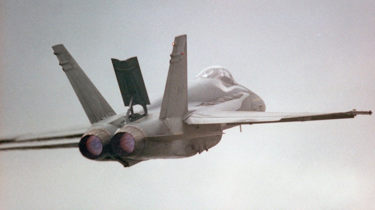
Published Feb 22, 2024 4:05 PM EST
Anidaat via Wikicommons (CC-SA-4.0)
“Okay guys, listen up. You have 30 minutes till you walk out the door. Here’s the mission scenario.”
Tom Sweeney, our Tactical Evaluator, set down the mission folder on the planning table in the bunker. My CF-18 Hornet squadron, 433 Escadron Tactique d’Appui de Combat (ETAC, a French-language unit in Canada’s Air Force), had deployed to Lahr, West Germany, to fly with our brethren who were stationed in theater, 75 km (45 miles) up the Autobahn in Baden-Soellingen.
Tom and I had gotten our pilots’ wings together eight years prior, but he had gone to fly CF-104 Starfighters in Germany while I was assigned to train pilots as an instructor in Moose Jaw, Saskatchewan. Finally, I was getting a chance to prove I could qualify as a combat-ready flight lead with NATO forces in Germany, almost a decade later.
I’d already qualified as a flight lead with NORAD, flying air defense missions in Canada from our home base in Bagotville, Quebec, and other deployed bases. Our squadron’s role as a ‘rapid reactor’ to reinforce NATO in wartime required us to be qualified in the European theater as well. Europe had its own entirely different sets of rules, and all of us had been to Germany to fly with Canadian squadrons based there to learn the ropes.
Now, as part of a squadron deployment, was essentially the final exam that would cap off our upgrade training. Today, Tom (“Sween”) was flying as number two, evaluating our Section lead, Richard “Dog” Duguay, myself as number three, an element lead, and another pilot as number four, my wingman. The flight test scenario was called a Tactical Evaluation, or ‘Tac Eval.’
Pilots from 433 Squadron in their deployed bunker, Lahr, West Germany. Today’s mission lead, Dog, has a towel under his arm. The planning map behind the two other pilots clearly shows the inter-German border. Dan McWilliams
NATO had a standard for the minimum time allowed to plan a ground attack mission. Naturally, these Tac Eval missions were predicated on doing things in the absolute minimum time, pushing us to the limit of what could be expected of us. Today we had about 30 minutes to plan, brief, and walk out the door of the bunker fully dressed for flight.
Sween was flying as number two in his role as an evaluator, and he was watching both Dog and me during the planning, flight, and debrief. The goal was for both of us to be certified as flight leads in Europe, and for number four to be evaluated as a ‘winger.’
Today’s scenario involved an attack on a NATO SAM (surface-to-air missile) site north of Frankfurt. This was a real missile site, which we were pretending was a Soviet installation for the purposes of the mission. The first order of business was to work backward from our assigned time on target (TOT) to see when we needed to take off, when to start engines, and how much time we had to plan and brief the mission.
Dog and I conferred over the target folder, quickly studying the pictures and 1:50,000 scale topographical maps. We devised which weapons to use, which axis to attack from, and how to egress without being shot down. All four of us, including Tom as our number two, were assigned tasks according to the Standard Operating Procedures (SOPs). We delved into the Joint Munitions Employment Manuals (JMEMs) to determine the number of weapons to be used to inflict maximum damage, while avoiding defenses and not being damaged by the exploding targets as we overflew them. The wingmen dug out the appropriate 1:500,000 scale maps and busied themselves drawing lines and restrictions on them. Even at speeds of seven to almost nine miles per minute, it would still take us almost half an hour to reach the target.
A flurry of planning ensued. We ended up with a plan to fly CRV-7 rocket attacks, each of us carrying four pods of 19 rockets (a total of 76 rockets per aircraft). These rockets could be fired from 9,000 to 12,000 feet away, and would hit the target supersonic. They had warheads that would penetrate and then fragment, destroying bunkers, antennae, and buildings, and killing any personnel on site. Of course, we didn’t actually carry and fire the rockets. We were going to use the CF-18’s onboard software to simulate the aiming and firing of the rocket pods.
With eight minutes until we had to walk out of the planning area to get dressed in our flying gear, it was almost briefing time. “Three minutes. Make copies and be ready” announced Dog. The wingers busied themselves with the color photocopier, making three copies of the master maps. Those maps were meticulously drawn using standard operating procedures colors and symbols. Waypoint numbers in blue, with blue circles. Distances in green, on the left sides of the track lines. Timings in black, on the right side of the tracks. Speed changes in red. Headings and track lines in black. There were mission data cards with all the waypoints, frequencies, carriage/release/jettison data and limiting speeds for the weapons and external fuel tanks. Chaff, flare, and jammer usage as well as code words and callsigns were also included.
While the wingers made the copies, Dog and I huddled again to share the elements of what each of us had been doing. “Time Hack. In 33 seconds, it will be 13:17 Zulu.” The last maps were passed around by the wingmen to the leads as we all organized our little patches on the planning table with the sheets of paper, and synchronized our watches. Mine was within a second, so I didn’t bother changing it.
Dog went through a ‘minimum time’ briefing format. Target information and plan was first, followed by threats and how to avoid them. Contingencies were covered, as were what to do if we were intercepted by other aircraft en route. Weather was a concern today, because there was some fog with limited visibility, and some rain showers, especially in the target area. Cloud ceilings were low, on the limit for what we could accept with Europe’s peacetime flying rules, but Dog had decided we were going to launch anyway. I could see Tom taking notes that obviously were passing some sort of judgment on those decisions. I had no idea if he was approving or disapproving, but I had no time nor did I have any capacity to fret about that.
The briefing ended with the typical “Everything else is SOP” directive. Our fighter wing in Europe, known as ‘4 Wing’ had a thick publication with all of their SOPs. They covered all aspects of flying operations, such as ground operations, radio calls required, terminology to be used, radar scan responsibilities by formation members, air-to-air (A/A) tactical air navigation (TACAN) frequencies, reaction to aerial or surface threats, radar sorting and shooting, rules of engagement (i.e. when to shoot or not to shoot), and many, many other items. In short, briefing items that would have taken up 20 to 30 minutes when we were going through basic fighter pilot training had been completely covered in that one phrase.
Part of what we were being evaluated on was our knowledge and application of SOPs. The exercise scenario was designed explicitly to force formation members to apply and adapt those SOPs to changing circumstances.
By now, the mundane details of getting dressed, signing out, and walking to the hardened aircraft shelters to start our aircraft were old hat. I was mostly preoccupied with visualizing the routing, my actions, and how to make an effective attack.
A Tech from 433 helps a pilot get strapped in inside a HAS for a tactical training mission in Europe. Dan McWilliams
The route to the target area started out fairly simple. We were to pass just to the east of Frankfurt at low altitude, parallel to the East German border, northbound. After passing the airspace around one of Europe’s busiest civilian airfields, we’d swing northwest from Frankfurt to the target area. The egress was along the same path.
One particularity of the area east of Frankfurt was the proximity to Warsaw Pact airspace. We were flying underneath what was then a ‘buffer zone’ between East and West. At low altitude, there were no constraints – the buffer zone existed only 1,500 feet above ground. Above that in the buffer zone, there were special procedures for military aircraft, including transponder operation, flight paths, etc. In short, the idea was to avoid having a high-speed military aircraft flying toward East Germany, making Air Defense forces on the Soviet side nervous and thinking they were being attacked by NATO. Today’s weather conditions made the routing under the buffer zone unavoidable.
Two Hornets launch on a day like the one on which I flew my Tac Eval. Dim, murky, low cloud, and mediocre visibility. Photo Rafael Finter
We launched from the northbound runway, flying a carefully designed path that our own base’s air defenses would recognize. Groundspeeds, turning points, transponders, and other things were used to appear friendly to the twitchy fingers of friendly missile and gun batteries.
En route, out of the base’s air defense zone, we settled into an offset ‘card’ formation, accelerating to 420 knots (kts) groundspeed, or about 485 mph. In this formation, lead was in front, two was offset 1.5 nautical miles to his right, and I was about 30 seconds (3.5 to four miles) behind them. I offset my flight path a bit to the left of my lead’s, and my winger (number four) was off to my right side. For now, the visibility was looking reasonable, but not great. I knew that it would be dropping as we progressed further north.
Sween had us squawking the ‘please attack me’ transponder code for NATO peacetime practice. Sure enough, a couple of what turned out to be F-15s from the ‘American sector’ (Bitburg, Ramstein, and other USAF bases to the northwest of ours) came at us from our 10 o’clock, high. They were operating above the lowest cloud layer, so we never saw them, but lead and two prosecuted an attack on them, scoring simulated kills and avoiding being shot themselves (or so we liked to think).
The short engagement had slightly delayed us, so Lead called for us to ‘push it up to 510’ a bit earlier than planned. That meant we were traveling at 500 feet above ground, covering eight and a half nautical miles per minute (almost 600 mph). We were still well within our TOT window, but Dog wanted to be as precise as possible. Flying east of Frankfurt now, the cloud (ceiling) was getting gradually lower, and tendrils of cloud and fog were touching some of the rolling terrain in the area. Following SOP, we collapsed into an Arrow formation to weave our way through the gaps in the terrain, maintaining our minimum altitude above ground, and staying fairly close to our planned track. Luckily, given the poor weather forecast, we had already designed our route to pass through the lowest-altitude terrain in the area.
Before we knew it, we were approaching the target area. There was considerable fog caused by rain showers in the area, and visibility was marginal, and getting worse.
Imagine flying below low, scraggly clouds that almost touched the rolling hills, and only being able to see about 20 seconds ahead of the aircraft. The ‘pucker factor’ was rapidly increasing in all our cockpits.
I fudged my flight path a bit to the west of my planned line, where it wasn’t raining as hard, and the visibility was a bit better. I made sure my videotape was rolling to validate my weapons release on target, on time.
At about five miles from the target, I pulled my nose 45 degrees to the left, climbing to about 1,500 feet above ground. I was just skirting the base of the ragged clouds. I pulled back to the right where I could just make out the NATO missile site, hidden in the murky green forested area between two hills. I smiled as I pushed the ‘pickle’ button, registering my simulated rocket shot. I held the pickle for a full two seconds to make sure that all four pods would shoot their rockets, then hauled my aircraft into a 5-G horizontal pull, simulating chaff and flare ejection and voicing it to my tape so Sween would hear that I was doing it.
A missile site like the one we ‘attacked’ on this mission – only a far nicer day in Germany. This CF-18 is carrying the weapons load we simulated, four CRV-7 rocket pods. DND photo.
Phew. I was really afraid that we wouldn’t see the target, given the bad weather. Later, in the debrief, we reviewed everyone’s videotapes and saw that three out of four of us had ‘hit’ the target within 10 seconds of the planned timing. The only person who missed the target (he didn’t see it in time, and had to abort his attack) was our esteemed Evaluator, Tom Sweeney.
No, I didn’t gloat… Much! For now, though, I had no idea how it had gone. The priority was to reform the formation, and return to base. The weather was getting worse. Soon, I lost sight of lead in the murk, and he was only 3.5 miles ahead according to my air-to-air TACAN readout. I could see the blips from lead and two at the bottom of my radar screen, and I just followed my track line. Number four had closed in about one mile away, and he was barely visible in the foggy clag below the clouds.
Near a turning point, under the buffer zone, I was confronted by a wall of rain and fog. I looked to my right. Number four had disappeared from view beyond a small hill that was between our flight paths. I edged my aircraft slightly lower, but my radar altimeter (RADALT) went off. We were supposed to be at 500 feet Above Ground Level (AGL) minimum. I’d set my RADALT at 100 feet. Dang. Even at 100 feet AGL, there was no way I could get below the upcoming rain and fog. I looked ahead and up, and saw some slightly lighter areas within the strato-cumulus clouds above.
Screw it. I pulled my nose up aggressively, gaining altitude up to the minimum safe altitude for the sector, which happened to be above 1,500 AGL, solidly in the buffer zone. Frantically, I took several actions within seconds. I turned off my transponder. It would be a bad idea to announce to air traffic control and Strawbasket (NATO air defense radar) that I was flying within the buffer zone without authorization, in clouds, and at high speed (510 kts). I also slewed my radar scan to search anxiously just ahead, confirming there was no aerial traffic ahead for the next 30 miles or so. Luckily, there was normally no traffic in the buffer zone, with the exception of three corridors to and from Berlin.
I pushed my radar scan back down, and found lead and two. Still climbing, now through 5,000 feet, I was nowhere close to coming out of cloud.
I climbed higher, plugging in the afterburners briefly, and broke out on top of the fluffy clouds at almost 18,000 feet. I looked at my moving map. Wow, I was very close to the Eastern German border. I turned a bit to the right, to ensure I was not converging on it, and double-checked that my transponder was indeed off. My radar warning receiver was silent, meaning that no attack radars were tracking me on the Soviet side of the border.
I confirmed where the rest of my formation was, below the cloud, with my radar. Not bad. They were now seven miles ahead, because I’d lost a bit of position with the rapid climb. No radio calls yet, not from within the formation, and nothing on Guard (the emergency frequency).
I was praying that there would be no ‘Brass Monkey’ call. Brass Monkey was the code for a lost NATO aircraft, heading toward East Germany. If any NATO pilot heard that, the procedure was to immediately turn Westbound and confirm one’s position. The most likely cause was being lost, and that’s why NATO radars made a call on Guard and everyone, even those who thought they were okay, were to react.
Squinting down into the clouds below, I spotted a small gap and some green terrain. Yes! I chopped my throttles to idle, and locked up lead’s aircraft with my radar. This was a no-no during a tactical flight, but there was no way I could be making a steep descent through murky, cloudy, skies, while trying to keep track of lead’s radar blip in search mode.
If Dog mentioned it, I’d beg forgiveness in the debrief.
Keeping the patch of green ground in sight, I dove steeply, spiraling down through the tiny gap in the puffy clouds, extending the speed brake and pulling G in the spiral to keep my speed subsonic. As I dropped through 2,000 feet, I went below the cloud cover, and saw that I was now only five miles behind lead. I broke the radar lock, and looked to my right for number 4. There he was, only slightly ahead. I’d been out of sight of the formation for about 90 seconds, but it had seemed like an eternity. I turned my transponder back on, and pretended everything was normal.
Looking back over my shoulder, I could see a wall of fog and rain that the formation had just emerged from. Maybe they hadn’t seen what I’d done, I hoped.
The remainder of the flight was uneventful. I said absolutely nothing about my little excursion into forbidden airspace during the debrief. At the end, after Tom gave us some good feedback about some relatively minor areas to improve, he congratulated us on our successful qualifications. He stamped and signed our log books.
CF-18 Hornets taxiing in Lahr’s South Dispersal, during 433 Squadron’s deployment in 1989. Dan McWilliams
For the next week, until we finished our deployment and went back to Canada, I lived in fear that someone would invite me into a supervisor’s office to be asked just what the hell I was doing in the buffer zone.
It looked like I got away with it. I didn’t tell anyone about my buffer zone incursion for several years – it was something I was not proud of, and I was afraid of any possible repercussions. I can tell the story now, because all those air defense batteries that were poised to shoot me down if I went into East German territory are now NATO members, and friends.
Retired Major Dan McWilliams logged 3,200 hours over 20 years in the Canadian Air Force, flying the CT-114 Tutor, CF-5, T-33, and CF-18. A specialist in Electronic Warfare and software, he managed a group of engineers developing mission-critical software for the CF-18 and for CF-18 simulators. He later flew and instructed in the Challenger 604, tested full-mission simulators for military customers, managed a CF-18 mission training center, and taught at an aviation college.
Contact the editor: tyler@twz.com
Comments couldn’t be loaded. Please refresh the page.
发布于美国东部时间2024年2月22日下午4:05
Anidaat 来自维基共享资源 (CC-SA-4.0)
“好了,伙计们,听着。你们还有30分钟时间离开这里。任务场景如下。”
我们的战术评估员汤姆·斯威尼把任务文件夹放在掩体里的计划桌上。我的CF-18“大黄蜂”战斗机中队,加拿大空军第433战术支援作战中队(ETAC,一支法语部队),已经部署到西德拉尔,与驻扎在巴登-索林根战区的战友们一起飞行,巴登-索林根位于高速公路以北75公里(45英里)处。
八年前,我和汤姆一起获得了飞行员资格,但他去了德国驾驶CF-104星式战斗机,而我则被派往萨斯喀彻温省的穆斯乔担任飞行员教官。将近十年后,我终于有机会证明自己能够胜任北约驻德国部队的作战飞行指挥官一职。
我当时已经获得了北美防空司令部(NORAD)的飞行长资格,从位于魁北克省巴戈特维尔的基地以及其他部署基地出发,执行加拿大境内的防空任务。我们中队作为战时北约的“快速反应部队”,其职责也要求我们具备在欧洲作战的资格。欧洲的作战规则与北美截然不同,我们所有人都曾前往德国,与驻扎在那里的加拿大中队一起飞行,学习相关技能。
这次飞行测试是中队部署的一部分,实际上是我们升级训练的最终考核。今天,汤姆(“斯威恩”)担任二号飞行员,负责评估我们的分队队长理查德·“狗”·杜盖、我(三号飞行员,小队队长)以及我的僚机(四号飞行员)。这次飞行测试场景被称为战术评估,或简称“Tac Eval”。
驻扎在西德拉尔的第433中队飞行员们在掩体中。今天的任务指挥官“狗”胳膊下夹着一条毛巾。另外两名飞行员身后的作战计划图清晰地标示着德国的边界。丹·麦克威廉姆斯
北约对地面攻击任务的计划时间有最低标准。自然,这些战术评估任务的前提是在绝对最短时间内完成任务,将我们推向极限。今天,我们只有大约30分钟的时间来制定计划、进行简报,然后全副武装地走出掩体准备飞行。
斯温作为评估员,担任二号飞行员,他在计划、飞行和飞行后总结过程中都观察着我和道格。我们的目标是让我们俩都获得欧洲飞行领队的资格认证,而四号飞行员则接受“僚机”的评估。
今天的演习场景是攻击位于法兰克福北部的一个北约地对空导弹阵地。这是一个真实的导弹阵地,为了任务需要,我们将其伪装成苏联的设施。首要任务是根据预定的到达目标时间(TOT)倒推,确定何时起飞、何时启动引擎,以及我们有多少时间进行任务计划和简报。
我和道格一起研究目标文件夹,快速浏览图片和1:50,000比例尺的地形图。我们商定使用哪些武器,从哪个方向发起攻击,以及如何在不被击落的情况下撤离。我们四个人,包括我们的副手汤姆,都根据标准作业程序(SOP)分配了任务。我们仔细研读了《联合弹药使用手册》(JMEM),以确定使用多少武器才能造成最大破坏,同时避开防御工事,并在飞越目标时避免被爆炸目标炸伤。僚机们翻出了相应的1:500,000比例尺地图,忙着在上面画线和划定限制。即使以每分钟7到近9英里的速度飞行,我们也需要将近半个小时才能到达目标。
随后我们迅速制定了计划。最终方案是使用CRV-7火箭弹进行攻击,每架飞机携带四个火箭弹巢,每个弹巢装有19枚火箭弹(每架飞机共76枚)。这些火箭弹可在9000至12000英尺的距离发射,并以超音速击中目标。它们的弹头能够穿透目标并碎裂,摧毁掩体、天线和建筑物,并杀死现场所有人员。当然,我们实际上并没有携带和发射这些火箭弹。我们将使用CF-18的机载软件来模拟火箭弹巢的瞄准和发射。
距离我们离开计划区换上飞行装备还有八分钟,简报时间也快到了。“三分钟。复印,准备。”“狗”宣布道。飞行员们忙着操作彩色复印机,复印了三份主航图。这些航图绘制得一丝不苟,使用了标准操作程序中的颜色和符号。航路点编号用蓝色标出,并附有蓝色圆圈。距离用绿色标出,位于航迹线的左侧。时间用黑色标出,位于航迹线的右侧。速度变化用红色标出。航向和航迹线用黑色标出。任务数据卡上记录了所有航路点、频率、武器和外挂油箱的挂载/释放/抛弃数据以及速度限制。此外,还包括箔条、干扰弹和干扰器的使用方法,以及代码和呼号。
僚机们复印地图的时候,我和道格又聚在一起,交流各自的任务进展。“时间速查。33秒后就是祖鲁时间13:17。”僚机们把最后几张地图传给长机,我们则在计划桌上整理各自的小臂章和纸片,并校准手表。我的手表时间只差一秒,所以我就没再调。
狗接受了“最短时间”简报。首先是目标信息和计划,然后是威胁以及如何规避。简报还涵盖了各种突发情况,以及如果途中被其他飞机拦截该怎么办。今天的天气令人担忧,因为有雾,能见度有限,而且还有一些阵雨,尤其是在目标区域。云层很低,几乎达到了欧洲和平时期飞行规则允许的极限,但狗决定无论如何都要起飞。我看到汤姆在做笔记,显然他在对这些决定做出某种判断。我不知道他是赞同还是反对,但我既没时间也没精力去纠结这些。
简报以一句典型的“其他一切都是标准操作程序(SOP)”结束。我们驻扎在欧洲的战斗机联队,也就是所谓的“第4联队”,有一本厚厚的手册,里面列出了所有的标准操作程序。这些程序涵盖了飞行行动的方方面面,例如地面作战、所需的无线电通话、使用的术语、编队成员的雷达扫描职责、空对空战术空中导航(TACAN)频率、对空中或地面威胁的反应、雷达定位和射击、交战规则(即何时开火或不开火)等等。简而言之,在我们接受基础战斗机飞行员训练时需要20到30分钟才能讲完的内容,现在只用了一句话就全部涵盖了。
此次评估的内容之一是我们对标准操作规程(SOP)的了解和运用。演习场景的设计旨在迫使编队成员根据不断变化的情况应用和调整这些标准操作规程。
到现在,穿衣、签到、走到加固的飞机掩体启动飞机这些琐碎的细节都已司空见惯。我当时满脑子想的都是航线、我的行动以及如何才能发起有效的攻击。
来自433中队的技师正在帮助一名飞行员系好高空飞行器(HAS)的安全带,准备执行在欧洲进行的战术训练任务。丹·麦克威廉姆斯
前往目标区域的航线起初相当简单。我们将低空飞越法兰克福以东,与东德边境平行,向北飞行。飞越欧洲最繁忙的民用机场之一周围的空域后,我们将从法兰克福向西北方向转向目标区域。撤离路线与返程路线相同。
法兰克福以东地区的一个特殊之处在于它靠近华沙条约组织的空域。我们当时正飞越东西德之间的“缓冲区”。低空飞行没有限制——缓冲区距离地面仅1500英尺。但在缓冲区上方,军用飞机则需遵守特殊程序,包括应答器操作、飞行路线等等。简而言之,这样做的目的是为了避免高速军用飞机飞向东德,以免引起苏联防空部队的紧张情绪,误以为遭到北约攻击。今天的天气状况使得我们不得不绕道缓冲区。
两架“大黄蜂”战斗机在和我进行战术评估飞行那天一样的天气里起飞。光线昏暗,云层低垂,能见度一般。照片由拉斐尔·芬特拍摄。
我们从北向跑道起飞,飞行路线经过精心设计,确保己方基地的防空系统能够识别。地速、转弯点、应答器以及其他一些细节都经过精心设置,力求在友军导弹和炮兵阵地等敏感单位的监视下显得友好。
飞出基地防空区后,我们组成了一个错位“卡片”队形,加速到420节(kts)地速,约合485英里/小时。在这个队形中,长机在前,二号机在他右侧1.5海里处,我则在他们后方约30秒(3.5到4英里)处。我的飞行路线略微偏左,我的副驾驶(四号机)则在我右侧。目前,能见度尚可,但并不算好。我知道随着我们继续向北飞行,能见度会越来越差。
斯温让我们模拟北约和平时期演习中的“请攻击我”应答器代码。果然,几架后来被证实是来自“美国区域”(比特堡、拉姆施泰因以及我们西北方向的其他美国空军基地)的F-15战斗机从我们10点钟方向的高空向我们袭来。它们在最低云层之上飞行,所以我们始终没有看到它们,但长机和副机对它们发起了模拟攻击,取得了一些击落战果,并且自己也躲过了攻击(至少我们是这么认为的)。
短暂的交战稍微耽误了我们的时间,所以领队要求我们比原计划提前一点“提升到510”。这意味着我们以离地500英尺的高度飞行,每分钟飞行8.5海里(接近600英里/小时)。我们仍在预定的飞行时间范围内,但领队希望尽可能精确。现在我们正飞越法兰克福以东,云层(云底高度)逐渐降低,云雾的丝丝缕缕触及了该区域起伏的地形。按照标准操作程序,我们组成箭形队形,穿梭于地形的缝隙之间,保持最低离地高度,并基本沿着预定航线飞行。幸运的是,考虑到糟糕的天气预报,我们已经设计好了航线,避开了该区域海拔最低的地形。
不知不觉中,我们已经接近了目标区域。由于该地区阵雨,雾气弥漫,能见度很低,而且还在不断恶化。
想象一下,飞机在低矮稀疏的云层下飞行,云层几乎触及连绵起伏的山丘,能见度只有飞机前方大约20秒。我们所有飞行员的驾驶舱内,紧张感都迅速上升。
我稍微调整了飞行路线,向西偏离了原计划,那里的雨势较小,能见度也更好一些。我确保录像机一直在运转,以便验证武器是否按时精准投放到目标上。
距离目标大约五英里时,我将机头向左拉了45度,爬升到离地约1500英尺的高度。我当时正掠过参差不齐的云层底部。我向右拉回机头,勉强能看到北约导弹发射场,它隐藏在两座山丘之间阴暗的绿色森林中。我按下“发射”按钮,模拟发射火箭,脸上露出了笑容。我按住“发射”按钮整整两秒钟,确保四个发射吊舱都能发射火箭,然后将飞机拉入5G的水平过载,模拟箔条和干扰弹的喷射,并对着录音机大声喊叫,好让斯温听到我的操作。
就像我们在这次任务中“攻击”的那个导弹发射场一样——只不过这次是在德国,天气要好得多。这架CF-18战斗机携带了我们模拟的武器载荷:四个CRV-7火箭发射巢。加拿大国防部照片。
呼,还好。天气这么糟糕,我真担心我们看不到目标。后来在任务总结会上,我们查看了每个人的录像,发现我们四个人中有三个在预定时间10秒内击中了目标。唯一一个没击中目标(他没来得及看到目标,不得不中止攻击)的是我们尊敬的评估员汤姆·斯威尼。
不,我并没有沾沾自喜……真的!不过,现在我完全不知道情况如何。当务之急是重新编队,然后返回基地。天气越来越糟。很快,我就在浓雾中失去了领队飞机的踪迹,根据我的空对空TACAN读数,他当时只在前方3.5英里处。我能看到雷达屏幕底部领队飞机和二号机的信号,于是我继续沿着航线飞行。四号机已经接近到大约一英里外,在云层下方的浓雾中几乎看不见。
在接近转弯点、缓冲区下方时,我遭遇了一堵雨雾墙。我向右望去,四号机已经消失在航线之间的一座小山后。我略微降低了飞机高度,但雷达高度表(RADALT)却响了。我们本应保持至少500英尺的离地高度(AGL)。而我把雷达高度表设定在了100英尺。糟糕!即使高度只有100英尺,我也无法越过即将到来的雨雾。我抬头望去,看到上方层积云中有一些颜色稍浅的区域。
管他呢。我猛地拉起机头,爬升到该区域的最低安全高度,正好在离地1500英尺以上,稳稳地待在缓冲区内。我慌乱地在几秒钟内采取了几个措施。我关掉了应答器。如果告诉空中交通管制和“草篮”(北约防空雷达)我未经授权在缓冲区内飞行,而且还在云层中以510节的速度飞行,那可就糟了。我还调转雷达扫描方向,焦急地搜索前方,确认接下来大约30英里内没有其他飞机。幸运的是,缓冲区内通常没有飞机,除了往返柏林的三个航线。
我把雷达扫描范围缩小,发现了前方两架敌机。飞机仍在爬升,现在已经超过5000英尺,但我离冲出云层还很远。
我继续爬升,短暂地开启了加力燃烧室,冲破了蓬松的云层,高度接近18000英尺。我看了看移动地图。哇,我离东德边境非常近了。我稍微向右转弯,确保没有逼近边境,并再次确认应答器确实已关闭。我的雷达告警接收器处于静默状态,这意味着苏联一侧的攻击雷达没有追踪到我。
我用雷达确认了编队其他飞机的位置,它们都在云层下方。还不错。由于快速爬升导致我位置有所偏移,它们现在领先我七英里。无线电里还没有消息,编队内部没有,紧急呼叫频率(守卫频率)上也没有任何动静。
我当时祈祷不要听到“黄铜猴子”的呼叫。“黄铜猴子”是北约飞机迷路、飞往东德方向的暗号。如果任何北约飞行员听到这个呼叫,程序是立即转向西飞并确认自身位置。最可能的原因是飞机迷路了,所以北约雷达会发出警戒呼叫,所有人,即使是那些自认为安全的人,都必须做出反应。
我眯着眼向下望去,看到云层下有一小片空隙和一片绿色的地面。太好了!我立刻将油门降至怠速,并用雷达锁定了领头机的飞机。这在战术飞行中是绝对禁止的,但我不可能在阴云密布的天空中陡然下降,同时还要在搜索模式下追踪领头机的雷达信号。
如果 Dog 提到了这件事,我会在事后汇报中请求原谅。
我始终注视着那片绿色的地面,陡然俯冲,螺旋式地穿过蓬松云层间的狭小缝隙,展开减速板,并在螺旋中承受过载,以保持亚音速飞行。下降到2000英尺后,我飞到了云层下方,发现自己只落后领头机五英里。我解除了雷达锁定,向右看去,寻找4号机。他就在那里,略微领先。我离开编队大约90秒,但感觉却像过了一个世纪那么漫长。我重新打开应答器,假装一切正常。
回头望去,我看到那队人刚刚从一片雾雨中走出来。我希望他们没看到我刚才做的事。
剩下的飞行旅程一切顺利。在飞行后总结会上,我完全没有提及我那次误入禁飞区的经历。最后,汤姆就一些需要改进的小地方提出了一些有益的反馈意见,并祝贺我们顺利通过资格认证。他还在我们的飞行日志上盖章签名。
1989年,第433中队部署期间,CF-18“大黄蜂”战斗机在拉尔空军基地南侧停机坪滑行。丹·麦克威廉姆斯摄
接下来的一个星期,直到我们结束部署返回加拿大,我一直生活在恐惧之中,害怕有人会把我叫到主管办公室,问我到底在缓冲区里干什么。
看起来我侥幸逃脱了。我好几年都没跟任何人提起过我闯入缓冲区的事——我并不为此感到骄傲,也害怕任何可能的后果。现在我可以讲这个故事了,因为那些原本准备在我进入东德领土时击落我的防空部队,现在都成了北约成员国,成了我的朋友。
退役少校丹·麦克威廉姆斯在加拿大空军服役20年,累计飞行3200小时,驾驶过CT-114 Tutor、CF-5、T-33和CF-18等机型。他是一位电子战和软件专家,曾领导一个工程师团队,负责开发CF-18及其模拟器的关键任务软件。之后,他还驾驶和教官驾驶过挑战者604教练机,为军方客户测试过全任务模拟器,管理过CF-18任务训练中心,并在航空学院任教。
联系编辑:tyler@twz.com
评论加载失败,请刷新页面。