Researchers home in on origins of Russia’s Baltic GPS jamming研究人员聚焦俄罗斯波罗的海GPS干扰的起源
Analysts have been tracking Russian electronic warfare from across the Gdańsk Bay, pinpointing familiar sites in Kaliningrad.
THE HAGUE, Netherlands — Polish researchers have collected detailed information on Russia’s Baltic Sea GPS jamming operations, a mysterious nuisance for aviators and mariners in the region that began when Russia attacked Ukraine.
The airwaves over the Baltic Sea have been compromised ever since the war began. In the past years, thousands of planes and ships have had their navigation systems bamboozled, with some ending up veering off course or even needing to cancel their trips altogether. The culprit behind these mysterious aberrations: radio waves emanating from secretive facilities run by Russia’s military.
Global Navigation Satellite System interference, which comes in the forms of jamming, which means blocking the signal, and spoofing, which entails gaming location readouts, has become a daily occurrence in northeastern Europe. From the airport of Gdansk through the busy shipping lanes of the Baltic Sea and all the way to the airspace of Estonia and Finland, these interferences have been recorded almost daily since Russia’s full-scale invasion of Ukraine in February 2022. They have even resulted in flight cancellations, airport closures and commercial ships steering off track.
Authorities in the Baltic states have laid the blame squarely on Russia. In March, eight European countries, including the Baltic states, Finland, Poland, France, the Netherlands and Ukraine, lodged a complaint with the UN about the practice. Several UN agencies have also taken up the issue, including the International Maritime Organization, the civil aviation authority ICAO and the International Telecommunications Union.
For its part, Russia – itself a Baltic Sea country and with part of its territory heavily affected by the jamming – has maintained official radio silence on the topic.
Open-source data and information released by governments in the Baltic states give some clues as to where these malicious signals might originate from. Two hotspots continuously pop up: Kaliningrad, Russia’s exclave wedged between Poland and Lithuania, and the St. Petersburg area. Both regions known to have a heavy Russian military presence, including divisions specialized in electronic warfare and radio.
This map approximates the trajectory of Russian GNSS jamming emanating from Baltiysk, Kaliningrad, on March 29, 2025. (Gdynia Maritime University, the University of Colorado, Maritime Office at Gdynia)
“People have gotten so used to having satellite navigation,” said Jaroslaw Cydejko, adjunct assistant professor at Gdynia Maritime University. “Mariners should be able to navigate without it, but it has become a fact of life.”
Cydejko’s work focuses on GNSS use in the maritime domain. Traditionally working “on the brighter side of GNSS,” in the past few years, much of his research has pivoted to examining the mysterious emissions interfering with the satellites’ signals in the Baltic.
Russia is employing both jamming and spoofing, although in 2025, the interference has shifted from blocking the signals primarily to falsifying them, Cydejko says, citing his research group’s observations. Spoofing is the more advanced technique, and is generally tougher to detect and defend against.
“Interfering with GNSS signals is, unfortunately, very easy,” said Ralf Ziebold, who is the head of the German Aerospace Center’s nautical systems department, housed in the institute of communications and navigation. Jamming is achieved by overpowering the weak signals originating from the global positioning satellites 20,000 kilometers above Earth’s surface, with radio signals emitted closer to home. Spoofing takes it one step further, by replacing the real signals with fakes that make it look like the receiver is somewhere it isn’t – and so can trick autopilots or captains to veer off course.
GNSS includes the United States’ GPS, Europe’s Galileo, and Russia’s GLONASS constellations, among others. The concept of GNSS interference has been a core component of electronic warfare for decades.
Cydejko, the Polish GNSS expert, is part of an international team of researchers that have worked to track the GNSS interference and determine its origin. They have set up several monitoring stations around the Gdańsk Bay and kept a close eye on the transmissions. The network became operational this year, just in time for a new wave of GNSS attacks.
Gdansk is not constantly affected by Russian jamming and spoofing, Cydejko said. Rather, the activities present a sporadic – although “annoying” and sometimes persistent – nuisance. The behavior shows that Russia is not, as some have suggested, using ship- or satellite-based transmitters against the Polish harbor city. This is confirmed by using his project’s listening posts to triangulate the origins of the signals.
The triangulations, which were conducted in the spring of this year and have been made available to Defense News, pinpoint two coastal locations in Russia’s Kaliningrad exclave with a precision of about one kilometer. Both are in close proximity to known electronic warfare units and military antenna sites.
This screenshot shows an example of the localization results of the source of GNSS interference on May. 4, 2025, with clusters of vessels indicating a falsified reading. (Gdynia Maritime University, the University of Colorado, Maritime Office at Gdynia)
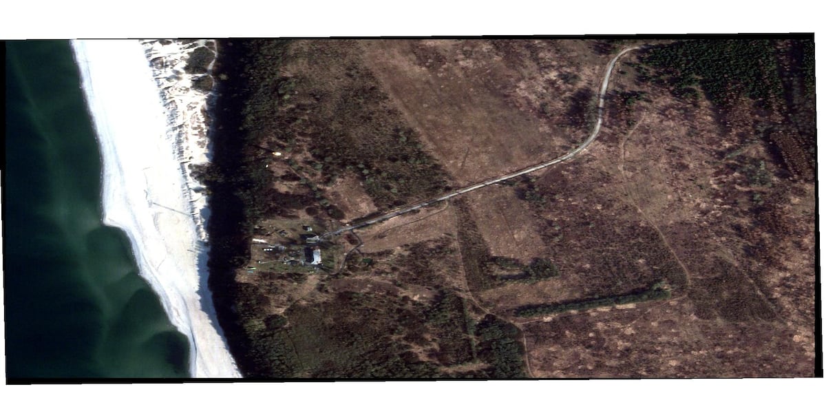
A spoofing attack in May and a jamming attack in April both originated from the vicinity of the Okunevo antenna site on the central Kaliningrad coast. Beyond the permanent antenna installations there, it is an area that is known to have hosted electronic warfare units in the past, including ones designed to interfere with GNSS.
The GT-01 Murmansk-BN system, a set of trucks with powerful, 32-meter tall antennas designed to jam communications systems in a radius of 5,000 to 8,000 kilometers, is visible here in satellite images taken in September and October 2018, underscoring the location’s military use and precedent of jamming operations. The site is also just a few driving minutes away from the headquarters of a significant Russian electronic warfare unit, which open sources identify as the 218th Independent Electronic Warfare regiment.
A jamming attack in March was triangulated to the harbor town of Baltiysk, which is also home to the Russian Baltic Fleet and its electronic-warfare complex, a military facility packed with antennas and mobile EW units, although the triangulation appeared to resolve to a point southwest of the city, closer to the harbor.
GPS jammers and spoofers can be very small, even those with a large range, and might be easily overlooked in satellite imagery. Ziebold, the German researcher, said his team had purchased jammers the size of a shoe box that had a range of many kilometers.
This also means that they can be mobile. The jammer that has been plaguing Estonia, for example, appears to have moved from southwest of Saint Petersburg to northwest of the city.
This emerges from data shared by open-source intelligence researcher @auonsson, who is part of a network of social media activists examining the jamming saga on a technical level. The person behind the social media handle spoke Defense News on the condition of remaining anonymous.
Auonsson used aircraft-transmitted data to create a heatmap of possible jammer locations around Russia’s imperial city. The flight information transmitted by planes and used for live airplane tracker maps also contains information about the quality of GPS data; when an aircraft’s GPS quality suddenly drops, this suggests that a jammer has come up over the plane’s horizon. By plotting the horizons of thousands of flights when they first encountered jamming, a heat map can be created, allowing for an approximate idea of where the offending transmitter might be located. The source code for this experiment is available on GitHub, and the data on which the investigation is based is publicly available.
“I don’t consider the exact source very relevant for the public discussion,” the person behind the @auonsson handle said. “The country is, though,” they added, referring to Russia.
Jamming to what end?
Estonia, Lithuania, Latvia, Sweden and Germany have all officially declared the GNSS interference over this busy stretch of Europe as a form of Russian hybrid warfare. They have described it as a deliberate, malicious act with the intent to cause disruption – “a hybrid action to disrupt our lives and to break all kinds of international agreements,” as the Estonian foreign minister Margus Tsakhna put it.
Not all agree with this interpretation. Jamming around military facilities is commonplace, especially for countries at war, Cydejko, of Gdynia Maritime University, pointed out. He thinks the interference over the Baltic Sea and in neighboring NATO states is largely collateral, not the point of the operation.
Gdansk is far enough away from Kaliningrad that it should not be affected by GNSS interference from the exclave, as it lies behind the horizon. Indeed, it is intermittently affected, which has puzzled researchers. Cydejko’s working hypothesis is that this may be the result of atmospheric conditions.
“Probably this jammer is working constantly, but we are getting a signal at one time or another simply because of the weather,” he said. He was watching the spoofing on his equipment one warm day, he said, when a weather front moved through, bringing wind, rain and a temperature drop. As it got cold, the spoofing abruptly ended. Similarly, Gdansk had a reprieve from the signals over the winter, but they picked back up in springtime and are commonplace currently.
Because the malicious signals travel in direct line of sight, flights are affected at a greater distance from the transmitter than a ship at sea level. This is why GPS jamming maps, which are based on aircraft data, show a much larger area as being affected than might be the case on the ground.
Indeed, ships likely are not the target of the interference, according to researchers. “It’s electronic warfare with the aim of preventing being hit by things that use satellite navigation – drones,” said Ziebold of the German Aerospace Center DLR.
Mariners and pilots should be able to navigate without GPS, according to Cydejko. Indeed, there are backup systems ranging from old-fashioned naval maps and binoculars to inertial positioning systems on aircraft. More advanced GPS receivers can also be resistant against a certain degree of jamming and spoofing, for instance by using antenna arrays or factoring in the direction of the signal.
There are some particularly vulnerable spots, such as Tartu’s airport, which has used exclusively GPS-dependent landing systems. The Estonian city’s airport faced flight cancellations and several re-routings as a consequence of GPS jamming; Finnair suspended flights there from April through May 2024.
Meanwhile, Ziebold’s team is deploying a modern incarnation of an old technology in the form of R-Mode Baltic. Instead of relying on satellite signals, it functions with existing land-based beacons. Ships equipped with Ranging Mode receivers can then calculate their position by measuring distances to multiple land-based stations, rather than relying on weak or erroneous satellite signals. The project, which receives EU funding, is being worked on by Germany, Poland, Sweden, Norway, Finland and Estonia, with Denmark as an associate partner.
Ziebold said the program is expanding to the aastern Baltic region, “where they have worse symptoms,” with stations currently being set up in Finland and Estonia. Germany’s DLR is taking the lead in the project, aiming to provide a pre-operational service to the countries’ national maritime authorities by 2026.
Several other countries are working on similar projects. The U.K. has become the first to deploy a land-based technology operationally in the form of the eLoran (Enhanced Long Range Navigation) system, which operates in low frequencies of 90 to 100 kHz and has been running since 2014. South Korea, frequently plagued by North Korean jamming attacks, is also actively developing an eLoran equivalent, while Russia, China, Saudi Arabia, India and the U.S. are all at varying stages of development for their own terrestrial navigation systems.
Linus Höller is Defense News' Europe correspondent and OSINT investigator. He reports on the arms deals, sanctions, and geopolitics shaping Europe and the world. He holds master’s degrees in WMD nonproliferation, terrorism studies, and international relations, and works in four languages: English, German, Russian, and Spanish.
荷兰海牙——波兰研究人员收集了有关俄罗斯在波罗的海进行GPS干扰行动的详细信息。这种神秘的干扰行动始于俄罗斯袭击乌克兰,给该地区的飞行员和海员带来了困扰。
自战争爆发以来,波罗的海上空的无线电波一直受到干扰。过去几年里,成千上万架飞机和船舶的导航系统遭到破坏,一些甚至偏离航线,或者被迫取消行程。造成这些神秘异常的罪魁祸首是:来自俄罗斯军方秘密设施的无线电波。
全球导航卫星系统(GNSS)干扰,包括信号干扰(即阻断信号)和欺骗(即篡改位置信息),在东北欧已成为司空见惯的现象。从格但斯克机场到波罗的海繁忙航道,再到爱沙尼亚和芬兰的领空,自2022年2月俄罗斯全面入侵乌克兰以来,几乎每天都有此类干扰事件发生。这些干扰甚至导致航班取消、机场关闭以及商船偏离航线。
波罗的海三国当局已将责任完全归咎于俄罗斯。今年3月,包括波罗的海三国、芬兰、波兰、法国、荷兰和乌克兰在内的八个欧洲国家就此做法向联合国提出申诉。包括国际海事组织、国际民航组织和国际电信联盟在内的多个联合国机构也已介入此事。
俄罗斯本身也是波罗的海沿岸国家,其部分领土受到干扰的严重影响,但俄罗斯方面对此事一直保持官方沉默。
波罗的海三国政府发布的开源数据和信息为我们提供了一些线索,帮助我们了解这些恶意信号的可能来源。有两个热点地区不断涌现:俄罗斯飞地加里宁格勒(位于波兰和立陶宛之间)以及圣彼得堡地区。众所周知,这两个地区都驻扎着大量俄罗斯军队,其中包括专门从事电子战和无线电通信的部队。
此图大致显示了2025年3月29日从加里宁格勒州波罗的斯克发出的俄罗斯GNSS干扰的轨迹。(格丁尼亚海事大学、科罗拉多大学、格丁尼亚海事办公室)
“人们已经非常习惯使用卫星导航了,”格丁尼亚海事大学兼职助理教授雅罗斯瓦夫·齐德伊科说。“航海员应该能够在没有卫星导航的情况下航行,但这已经成为现实。”
Cydejko的研究重点是全球导航卫星系统(GNSS)在海事领域的应用。他以往的研究方向主要集中在GNSS的积极方面,但近几年来,他的大部分研究都转向了对波罗的海地区干扰卫星信号的神秘辐射的调查。
俄罗斯同时采用了干扰和欺骗两种技术,但据西德伊科(Cydejko)援引其研究团队的观察结果称,到2025年,干扰手段将主要从阻断信号转向伪造信号。欺骗技术更为先进,通常也更难检测和防御。
“不幸的是,干扰全球导航卫星系统(GNSS)信号非常容易,”德国航空航天中心通信与导航研究所下属航海系统部门负责人拉尔夫·齐博尔德说道。干扰的原理是用距离地球更近的无线电信号压制来自2万公里高空全球定位卫星的微弱信号。欺骗技术更进一步,它用伪造的信号替换真实信号,使接收器看起来像是位于其他地方——从而欺骗自动驾驶仪或船长,使其偏离航线。
全球导航卫星系统(GNSS)包括美国的GPS、欧洲的伽利略和俄罗斯的格洛纳斯等卫星导航系统。GNSS干扰的概念几十年来一直是电子战的核心组成部分。
波兰GNSS专家西德伊科是国际研究团队的成员之一,该团队致力于追踪GNSS干扰并确定其来源。他们在格但斯克湾周围设立了多个监测站,密切监控信号传输。该监测网络于今年投入使用,恰逢新一轮GNSS攻击来袭。
西德伊科表示,格但斯克并非持续受到俄罗斯干扰和欺骗活动的影响。相反,这些活动只是偶尔出现,虽然“令人恼火”,有时甚至持续不断,造成不便。这种行为表明,俄罗斯并没有像某些人所说的那样,利用舰载或卫星发射器攻击这座波兰港口城市。他的项目利用监听站对信号来源进行三角定位,证实了这一点。
今年春季进行的三角测量结果已提供给《防务新闻》,测量结果以约一公里的精度确定了俄罗斯加里宁格勒飞地上的两个沿海地点。这两个地点都靠近已知的电子战部队和军事天线阵地。
此截图显示了2025年5月4日GNSS干扰源定位结果的示例,图中可见多艘船只聚集在一起,表明读数存在错误。(格丁尼亚海事大学,科罗拉多大学,格丁尼亚海事办公室)
5月份发生的欺骗攻击和4月份发生的干扰攻击均源自加里宁格勒中部沿海的奥库涅沃天线站附近。除了那里的永久性天线设施外,该地区过去也曾驻扎过电子战部队,其中包括一些旨在干扰全球导航卫星系统(GNSS)的部队。
2018年9月和10月拍摄的卫星图像显示,GT-01“摩尔曼斯克-BN”系统位于此处。该系统由多辆卡车组成,车上装有功率强大的32米高天线,旨在干扰半径5000至8000公里范围内的通信系统。这凸显了该地点的军事用途以及此前开展干扰行动的历史。此外,该地点距离俄罗斯一支重要的电子战部队总部仅几分钟车程,公开资料显示该部队是俄罗斯第218独立电子战团。
3 月份的一次干扰攻击被三角定位到港口城市波罗的斯克,该市也是俄罗斯波罗的海舰队及其电子战综合体的所在地,这是一个布满天线和移动电子战单元的军事设施,尽管三角定位似乎最终指向了该市西南方向、更靠近港口的一点。
GPS干扰器和欺骗器体积可以非常小,即使是那些作用范围很大的干扰器和欺骗器,也很容易在卫星图像中被忽略。德国研究员齐博尔德表示,他的团队曾购买过鞋盒大小的干扰器,其作用范围可达数公里。
这也意味着它们可以移动。例如,一直困扰爱沙尼亚的干扰器似乎已经从圣彼得堡西南方向移动到了该市西北部。
这些数据来自开源情报研究员@auonsson分享的信息。@auonsson是社交媒体活跃人士网络的一员,该网络正从技术层面研究此次干扰事件。这位社交媒体账号背后的用户在接受《防务新闻》采访时要求匿名。
奥恩森利用飞机传输的数据,绘制了俄罗斯皇城周边可能存在干扰器位置的热力图。飞机传输的飞行信息(用于实时飞机追踪地图)也包含GPS数据质量信息;当飞机的GPS信号质量突然下降时,表明干扰器已出现在飞机的视野范围内。通过绘制数千架次航班首次遭遇干扰时的视野范围,可以创建热力图,从而大致确定干扰发射器的可能位置。该实验的源代码已在GitHub上公开,调查所依据的数据也已公开。
“我认为具体的消息来源对公开讨论来说并不十分重要,”@auonsson 账号背后的用户说道。“但国家本身很重要,”他们补充道,指的是俄罗斯。
干扰到底是为了什么?
爱沙尼亚、立陶宛、拉脱维亚、瑞典和德国均已正式宣布,俄罗斯对欧洲这一繁忙区域的全球导航卫星系统(GNSS)干扰是俄罗斯发动的混合战争。他们将其描述为蓄意恶意行为,旨在造成混乱——正如爱沙尼亚外交部长马尔古斯·察赫纳所言,“这是一种旨在扰乱我们生活并破坏各种国际协议的混合行动”。
并非所有人都认同这种解读。格丁尼亚海事大学的西德伊科指出,干扰军事设施是司空见惯的事情,尤其是在交战国之间。他认为,干扰波罗的海及其周边北约国家很大程度上是附带的,并非行动的真正目的。
格但斯克距离加里宁格勒足够远,位于地平线以下,按理说不应受到这块飞地GNSS干扰的影响。然而,它却间歇性地受到干扰,这令研究人员感到困惑。Cydejko提出的工作假设是,这可能是大气条件造成的。
“这台干扰器可能一直在工作,但我们偶尔能收到信号,纯粹是因为天气原因,”他说。他回忆说,在一个温暖的日子里,他正在用设备监测欺骗信号,这时一股冷锋过境,带来了风雨和气温骤降。随着气温下降,欺骗信号突然停止了。同样,格但斯克在冬季也曾短暂摆脱过这些信号,但到了春天,信号又开始出现,目前已十分普遍。
由于恶意信号沿视线方向传播,因此飞机受影响的范围比海平面上的船舶受影响的范围要大得多。这就是为什么基于飞机数据的GPS干扰地图显示受影响的区域比地面上的实际受影响区域要大得多的原因。
事实上,研究人员表示,舰船可能并非此次干扰的目标。“这是一种电子战,目的是防止被使用卫星导航的目标——例如无人机——击中,”德国航空航天中心(DLR)的齐博尔德说道。
据西德伊科称,航海员和飞行员应该能够在没有GPS的情况下进行导航。事实上,备用导航系统种类繁多,从传统的航海地图和双筒望远镜到飞机上的惯性定位系统,应有尽有。更先进的GPS接收器还可以抵抗一定程度的干扰和欺骗,例如通过使用天线阵列或考虑信号方向等方式。
有些地方尤其容易受到攻击,例如塔尔图机场,该机场完全依赖GPS定位系统。由于GPS信号干扰,这座爱沙尼亚城市的机场曾多次面临航班取消和改道;芬兰航空已于2024年4月至5月暂停了飞往该机场的航班。
与此同时,齐博尔德的团队正在部署一项名为“波罗的海测距模式”(R-Mode Baltic)的旧技术现代化版本。该技术不再依赖卫星信号,而是利用现有的陆基信标进行工作。配备测距模式接收器的船舶可以通过测量到多个陆基站的距离来计算自身位置,而无需依赖微弱或错误的卫星信号。该项目获得欧盟资助,由德国、波兰、瑞典、挪威、芬兰和爱沙尼亚共同参与,丹麦为合作方。
齐博尔德表示,该项目正在扩展到波罗的海东部地区,“那里的疫情更为严重”,目前正在芬兰和爱沙尼亚设立监测站。德国航空航天中心(DLR)牵头负责该项目,目标是在2026年前为各国国家海事部门提供预运行服务。
其他几个国家也在开展类似项目。英国率先将陆基导航技术投入实际应用,其推出的eLoran(增强型远程导航)系统工作在90至100千赫兹的低频,自2014年以来一直在运行。韩国经常遭受朝鲜的干扰攻击,目前也在积极研发类似eLoran的系统。俄罗斯、中国、沙特阿拉伯、印度和美国也都在不同程度上推进各自陆基导航系统的研发。
林努斯·霍勒是《防务新闻》的欧洲记者和开源情报调查员。他报道影响欧洲乃至全球的军火交易、制裁和地缘政治。他拥有大规模杀伤性武器不扩散、恐怖主义研究和国际关系三个硕士学位,并精通英语、德语、俄语和西班牙语四种语言。