Can inertial navigation make ground-robot swarms real?惯性导航能否使地面机器人集群成为现实?
Two startups are equipping small wheeled robots with a GPS-free nav package.
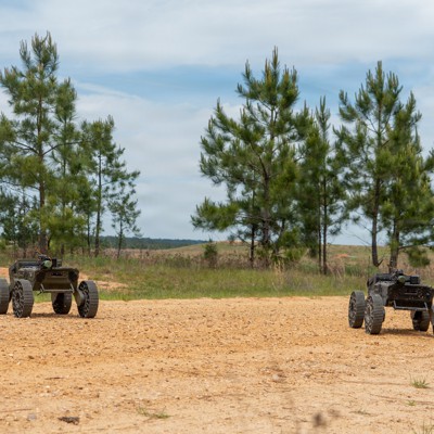
Swarmbotics AI FireAnt unmanned ground vehicles operate during a Joint Readiness Training Center rotation at Fort Polk, Louisiana, on April 20, 2026. U.S. Army / Spc. Sandy Vera Vazquez
Two startups are equipping small wheeled robots with a GPS-free nav package.
Two startups, working together for just under a week, may have found a way around the biggest obstacle to deploying swarms of ground robots: the need for GPS-free navigation in a small package.
Swarmbotics AI, which makes 100-pound autonomous robots, is teaming up with TERN, whose navigation software doesn’t need GPS, the companies announced Wednesday.
The Army has been seeking alternatives to the spoofable, jammable satellite-based system for years.
“The current environment has taught us that GPS is the first thing that gets canned on the battle space,” William Shuart, a program manager for the Army’s Pathfinder3D program, told Army magazine in January.
So the service is fielding jam-resistant GPS cards for munitions and is also working on ALTNAV , which uses a different satellite constellation. But its plans for a robot-forward ground force require a position-navigation-timing system that can get by without a satellite signal at all. The self-driving car industry, with its reliance on GPS and unstealthy LiDAR, hasn’t been much help.
Enter TERN, whose PNT system needs no signals from space, and Swarmbotics AI, an Arizona robotics company whose four-wheeled FireAnts fit roughly into a two-foot cube.
“Our teams integrated the TERN system on site here in Phoenix into the FireAnt in less than a week, which I think is really impressive. So we went from never having really spoken to these guys on a technical level at least to having the system fielded in a week,” said Drew Watson , co-founder and CTO of Swarmbotics AI .
TERN’s Independently Derived Positioning System, or IDPS, combines input from the vehicle’s own sensors, including “wheel speed, steering angle, and 3D motion data,” with onboard map data.
“We’re using the motion of that vehicle all the way down to something as as compact as a FireAnt, and through that successive motion, we're able to output latitude and longitude at the same rate that GPS could, or twice a second,” said Shaun Moore , co-founder and CEO of TERN .
Next up: sharing that information, which Watson described as “a building block to something else.” The team wants to move toward coordinated swarm maneuvering, with teams of robots sharing data with one another in a mesh network. If each member of the swarm understands where it is and where its teammates are, that data can add value to other sensor data, such as camera or radar feeds about threats.
“The way that's working is that each one of these FireAnts is giving a line of bearing to an enemy tank, for instance. Those are triangulated into a position of that enemy tank via multiple firings. The quality of that identification, the position of that enemy tank, is based on the position of the firings…It improves the automatic target recognition,” said Watson.
Both companies have already drawn Army attention. TERN received a $11.26 million contract in September, and both have participated in the service’s Operation Jailbreak tech demonstrations.
NEXT STORY: Army re-evaluating munitions procurement goals as Iran war continues
2026年4月20日,在路易斯安那州波尔克堡联合战备训练中心轮训期间,Swarmbotics公司的人工智能“火蚁”(FireAnt)无人地面车辆正在进行演习。美国陆军/下士桑迪·维拉·瓦兹奎兹
两家初创公司正在为小型轮式机器人配备无需 GPS 的导航系统。
两家初创公司合作不到一周,可能已经找到了克服部署地面机器人集群最大障碍的方法:即在小型设备中实现无需 GPS 的导航。
生产重达 100 磅的自主机器人的 Swarmbotics AI 公司周三宣布,将与 TERN 公司合作,TERN 的导航软件不需要 GPS。
多年来,陆军一直在寻找可欺骗、可干扰的卫星系统的替代方案。
“目前的形势告诉我们,GPS是战场上第一个被淘汰的东西,”陆军探路者3D项目的项目经理威廉·舒尔特在1月份接受《陆军》杂志采访时表示。
因此,该部门正在为弹药部署抗干扰GPS卡,同时也在研发使用不同卫星星座的ALTNAV系统。但其机器人前沿地面部队的计划需要一种完全无需卫星信号即可运行的位置导航授时系统。而依赖GPS和非隐蔽性激光雷达的自动驾驶汽车行业对此并没有太大帮助。
TERN 的 PNT 系统不需要来自太空的信号,而 Swarmbotics AI 是一家亚利桑那州的机器人公司,其四轮 FireAnt 机器人可以装进一个大约两英尺的立方体中。
Swarmbotics AI 的联合创始人兼首席技术官 Drew Watson 表示:“我们的团队在不到一周的时间内就将 TERN 系统集成到了位于凤凰城的 FireAnt 机器人上,我认为这非常令人印象深刻。我们之前从未真正与这些人进行过技术层面的交流,而现在,我们只用了一周时间就完成了系统的部署。”
TERN 的独立衍生定位系统 (IDPS) 将车辆自身传感器的输入(包括“车轮速度、转向角和 3D 运动数据”)与车载地图数据相结合。
TERN 的联合创始人兼首席执行官 Shaun Moore 表示:“我们利用车辆的运动,甚至小到像 FireAnt 这样紧凑的物体,通过这种连续的运动,我们能够以与 GPS 相同的速率(即每秒两次)输出纬度和经度。”
接下来是信息共享,沃森将其描述为“构建其他事物的基础”。团队希望实现协同集群机动,让机器人团队在网状网络中彼此共享数据。如果集群中的每个成员都能了解自身位置以及其他成员的位置,这些数据就能为其他传感器数据(例如摄像头或雷达获取的威胁信息)增添价值。
“其工作原理是,每个火蚁导弹都会给出敌方坦克的方位角。通过多次射击,这些方位角会被三角定位,从而确定敌方坦克的具体位置。识别敌方坦克位置的准确性取决于射击的位置……这提高了自动目标识别能力,”沃森说道。
这两家公司都已引起陆军的关注。TERN公司在9月份获得了一份价值1126万美元的合同,两家公司都参与了陆军的“越狱行动”(Operation Jailbreak)技术演示。
下一篇报道:随着伊朗战争持续,陆军重新评估弹药采购目标