How Drone Detection Is Evolving To Counter Smaller, Faster, And Swarm Threats无人机探测技术如何发展以应对更小、更快、更密集的威胁
Branded Content: Leonardo DRS explains how tactical radars form a central element of a layered counter-UAS threat detection system.
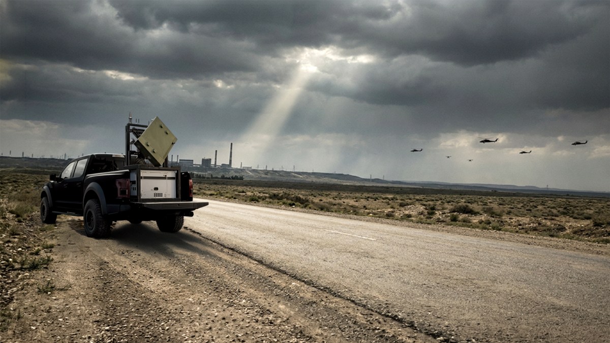
Published Sep 3, 2026 1:46 PM EDT
It’s the dead of night when the buzz of the engines of a series of Shahed-136 one-way attack drones breaks the silence. Carrying their lethal payloads the drones slip into the darkness with a distant supply base as their target. Tracking, identifying, and then destroying this swarm of drones is no easy task.
The unmanned aircraft system (UAS) threat environment is changing rapidly with an increasing variety of killer drones that demand differing methods of tracking and identification to engage and defeat them. Operational users are learning from rapidly-evolving- conflicts, and modern air defense methods increasingly rely on scalable, layered, and persistent sensing teams that can detect and track small, fast, low-altitude, and even swarming, aerial threats in all kinds of complex situations, on land or at sea.
A layered system is required to tackle the toughest drone threats. USAF
Ray Bischoff served active-duty with the U.S. Army for nearly 25 years, and he’s now the senior director of business development at Leonardo DRS , specialising in evaluating tactical formations and defensive requirements at all operational levels throughout the Department of War and allied nations. He is particularly focused on emerging threats from drones..
Bischoff spoke at length with TWZ’s Jamie Hunter about the use of tactical radar systems as part of a layered counter-drone system that is sufficiently versatile to tackle the toughest drone problems now, and what may come in the near future.
JH: Can you set the scene with regards to how you see the counter-UAS mission right now from a sensing perspective.
RB: The counter-UAS environment is changing and advancing very quickly. At the top level, we need to employ a variety of sensor systems – in this particular case we’re talking about tactical radars – but there are many other types of sensors, and at the highest end of the threat level it’s about connecting these together into a networked architecture.
Layering different systems in depth is vital, both from a communications architecture perspective and physically layering them in different places to protect different routes or avenues of approach, or sensitive facilities.
Look at the Strait of Hormuz, for instance, which is a vast area, with a layered and networked system to maximize the depth of coverage. The primary reason for this is that the biggest enemy in many situations like these is time. That networked architecture and having sensors in depth really gains you time, which gives you opportunities to make a better decision, time to reposition, to better evaluate. You need time to evaluate what different things in space are doing, where they’re going or where they’re coming from.
JH: When you say layered, are you talking about different systems that can look in different ways over different distances and systems in different positions that help you with that time element? What does layered actually mean?
RB: You can layer different types of sensors. Think of baseball. If all your players are home-run hitters, you probably aren’t going to do very well. You need to have different skills across your team to succeed, and it’s the same thing here. Layering of radar sensing bands, different types of technology such as electro-optic and infra-red that “see” in long, short and midwave, acoustic sensors, electronic warfare sensors to look for signals and other types of energy. It’s also about physically layering them in space, or depth.
Large drone swarms are particularly challenging to defend against. U.S. Army
We often see large exquisite sensors that have a lot of range and cover a large area. But this makes them susceptible to being targeted and destroyed. Layering sensors gives you redundancy, retaining the ability to defend. So, this is layering both in physical location, and in different types of technology.
This way, if one of your sensors is taken down by any means – for example by electronic countermeasures – your other systems can theoretically continue to operate. Just think how you can see, smell, touch, taste – it’s the same concept with layering different types of technologies, which is exactly what we at Leonardo DRS do and we integrate them so we can interact and share information to maximize the benefits of this layered approach. A team ultimately makes the sensors more effective across networks and architectures.
JH: Presumably you get good indicators on developments from the current operations in Ukraine . You already mentioned the Strait of Hormuz as well. What are the big lessons that you’re getting here about different types and sizes of drones?
RB: Without going into the details of combat operations, the bottom line is you have to advance your technologies at the rate or as close to the rate of the advancement of the weapons systems that are being utilized. We’re seeing a mixture of things when it comes to the UASs; that’s larger craft that are getting faster and can carry heavier payloads, or smaller ones with longer ranges that can move through areas almost undetected.
There’s been so much investment in UAS technology, and they are becoming cheaper and easier to manufacture. People can 3D-print these things in their houses now. So, looking at this from a sensing perspective, that layering is becoming increasingly important.
We are looking to do things to counter these developments, such as maybe elevate the sensors to “see” across the top of the trees or place a sensor down in a valley – so that adds layering in altitude or elevation to remove blind spots. Just like the military, if you’re setting-up a defensive position, you have to cover what we called “dead space” where you can’t see with eyes or sensors from ground level.
Leonardo DRS’ 202 Expeditionary Skid (U-KIT-0091) is based on the company’s Extended Multi-Mission Hemispheric Radar. Leonardo DRS
JH: Can we dig further into the role of tactical radars in counter-UAS, specifically Leonardo DRS’ 202 Expeditionary Skid, which I believe is based on your Extended Multi-Mission Hemispheric Radar [exMHR].
RB: Radars “see” things that are physically present in space and time, and that’s why they are such great tools in the counter-UAS kit bag of sensors. That said, some radars are affected by weather and other factors, some work better in particular environments.
The 202 Expeditionary Skid is a new system from Leonardo DRS that uses our long-range exMHR, which is a software-defined AESA [ Active Electronically Scanned Array ] pulse-Doppler radar. It operates in the S-Band and that’s a very reliable band for all weather conditions including strong performance in dust storms and rain. When you get into K, Ku, and X-bands, they typically have smaller beams and therefore greater accuracy, but they suffer in poor weather and can become extremely degraded. S-band radar suffers significantly less degradation in that environment.
The 202 Expeditionary Skid, also known as U-KIT-0091, has a single radar panel that has a search area of 90 degrees by 90 degrees, so we often mount them in groups of four to provide full 360-degree coverage. Each panel has a really fast scan rate, much faster than a traditional spinning radar set. Plus, having multiple radar faces to make up a complete system is much more survivable. They can also overlap their field of regard without impairing each other.
We have sought to provide a solution that marries an appropriate level of range, accuracy, capability, and performance, that can still be very flexible in its ability to relocate or change mission sets. This is designed to be extremely versatile, meaning that it operates in different environments quickly. U-KIT-0091 has been purposefully designed to be mobile in a compact system that can either be used by itself or networked and fused together with other systems. Back to the baseball analogy, this is the kind of guy you really want on your team because you can use them wherever you need them.
The radar or set of radars sit on a small skid system that can slide into the back of a pickup truck, into the back of a tactical vehicle, onto a trailer, you can set it just about anywhere and it occupies a four-by-four-feet position. It has its own power generation, its own positional information that works in denied environments, basically it’s capable of working by itself from the get-go. The best part is that it’s truly mobile – the operator doesn’t have to stop the vehicle to make it work. You can turn it on and set-off. It’s working. If you come to a stop, it’s still working. It can be mounted on a ship, it can be taken airborne by an aircraft, so it’s got land, sea, and air applications. We’ve installed these on all types of ground platforms, water-based platforms, on top of a building or some sort of structure and it’s already in service, but I can’t specify where. It tracks drones very well, but of course it can track just about anything that can exist in that space.
The 202 Expeditionary Skid U-KIT-0091 mounted in the back of a pickup truck. Leonardo DRS
JH: So you could strategically locate several of your radars to look in different directions or be positioned to look in a certain direction if you knew the expected paths that the threats would use?
RB: The system is designed exactly for things like that. Instead of putting all of your eggs in one basket, you disperse your eggs, and focus on different avenues or approach angles so that you can then have sensors strategically located where they can pick up these things and then as long as they’re networked back into weapons systems that have the overlapping fields of fire or bubbles – coverage areas – then you can protect your area.
Any time you can decouple a sensor from a weapon system or multiple types of sensors from each other, you stand a far greater chance of survivability and optimizing accuracy. If you put all your eggs in one basket, and if you lose that basket, you lose everything. In addition, if you separate sensors, you gain accuracy because you have different angles and you can leverage simple geometry.
JH: Could you depict what an end-to-end engagement might look like using your tactical radar.
RB: The radar sensors will typically be emitting energy as they search for objects in a particular space. If something is detected and determined to be a valid target then the data is sent from the radar to some type of a command and control system, which may well be receiving information from other complementary sensors too. It then fuses that data and passes it to an effector, whether that’s a non-kinetic or a kinetic system, for engagement.
Meanwhile, the radar continues to track and it can determine whether that object was removed or if its path changed, and so on and so forth. But you know, a lot of these radars operate in a way whereby they can be turned on or off by different sensors to avoid them having to constantly transmit energy, they’re very customizable to meet the requirements and the emissions that are needed, whether that’s air defense, counter-drone, etc.
They can operate independently too, maybe covering a small area that needs to be protected, and integrated with a localized weapon system, or, as I already explained, they can be networked into a much larger set-up, they are modular, open system architecture and easily incorporated.
Most customers tend to choose their own command and control systems, which is why the plug-and-play part of our system is so important. It really doesn’t matter what they want to partner it with, what we provide enables that very easily.
A counter-drone exercise run by the Joint Task Force-National Capital Region/United States Army Military District of Washington. U.S. Army/Sgt. Zack Stine
JH: To be clear, your tactical radars could be deployed to defend the entire eastern seaboard of the U.S., they could be positioned to defend an air base , or they could be used to defend a ship in the Strait of Hormuz.
RB: The architecture can scale geographically through a distributed, networked sensor approach . The specific coverage area depends on factors including sensor density, the threat environment, command-and-control integration, and the available effectors.
Customers can deploy multiple radars and feed them into a single command-and-control system, positioning sensors to optimize coverage for the operational need. For example, one radar set could cover a valley vulnerable to low-flying drone ingress, while another positioned on higher ground provides longer-range surveillance. The key is a modular capability that enables users to tailor coverage and layer sensors where they are most needed – without relying on one large radar system to see everything from a single location.
JH: I’m keen to know what you consider to be the most challenging drones to detect and track. Is the challenge the speed they’re traveling out at, maybe new low observable designs, or the fact they’re flying very low. What are the big issues you’re seeing?
RB: It’s really all of the above. The other really challenging problem is when something is flying very low to the ground. The lower they bring them in altitude, they are harder to track as an independent target.
The challenge with drone swarms isn’t detection – if you can see the drones, you can track them. The harder problem is managing those tracks, deciding which threats matter most, and assigning the right effector to each one.
If 100 drones are inbound, it’s not just about having 100 weapons available. It’s about coordinating a fast, cost-effective response across a large number of simultaneous threats.
Ultimately, pairing radars and electro-optical/infrared sensors together is the way to go, because each of those have their own strengths. One of those sensors is going to see the drone better than the other, plus you have the redundancy that at least a couple of them will “see” the threat and give you enough information in sufficient time to prosecute it. Fitting into that team, however it is constructed, is exactly how we position our 202 Expeditionary Skid U-KIT-0091 radar.
Contact the write: Jamie.Hunter@teamrecurrent.io
Comments couldn’t be loaded. Please refresh the page.
发布于美国东部时间2026年9月3日下午1:46
夜深人静之时,一连串“沙赫德-136”单向攻击无人机的引擎轰鸣声打破了寂静。这些无人机携带着致命的弹药,悄然潜入夜色,目标是远处的补给基地。追踪、识别并摧毁这群无人机绝非易事。
随着种类日益增多的攻击型无人机出现,无人机系统(UAS)的威胁环境正在迅速变化,需要采用不同的跟踪和识别方法来拦截和击败它们。作战用户正在从快速演变的冲突中吸取经验,现代防空方法越来越依赖于可扩展、分层且持续的感知团队,这些团队能够在各种复杂情况下(无论是在陆地还是海上)探测和跟踪小型、快速、低空甚至集群式的空中威胁。
应对最严峻的无人机威胁需要多层防御系统。——美国空军
雷·比肖夫曾在美国陆军服役近25年,现任莱昂纳多DRS公司业务发展高级总监,专门负责评估美国战争部及其盟国各作战层级的战术编队和防御需求。他尤其关注无人机带来的新兴威胁。
Bischoff 与 TWZ 的 Jamie Hunter 进行了长时间的交谈,讨论了战术雷达系统作为分层反无人机系统的一部分的应用,该系统具有足够的通用性,可以应对当前最棘手的无人机问题,以及在不久的将来可能出现的问题。
JH:您能否从感知角度描述一下您目前对反无人机系统任务的看法?
RB:反无人机系统环境变化迅速,发展日新月异。在最高层面上,我们需要运用多种传感器系统——就目前而言,我们指的是战术雷达——但还有许多其他类型的传感器,而在最高级别的威胁下,关键在于将这些传感器连接成一个网络架构。
从通信架构的角度来看,以及为了保护不同的路线或途径,或者为了保护敏感设施,在不同的地方进行物理分层,深度分层是至关重要的。
以霍尔木兹海峡为例,这是一个幅员辽阔的区域,拥有分层网络化的系统,以最大限度地扩大覆盖范围。这样做的主要原因是,在很多类似情况下,最大的敌人是时间。这种网络化架构和纵深部署的传感器确实能为你争取时间,让你有机会做出更明智的决策,重新部署,并进行更全面的评估。你需要时间来评估太空中不同目标的动向、它们的行进方向和来源。
JH:你说的“分层”是指在不同距离上呈现不同外观的不同系统,还是指处于不同位置、有助于你理解时间因素的系统?“分层”究竟是什么意思?
RB:你可以叠加不同类型的传感器。想想棒球。如果你的所有球员都是全垒打手,你可能不会取得好成绩。你的团队需要具备不同的技能才能成功,这里也是一样。叠加雷达传感频段,不同类型的技术,例如在长波、短波和中波“探测”的光电和红外传感器,声学传感器,用于探测信号和其他类型的能量的电子战传感器。这还涉及到在空间或深度上的物理叠加。
大规模无人机群的防御尤其困难。美国陆军
我们经常看到一些体积庞大、功能精良的传感器,它们探测范围广、覆盖面积大。但这使得它们很容易成为攻击目标并被摧毁。传感器分层部署可以提供冗余,从而保持防御能力。因此,这种分层部署既体现在物理位置上,也体现在不同类型的技术上。
这样一来,即使您的某个传感器因任何原因(例如电子对抗)而失效,理论上其他系统仍能继续运行。想想您是如何感知世界、嗅觉、触觉和味觉的——这与将不同类型的技术分层叠加的原理相同,而这正是 Leonardo DRS 所做的。我们将这些技术集成起来,以便进行交互和信息共享,从而最大限度地发挥这种分层方法的优势。最终,团队协作能够使传感器在各种网络和架构中更高效地工作。
JH:想必您能从目前在乌克兰的行动中获得一些关于局势发展的良好指标。您刚才也提到了霍尔木兹海峡。您从中获得了哪些关于不同类型和尺寸无人机的重要经验教训?
RB:暂且不谈作战行动的细节,关键在于你的技术发展速度必须与武器系统的发展速度保持一致,或者尽可能接近。就无人机系统而言,我们看到两种发展趋势:既有体积更大、速度更快、有效载荷更重的机型,也有体积更小、航程更远、几乎可以隐蔽飞行的机型。
无人机系统(UAS)技术获得了大量投资,其制造成本也越来越低,制造工艺也越来越简便。现在人们甚至可以在家3D打印这些设备。因此,从传感的角度来看,这种分层结构变得越来越重要。
我们正在寻求应对这些发展趋势的方法,例如将传感器架高,使其能够越过树梢进行“探测”,或者将传感器放置在山谷中——这样可以增加高度层次,消除盲区。就像军队一样,如果你要建立防御阵地,就必须覆盖我们所说的“盲区”,也就是从地面上肉眼或传感器无法看到的区域。
Leonardo DRS 的 202 型远征滑橇(U-KIT-0091)基于该公司开发的扩展型多任务半球雷达。
JH:我们能否进一步探讨战术雷达在反无人机系统中的作用,特别是 Leonardo DRS 的 202 远征滑橇式雷达,我相信它是基于你们的扩展多任务半球雷达 [exMHR] 开发的。
RB:雷达能够“看到”在空间和时间中实际存在的物体,因此它们是反无人机系统传感器工具包中非常强大的工具。话虽如此,有些雷达会受到天气和其他因素的影响,有些雷达在特定环境下性能更佳。
202 远征滑橇系统是 Leonardo DRS 公司推出的全新系统,它采用我们远程 exMHR 雷达,这是一款软件定义的 AESA(有源电子扫描阵列)脉冲多普勒雷达。该雷达工作在 S 波段,这是一个非常可靠的波段,适用于各种天气条件,即使在沙尘暴和暴雨中也能保持良好的性能。K、Ku 和 X 波段的雷达通常具有更小的波束,因此精度更高,但在恶劣天气下性能会大幅下降。相比之下,S 波段雷达在恶劣环境下的性能下降要小得多。
202型远征滑橇式雷达(也称U-KIT-0091)配备一个雷达面板,其搜索范围为90度×90度。因此,我们通常将它们四个一组安装,以实现360度全方位覆盖。每个面板的扫描速度都非常快,远超传统的旋转雷达。此外,由多个雷达面板组成的完整系统也大大提高了生存能力。而且,它们可以重叠各自的探测范围而不会相互干扰。
我们力求提供一种解决方案,它能够兼顾合适的探测范围、精度、能力和性能,同时还能灵活地进行任务部署或变更。该方案设计极其通用,这意味着它能够快速适应不同的环境。U-KIT-0091 的设计初衷是使其能够在紧凑的系统中实现移动,既可以独立使用,也可以与其他系统联网融合。用棒球来打比方,U-KIT-0091 就像你梦寐以求的队友,因为无论何时何地,你都可以随时使用它。
这套雷达系统安装在一个小型滑橇上,可以滑入皮卡车的后部、战术车辆的后部或拖车上,几乎可以安装在任何地方,占地面积仅为四英尺乘四英尺。它拥有独立的电源和定位信息系统,即使在信号受限的环境中也能正常工作,基本上从一开始就能独立运行。最棒的是它的机动性——操作员无需停车即可操作。只需打开电源即可启动,即使车辆停止,它也能继续工作。它可以安装在舰船上,也可以由飞机携带上空,因此适用于陆地、海洋和空中。我们已经在各种地面平台、水上平台、建筑物或其他结构上安装了这套系统,并且已经投入使用,但我不能透露具体位置。它对无人机的追踪效果非常好,当然,它几乎可以追踪该空间中可能存在的任何东西。
202 Expeditionary Skid U-KIT-0091 安装在皮卡车的后部。Leonardo DRS
JH:所以,如果你知道威胁可能使用的路径,就可以策略性地部署多个雷达,让它们朝向不同的方向,或者让它们朝向某个特定方向进行监视?
RB:这套系统正是为此类情况而设计的。与其把所有鸡蛋放在一个篮子里,不如分散鸡蛋,集中精力于不同的途径或角度,这样就可以在战略位置部署传感器,使其能够捕捉到这些目标。只要这些传感器与武器系统联网,而武器系统的火力范围或覆盖区域相互重叠,那么就可以保护你的区域。
任何时候,只要能将传感器从武器系统中分离出来,或者将多种类型的传感器彼此分离,就能大大提高生存几率并优化精度。如果把所有鸡蛋都放在一个篮子里,一旦这个篮子丢了,就什么都失去了。此外,分离传感器还能提高精度,因为可以从不同的角度进行测量,并利用简单的几何原理。
JH:您能否利用您的战术雷达描述一下端到端交战的情况?
RB:雷达传感器通常会在特定空间内搜索目标时发射能量。如果探测到目标并确认其有效,数据将从雷达发送到某种指挥控制系统,该系统可能还会接收来自其他辅助传感器的信息。然后,系统将这些数据融合,并将其传递给执行器(无论是动能系统还是非动能系统)进行攻击。
与此同时,雷达持续追踪目标,可以判断目标是否被移除或路径是否改变等等。你知道,很多这类雷达的运行方式都允许不同的传感器控制它们的开关,从而避免持续发射能量。它们具有很高的可定制性,能够满足各种应用需求和辐射模式,例如防空、反无人机等等。
它们也可以独立运行,或许可以覆盖需要保护的小区域,并与本地武器系统集成;或者,正如我已经解释过的,它们可以联网组成更大的系统,它们是模块化的、开放的系统架构,易于集成。
大多数客户倾向于自行选择指挥控制系统,因此我们系统的即插即用特性至关重要。无论他们想与什么系统配合使用,我们提供的解决方案都能轻松实现。
由美国陆军首都地区联合特遣部队/华盛顿军区联合开展的反无人机演习。美国陆军/中士扎克·斯泰恩
JH:说清楚点,你们的战术雷达可以部署用于保卫美国整个东海岸,可以部署用于保卫空军基地,也可以用于保卫霍尔木兹海峡中的船只。
RB:该架构可通过分布式网络传感器方法实现地理扩展。具体覆盖范围取决于多种因素,包括传感器密度、威胁环境、指挥控制集成以及可用执行器。
客户可以部署多部雷达,并将数据整合到单一的指挥控制系统中,通过调整传感器位置来优化覆盖范围,以满足作战需求。例如,一套雷达可以覆盖易受低空无人机入侵的山谷,而另一套雷达则可以部署在地势较高的地方,提供更远距离的监视。关键在于其模块化设计,使用户能够根据实际需要定制覆盖范围并分层部署传感器,而无需依赖单一的大型雷达系统从单一位置获取所有信息。
JH:我很想知道您认为最难探测和追踪的无人机是什么。是它们的飞行速度,还是新型的低可探测性设计,又或者是它们超低空飞行?您遇到的主要问题是什么?
RB:确实以上所有情况都有涉及。另一个极具挑战性的问题是当目标飞行高度非常低时。飞行高度越低,就越难将其作为独立目标进行追踪。
无人机群的挑战不在于探测——只要能看到无人机,就能追踪它们。更难的是如何管理这些追踪目标,判断哪些威胁最为重要,并为每项威胁分配合适的攻击手段。
如果有100架无人机来袭,关键不在于是否拥有100件武器,而在于如何协调应对大量同时发生的威胁,做出快速、经济高效的反应。
最终,将雷达和光电/红外传感器结合使用才是最佳方案,因为它们各有优势。其中一个传感器会比其他传感器更能有效地探测到无人机,而且至少有两个传感器能够“发现”威胁,并在足够的时间内提供足够的信息来采取应对措施,从而实现冗余。无论团队如何构建,我们的202远征滑橇式U-KIT-0091雷达正是以融入其中为目标而设计的。
联系作者:Jamie.Hunter@teamrecurrent.io
评论加载失败,请刷新页面。