Nepal’s deadly Himalayan tsunami: Climate change, glacier retreat or natural geology — what caused it?尼泊尔致命的喜马拉雅海啸:气候变化、冰川消退还是自然地质——究竟是什么原因造成的?
KATHMANDU, Sept 4 — Nepal is reeling from a deadly Himalayan glacial mountain collapse on the border with China that has killed more than 1,300 people and left upwards of 5,600...
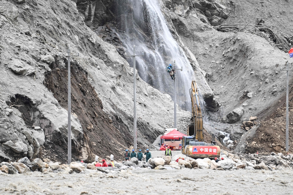
Nepal experienced a catastrophic Himalayan glacial mountain collapse on August 26, leading to over 1,300 fatalities and 5,600 people missing along the Nepal-China border.
The event, referred to as a "Himalayan tsunami," involved a large mass of ice and rock plunging from Langtang Lirung mountain and generating a rapid, destructive flow.
While climate change might have exacerbated conditions, experts caution against attributing the disaster solely to it, highlighting natural geological processes.
The incident underscores the urgent need for enhanced monitoring and predictive tools to avert future tragedies.
KATHMANDU, Sept 4 — Nepal is reeling from a deadly Himalayan glacial mountain collapse on the border with China that has killed more than 1,300 people and left upwards of 5,600 missing in both countries.
Scientists have been examining the August 26 catastrophe, dubbed a “Himalayan tsunami” by Nepal’s foreign minister.
Here is what experts — including from the Kathmandu-based International Centre for Integrated Mountain Development (ICIMOD) and the HiRISK group, focusing on Asia’s mountains — have deciphered so far.
On August 26 at 8.37am (0252 GMT), a mass of ice and rock broke away from the north face of Nepal’s Langtang Lirung mountain, sending a huge mass of debris racing down the valley.
The collapse began at an altitude of about 5,200 metres (17,060 feet) with a section more than a kilometre (0.6 miles) wide and extending roughly 700 metres vertically, according to ICIMOD.
That mass of rock and ice plunged about 800 metres onto a debris-covered glacier, before surging downhill, briefly damming the Lhende River. Water and debris then burst downstream.
The debris travelled about 20 kilometres, dropping 1,700 metres at Rasuwagadhi in only seven minutes, ICIMOD geologist Sudan Bikash Maharjan told AFP.
“The elevation difference is high, within a very short length,” Maharjan said. “So it just rushed down like a bullet train.”
The collapse swept up vast quantities of loose material as it descended, helping create an exceptionally destructive and fast-moving flow.
Experts are still investigating the large volume of water that allowed the debris to travel far downstream.
It also created two lakes. One has slowly drained. Experts believe the second one will not cause a high-magnitude flood.
Why did the mountain collapse?
Experts say several factors may have contributed, but it is too early to identify a single trigger.
The glacier in the area retreated by about 450 metres between 1990 and 2020, exposing rock that had previously been covered by ice.
Changes in temperature, moisture and permafrost may have weakened fractures in the exposed rock, while water entering cracks could have helped destabilise the slope.
But there was no earthquake, exceptional rainfall or sudden period of extreme heat immediately before the collapse, experts said.
“To pinpoint ‘this is the cause’, we need to go to the field, do the analysis,” Maharjan said.
A major earthquake in 2015 may also have contributed to longer-term instability. But experts are examining whether cracks may have developed in the mountain over a longer period.
Was role does climate change play?
Climate change may have contributed to conditions that made the slope more vulnerable, but experts caution against attributing the disaster solely to rising temperatures.
Warming has accelerated glacier retreat across the Himalayas, exposing previously ice-covered rock to changing temperatures and water conditions.
Permafrost degradation may also weaken mountain slopes and allow water to penetrate deeper into fractures.
“Climate change makes all this more likely,” geoscientist Jakob Steiner said, while noting that mountain collapses are also part of natural geological processes.
Could it have been predicted?
Scientists are examining possible warning signs, including evidence that the glacier accelerated in the weeks before the collapse, and a sudden increase in meltwater shortly beforehand.
But neither was enough to predict with certainty that a catastrophic collapse was imminent.
Steiner said the analysis should not suggest that authorities in Nepal or China would have known the mountain was about to fail.
“There are so many mountains in the region,” he said.
What may help prevent similar disasters?
Experts hope that understanding the events of August 26 will lead to the development of tools capable of predicting a recurrence.
“We are using... this knowledge now to be better prepared in future—to find tools that let us focus in on that ‘one needle in the haystack’, that we actually need to pay attention to,” Steiner told AFP.
Experts say better long-term monitoring, data sharing and coordination are crucial.
“We really need a dedicated mechanism... which works around the clock,” disaster specialist Saswata Sanyal told AFP. — AFP
As smoke spreads across South-east Asia, Indonesia works with neighbours to tackle transboundary haze
Japan warns of landslides on Yakushima off Kagoshima coast as Typhoon Krovanh brings heavy rain
US judge declares mistrial after jury deadlocks in Lindsay Clancy murder case
Police detain four in separate cable theft cases in Kampar and Kuala Kangsar
Serian haze eases slightly, but API remains hazardous at 390 at 7am; Kuching, Tebedu, Lundu remain at very unhealthy levels
Police detain 11 over machete attack in Ipoh that left victim seriously injured
8月26日,尼泊尔喜马拉雅山脉发生灾难性冰川崩塌,导致尼泊尔-中国边境沿线1300多人死亡,5600多人失踪。
这次事件被称为“喜马拉雅海啸”,涉及大量冰岩从朗唐里隆山崩塌,形成快速而破坏性的巨大气流。
虽然气候变化可能加剧了这种情况,但专家告诫不要将这场灾难完全归咎于气候变化,并强调了自然地质过程的重要性。
该事件凸显了加强监测和预测工具以避免未来悲剧发生的迫切需要。
加德满都,9 月 4 日——尼泊尔正遭受喜马拉雅山脉冰川崩塌的重创,这场灾难发生在尼泊尔与中国的边境,已造成两国 1300 多人死亡,5600 多人失踪。
科学家们一直在调查8月26日发生的灾难,尼泊尔外交部长将其称为“喜马拉雅海啸”。
以下是包括总部位于加德满都的国际山地综合发展中心 (ICIMOD) 和专注于亚洲山区的 HiRISK 小组在内的专家们迄今为止所解读的内容。
8 月 26 日上午 8 点 37 分(格林尼治标准时间 02:52),尼泊尔朗唐里隆山北坡崩塌,大量的冰岩崩落,裹挟着大量碎石顺着山谷滚落。
据 ICIMOD 称,坍塌始于海拔约 5200 米(17060 英尺)处,坍塌段宽超过 1 公里(0.6 英里),垂直延伸约 700 米。
那团岩石和冰块从约800米高处坠落到覆盖着碎石的冰川上,然后顺着山坡奔涌而下,短暂地阻塞了伦德河。随后,河水和碎石向下游奔涌而下。
ICIMOD 地质学家苏丹·比卡什·马哈尔詹告诉法新社,碎片飞行了约 20 公里,在短短七分钟内从拉苏瓦加迪落下 1700 米。
“海拔落差很大,而且距离很短,”马哈尔詹说。“所以它就像子弹头列车一样飞速冲下来。”
崩塌过程中裹挟了大量的松散物质向下流动,形成了破坏力极强、移动速度极快的泥石流。
专家们仍在调查为何如此大的水量能够让碎片向下游漂流很远。
它还形成了两个湖泊。其中一个湖泊的水位已经缓慢下降。专家认为第二个湖泊不会引发大规模洪水。
山体为何崩塌?
专家表示,可能有多种因素导致这一事件发生,但现在确定单一诱因还为时过早。
1990 年至 2020 年间,该地区的冰川后退了约 450 米,露出了之前被冰覆盖的岩石。
温度、湿度和永久冻土的变化可能会削弱裸露岩石中的裂缝,而水进入裂缝可能会导致斜坡不稳定。
专家表示,坍塌发生前并没有发生地震、异常降雨或突发极端高温天气。
“要找出‘这就是原因’,我们需要到现场进行分析,”马哈尔詹说。
2015年的一次大地震也可能加剧了山体的长期不稳定性。但专家们正在研究山体裂缝是否是长期积累的结果。
气候变化扮演了什么角色?
气候变化可能加剧了斜坡的脆弱性,但专家告诫不要将这场灾难完全归咎于气温上升。
全球变暖加速了喜马拉雅山脉冰川的退缩,使原本被冰雪覆盖的岩石暴露在不断变化的气温和水文条件下。
永久冻土退化也可能削弱山坡,使水能够更深入地渗入裂缝中。
“气候变化使这一切更有可能发生,”地球科学家雅各布·施泰纳说,同时指出山体崩塌也是自然地质过程的一部分。
这是否可以预测?
科学家们正在研究可能的预警信号,包括冰川在崩塌前几周加速运动的证据,以及崩塌前不久融水量的突然增加。
但这两点都不足以确切地预测灾难性的崩溃即将发生。
施泰纳表示,该分析不应暗示尼泊尔或中国的当局会知道这座山即将崩塌。
“这个地区有很多山,”他说。
哪些措施有助于预防类似灾难?
专家们希望,通过了解 8 月 26 日发生的事件,能够开发出预测此类事件再次发生的工具。
施泰纳告诉法新社:“我们现在正在利用这些知识,以便更好地为未来做好准备——找到能够让我们专注于‘大海捞针’的工具,也就是我们真正需要关注的事情。”
专家表示,加强长期监测、数据共享和协调至关重要。
“我们确实需要一个专门的机制……能够全天候运转,”灾害专家萨斯瓦塔·桑亚尔告诉法新社。——法新社
随着烟雾蔓延至东南亚,印尼与邻国合作应对跨境烟霾。
台风“克罗万”带来强降雨,日本警告鹿儿岛沿岸屋久岛可能发生山体滑坡
美国法官宣布林赛·克兰西谋杀案审判无效,此前陪审团未能达成一致意见。
警方在金宝和瓜拉江沙两地分别拘留了四名涉嫌盗窃电缆的嫌疑人。
西连雾霾略有缓解,但 API 仍处于危险状态,早上 7 点为 390;古晋、打必杜、伦杜仍然处于非常不健康的水平
怡保警方拘留11名涉嫌持刀袭击者,该袭击导致受害者重伤。受害者受伤。受害者受伤。怡保警方逮捕11名嫌疑人。