SR-71’s “R2-D2” Could Be The Key To Winning Future Fights In GPS Denied EnvironmentsSR-71的“R2-D2”可能是未来在GPS信号受限环境下赢得空战的关键
Our ancestors did it and so did the SR-71 Blackbird, now this ancient form of navigation could be set for a major comeback.
新闻视频
Updated Apr 16, 2019 4:31 PM EDT
With all the technology at our fingertips today, the very idea of celestial navigation remains a romantic and even a bit bewildering one. It harkens back to a time when mankind had a much richer connection with the heavens above. But the truth is the task of navigating by the stars became increasingly automated and miniaturized as a necessity of the Cold War. The advent of the Global Position System (GPS) and the diminished threat of all-out nuclear armageddon left advanced celestial navigation capabilities for a small number of weapon systems and the history books. But now, with the possibility of having to fight in a combat environment where GPS and all its benefits are denied, updated automated “astro-nav” capabilities may represent one of the best and most proven ways of overcoming this challenge.
Suffice to say that beginning in Operation Desert Storm , America’s military might has become increasingly dependent on a stable and highly accurate GPS system. Everything from ballistic missile submarines to formations of armor use this service to leverage instant geo-locating abilities, as do the majority of guided munitions, and especially those that are fired from standoff ranges.
Combat aircraft and fighting ships largely navigate using inertial navigation systems (INS) with embedded GPS. You can read all about these amazing pieces of technology here . Inertial navigation systems have gyros that are capable of sensing inertia and orientation and work as something of a self-contained dead-reckoning apparatus. They alone are capable of getting an aircraft or ship into the general area it needs to be, but over space and time their positioning accuracy degrades. In other words, the longer a vehicle navigates on INS alone, the more inaccurate their actual position will be.
A modern miniaturized ring-laser gyro system., Honeywell
These systems are especially susceptible to drift if they don’t get periodic “updates” from another navigational source, such as GPS or radio navigation aids. INS with embedded GPS systems aren’t just found on large military vehicles either, they are also used on munitions as lowly as the Joint Direct Attack Munition (JDAM) and even guided artillery shells.
INS with embedded GPS works as sort of a voting set of systems that use software algorithms or filters to collectively best decide upon the aircraft’s position based on the data at hand. If one source begins to stray heavily or shows signs of malfunction, software can discount it and rely more heavily on the other. GPS spoofing, where the GPS signal is replaced with a fake one, is one electronic warfare tactic that is becoming alarming common, with Russia using it during training and other mysterious scenarios in the recent past.
Advanced and highly targeted GPS spoofing attacks could theoretically be especially insidious as the fake signal could provide data that slowly changes a vehicle’s true location over time, making the anomaly far less noticeable to human operators or to a GPS/INS navigation systems of software logic.
These more localized and targeted GPS tampering tactics are one thing, but denying GPS over a small or broad area altogether is even more concerning, and this is a threat that is growing in size and complexity, with Russia indicating they would leverage it to gain an asymmetric advantage during a time of war.
Electronic and cyber warfare are the likely avenues of such an attack, but anti-satellite weaponry that can disable, jam, or even destroy satellite navigation capabilities at the source are a more troubling tactical possibility to factor in when facing off against a capable peer-state foe. But lower-end jamming and cyber attack capabilities targeting GPS aren’t just relegated to traditional foes. Non-state actors will be increasingly capable of waging war on this level as well.
With all this in mind, GPS vulnerability has become a far more pressing strategic issue as of late and the Pentagon is scrambling to find new ways—or even old ways—of negating the impact of these types of enemy operations. One potential antidote for the issue, at least for some systems and platforms, may include reviving and modernizing a truly “back to the future” concept—automated celestial navigation, also referred to as “astro-nav.”
From sextants to R2-D2
Decades before the advent of GPS, manual celestial navigation remained a skill used in both the maritime environment and in the skies. Even fairly modern aircraft were designed with this form of navigation in mind. For instance, the 747 was designed with a sextant port, and the VC-10 and 737 were designed with a sextant periscope. But even this secondary navigation aid became obsolete as radio navigational systems became far more prevalent and accurate.
A VC-10 navigator “takes a shot” using the aircraft’s periscope sextant. , BOAC image via VC10.net
Like so many key technologies we enjoy today, automated astro-navigation was introduced as a necessity of the Cold War. With the advent of weapons capable of traveling vast distances at high speed, there had to be a way to automatically correct for the inaccuracies that were intrinsic to inertial navigation systems. This problem gave birth to the astro-inertial navigation system (ANS).
An absolutely cutting-edge system at the time of its conception, it was capable of automatically cross-checking a vehicle’s position as defined by its INS with that defined by its relation to the stars. This drastically improved the overall system’s accuracy and was able to correct for drift-related errors intrinsic to INS. This capability was first introduced on the SM-62 Snark cruise missile. The Snark was America’s precursor to the age of nuclear-tipped ballistic missiles.
Initially, in 1957, the Snark showed that it had a circular error probability, also known as CEP (where the missile would impact in relation to its target), of 17 miles after flying thousands of miles downrange at high subsonic speeds to its target area. Even for a high-yield nuclear delivery system this was unacceptable. By 1958 the ANS system was installed and its CPE shrunk to four miles—an amazing accomplishment considering the technology of the era.
The Snark’s astro-nav system. , Smithsonian Air and Space Museum
The concept was drastically refined over the following years and AIN units found themselves on high-end platforms, including virtually all U.S. ICBMs to this very day, and one of the most incredible engineering accomplishments of all time—the SR-71 Blackbird .
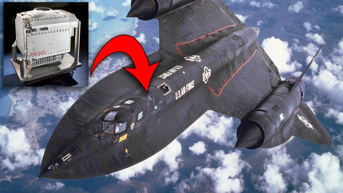
Because of the SR-71’s speed, proximity to very hostile countries, and the need to automate its reconnaissance sensors, not to mention the nature of its critical mission set, having highly accurate navigation that didn’t tax the crew’s resources unnecessarily was absolutely essential. The Nortronics NAS-14V2 astro-inertial navigation system provided this functionality for the Skunk Works’ mach three spy plane.
The crate-sized guidance group, with the ANS on top, was dropped into the jet’s spine before missions. This system was eventually known by Blackbird crews, mission planners, and maintainers as “R2-D2,” and its job wasn’t that far from that of its famed Star Wars astromech droid namesake.
NAS-14V2 , Smithsonian
In a previous post featuring an incredible hands-on video tour of the Blackbird’s cockpits, SR-71 pilot Richard Graham also describes the jet’s astro-inertial navigation system in detail along with other recollections about operating the famous jet. The video is reposted below and the relevant part about the jet’s guidance group begins just at 53 minutes. It is an absolute must watch :
Graham describes how all of the Blackbird’s sensors and navigation systems are automated by the guidance group, and the entire mission is pre-programmed into this system and the mission is tested on the ground before flight. The astro-nav’s gimbaled telescope-like system on top of the guidance group works by making an ever-widening circular search pattern to find and fix three of any of 64 mapped stars in its memory, and compares their locations to a Julian calendar and a highly accurate chronometer. And from this it provides a precise position as the jet sits on the ground or as it hurtles through the air at 80,000 feet and mach three. And all of the SR-71’s sensors are automatically programmed to take images, both optical and radar, based on where the aircraft is in time and space during its mission as defined by the astro-nav.
Graham goes on to make the point that really, the system isn’t that different than GPS that we use today. Instead of using a constellation of chronometer-packing satellites in orbit around the earth, the astro-nav uses the light from distant stars and its own chronometer to figure out its location.
The gimbaled “telescope” on the NAS-14-V2, Smithsonian
Evolved variations of the NAS-14V2 found themselves on other strategic aircraft as well, most notably the B-2 Spirit stealth bomber. The system is flush mounted to the left of the cockpit near the B-2’s intake. You can clearly see the plate-sized quartz glass window that covers the astro-tracker’s gimbaled telescope in aerial refueling photos like the one below. Other astro-nav systems, like Lockheed’s AST-201, are also used on satellites so that they can independently orient themselves.
You can see the astro-tracking system under the round window to the right of the B-2’s cockpit in this image. , USAF
Another more advanced system was designed for the B-1B , called the ANS-26, which had a different configuration than that of the NAS-14, but even during the waning days of SR-71 Blackbird operations, the system combined with INS was supposedly able to put the aircraft within roughly a 300 foot box in space and time.
Bringing automatic celestial navigation into the future
New astro-trackers use a far less mechanically complex systems to provide astro-tracking, such as those that get rid of the gimbaled telescope and use a very wide angle staring sensor array in its place. This technology has actually been around since the end of the Cold War in the form of systems like Northrop’s Optical Wide-angle Lens Startracker (OWLS), which uses a holographic lens and a sensor system that is far more sensitive and thus more capable of detecting stars.
More recently Northrop Grumman has fielded its LN-120G Stellar-Inertial-GPS navigation system that is used on RC-135 surveillance aircraft. This relatively compact system integrates a modern INS system with GPS and astro-tracking, giving a triple redundant capability and positive performance even in GPS-spoofing or GPS-denied environments. Considering where these aircraft operate—near the borders of potentially hostile countries—it is a very good capability to have.
Today, this type of capability could be miniaturized even further, possibly into a shoebox-sized array and computing system, one that uses multiple staring CCD arrays to continuously scan the entire sky at one time. Such a system could be flush mounted into combat aircraft or possibly carried in a pod that protrudes from under a tactical aircraft’s wing.
Even something like the F-35’s Distributed Aperture System (DAS) may be capable, or at least adaptable, to providing highly precise celestial navigation running as something of a “background app” on top of the system’s other tactical functions. And instead of having 64 stars in its memory banks it could have thousands, and may be able to drastically reduce the margin of inaccuracy of earlier systems.
F-35B during a night test sortie, USMC
Regardless of the exact configuration of a modern airborne celestial navigation system, such a capability could largely overcome the loss of GPS. It may even be possible to create a “virtual GPS” system by using high-flying aircraft with astro-navigation and other GPS denied technologies installed onboard to support tactical platforms operating below. Such a concept could allow for a semi-centralized GPS replacement approach and would theoretically be able to not just provide navigation for aircraft but also for their weaponry, at least over a finite period of time and geographic area. In other words, only these high-flying aircraft would require unique systems like astro-nav, but all the allied aircraft and weaponry in their immediate combat environment would benefit from them in a similar fashion to how GPS functions today.
For instance, a trio of high-altitude, long-endurance (HALE) stealthy drones , such as the shadowy RQ-180, or even high-flying B-21 bombers , could penetrate into enemy airspace prior to or along with a strike force of tactical aircraft, cruise missiles, and air-launched decoys . These HALE platforms would use automatic celestial navigation systems and well as other advanced GPS denied navigation tactics, to establish a very accurate position at all times and then they could data-link this information to the tactical platforms and munitions below.
This would allow these assets to come up with highly precise positioning in time and space. Basically, this is a temporary and survivable GPS network. And because it isn’t persistent, it would be much harder to degrade or outright jam. If it could use proprietary data-links , especially the directional kind such as the F-35’s MADL , instead of an omni-directional GPS-like or Link 16 signal, it could be even more survivable.
For the future, unmanned combat air vehicle swarms could leverage celestial navigation and would also be able to do so in a cheaper “distributed” manner. Not all UCAVs in a swarm would need such a system, say just one per division, or sub-swarm, of say between six and a dozen aircraft. That aircraft can provide positioning updates to other UCAVs in their division. If that UCAV were lost or had a mission abort, that division could simply joint another with a functioning astro-nav carrying unit. Benefits and increased accuracy could also likely be realized by networking multiple astro-nav equipped drones together over a large area.
Pairing this capability with other capabilities, like miniaturized atomic clocks and/or BAE’s Navigation Via Signals of Opportunity (NAVSOP), which uses existing electromagnetic radiation in the environment, like cell phone tower and television signals, or even the emissions from GPS jammers themselves, to provide positioning information, or onboard atomic clocks, or radar imagery matching concepts, could result in highly reliable and redundant automated navigational capabilities without the need for space-based assistance.
The bottom line here is that we know by experience that celestial navigation, the oldest form of navigation really, works very well in an automated form, and considering how far technology has come since the end of the Cold War, especially in terms of automation and sensors, the astro-nav concept is likely ready for a massive breakthrough in miniaturization and accuracy. In doing so, it could give the U.S. a decisive edge in future high-end combat scenarios, and some of those scenarios may include U.S. forces jamming GPS around themselves on their own accord.
Years ago I predicted that small hobbyist-like drones would become the scourge of the modern battlefield as well as the terrorist assassins of the future. Sadly, reality has arrived, and a future where swarms of small drones will be a mainstream military capability for which there is little established kinetic defense against is now on the horizon. But the Achilles heal of this concept is that small and cheap drones rely entirely on GPS navigation . So denying GPS around friendly troop emplacements, vessels, airstrips, and other critical infrastructure could be the only realistic defense against it. In other words, having the ability to “turn off” GPS by whatever means without it having a major impact on your own military operations could be a massive strategic advantage in future conflicts.
Time for an astro-navigation 2.0
An astro-navigation renaissance is already underway in the U.S. Navy, which is teaching ancient skills to its sailors once again due to the threat of losing GPS capabilities. And there are increasing calls to field new automated astro-nav systems on vessels to augment, and in the case of war, even take the place of GPS in their integrated navigational suites. Don’t be surprised if this technology begins to be assessed by the Army for land combat uses as well.
Of course there are limitations to these systems as well, and poor weather and battlefield obscurants can drastically curtail their use. But these issues are far less impactful on aircraft, and especially high-flying ones that serve strategic purposes.
In the end reviving this Cold War era concept seems like one of the easiest ways of providing a more resilient combat force capable of taking on future enemy tactics. When these systems are paired with other emerging anti-GPS denial technologies they could provide a potent alternative to GPS to the point that maybe American warfighters would be able to do without the service in order to gain a leg-up on the enemy who doesn’t benefit from such a capability.
Above all else the asto-nav is another reminder that some of the hardest problems facing military planners today could very well be answered using technologies once deemed obsolete. When it comes to celestial navigation, looking “back to the future” may be far easier a proposition that simply looking forward.
Contact the author: Tyler@thedrive.com
Comments couldn’t be loaded. Please refresh the page.
更新于美国东部时间2019年4月16日下午4:31
如今科技如此发达,天文导航的概念依然充满浪漫色彩,甚至令人有些费解。它让人回想起人类与苍穹联系更为紧密的时代。但事实上,由于冷战的需要,星象导航变得越来越自动化和小型化。全球定位系统(GPS)的出现以及全面核战争威胁的减弱,使得先进的天文导航技术仅限于少数武器系统,最终只能载入史册。然而,如今,我们可能不得不面对GPS及其所有优势无法使用的作战环境,因此,升级后的自动化“天文导航”技术或许是应对这一挑战的最佳且最有效的方法之一。
毋庸置疑,自“沙漠风暴”行动以来,美国的军事力量越来越依赖于稳定且高精度的全球定位系统(GPS)。从弹道导弹潜艇到装甲部队,所有军事装备都利用这项服务进行即时定位,大多数制导武器,特别是那些从防区外发射的制导武器,也同样如此。
作战飞机和舰艇主要依靠内置GPS的惯性导航系统(INS)进行导航。您可以在这里了解这些令人惊叹的技术。惯性导航系统配备陀螺仪,能够感知惯性和方向,并可作为独立的航位推算装置。它能够将飞机或舰艇引导到大致目标区域,但随着时间的推移和空间的推算,其定位精度会逐渐降低。换句话说,飞行器仅依靠惯性导航系统导航的时间越长,其实际位置的误差就越大。
霍尼韦尔公司出品的现代小型化环形激光陀螺仪系统
如果这些系统不能定期从其他导航源(例如 GPS 或无线电导航设备)获取“更新”,它们就特别容易发生漂移。内置 GPS 系统的惯性导航系统不仅应用于大型军用车辆,也应用于联合直接攻击弹药 (JDAM) 等小型弹药,甚至制导炮弹。
内置GPS的惯性导航系统(INS)的工作原理类似于一个投票系统,它利用软件算法或滤波器,根据现有数据共同确定飞机的最佳位置。如果某个数据源出现严重偏差或故障迹象,软件可以忽略该数据源,更多地依赖其他数据源。GPS欺骗,即用虚假信号替换真实GPS信号,是一种日益普遍的电子战战术,俄罗斯近期在训练和其他一些神秘场景中都曾使用过这种战术。
理论上,高级且高度针对性的 GPS 欺骗攻击可能特别阴险,因为虚假信号可以提供数据,随着时间的推移缓慢改变车辆的真实位置,使得这种异常情况对人类操作员或 GPS/INS 导航系统的软件逻辑来说更难察觉。
这些更具针对性和针对性的 GPS 篡改策略是一回事,但完全阻止小范围或大范围区域的 GPS 信号则更令人担忧,而且这种威胁的规模和复杂性正在不断增加,俄罗斯表示,他们将在战争时期利用这种威胁来获得不对称优势。
电子战和网络战很可能是此类攻击的途径,但能够从源头上瘫痪、干扰甚至摧毁卫星导航能力的反卫星武器,在与实力相当的对手交锋时,则是一个更令人担忧的战术威胁。然而,针对GPS的低端干扰和网络攻击能力并非仅限于传统对手。非国家行为体也将越来越有能力发动此类战争。
鉴于以上种种,GPS的脆弱性近来已成为一个更为紧迫的战略问题,五角大楼正竭力寻找新的方法——甚至是沿用旧方法——来抵消此类敌方行动的影响。至少对于某些系统和平台而言,一个潜在的解决方案或许是复兴并现代化一个真正意义上的“回到未来”的概念——自动天文导航,也称为“天文导航”。
从六分仪到 R2-D2
在GPS出现之前的几十年,手动天文导航一直是海上和空中航行中常用的技能。即使是相当现代的飞机,在设计之初也考虑到了这种导航方式。例如,波音747设计了六分仪端口,VC-10和波音737则设计了六分仪潜望镜。但随着无线电导航系统的普及和精度的提高,即使是这种辅助导航手段也逐渐被淘汰。
一名VC-10导航员正在使用飞机上的潜望镜六分仪进行测量。(图片来自英国海外航空公司,经由VC10.net提供)
就像我们今天享受的许多关键技术一样,自动天文导航的出现也是冷战时期的必然产物。随着能够高速远距离飞行的武器的出现,必须找到一种方法来自动修正惯性导航系统固有的误差。这个问题催生了天文惯性导航系统(ANS)。
这套系统在当时绝对是尖端科技,它能够自动交叉验证车辆惯性导航系统(INS)确定的位置与星体定位之间的关系。这极大地提高了系统的整体精度,并能够修正INS固有的漂移误差。这项功能最初应用于SM-62“斯纳克”巡航导弹。“斯纳克”是美国迈向核弹头弹道导弹时代的先驱。
最初,在1957年,“斯纳克”导弹的测试表明,在以亚音速飞行数千英里到达目标区域后,其圆概率误差(CEP,即导弹落点相对于目标的位置)高达17英里。即使对于高当量核弹头运载系统而言,这也是不可接受的。到1958年,ANS系统投入使用后,其圆概率误差缩小至4英里——考虑到当时的科技水平,这堪称一项惊人的成就。
“斯纳克”号的星空导航系统。史密森尼国家航空航天博物馆
在接下来的几年里,这一概念得到了极大的改进,AIN 单元被应用到高端平台上,包括直到今天几乎所有的美国洲际弹道导弹,以及有史以来最不可思议的工程成就之一——SR-71 黑鸟。
由于SR-71的速度极快,且飞行地点靠近敌对国家,再加上其侦察传感器需要自动化,以及其任务的特殊性,因此,拥有高精度且不会不必要地消耗机组人员资源的导航系统至关重要。诺特罗尼克斯NAS-14V2天体惯性导航系统为臭鼬工厂的这款三马赫侦察机提供了这项功能。
这个箱子大小的制导组件,顶部装有主动导航系统(ANS),在执行任务前会被放入喷气式飞机的机背中。黑鸟战机的机组人员、任务规划人员和维护人员最终将这套系统称为“R2-D2”,它的功能与《星球大战》中著名的宇航技工机器人同名者R2-D2的功能非常相似。
NAS-14V2,史密森尼
在之前一篇博文中,我们分享了一段令人惊叹的黑鸟SR-71驾驶舱实拍视频,SR-71飞行员理查德·格雷厄姆在视频中详细介绍了该机的星体惯性导航系统,并分享了驾驶这架著名战机的其他回忆。这段视频已重新发布在下方,其中关于制导组的相关部分从53分钟开始。绝对不容错过!
格雷厄姆描述了黑鸟侦察机的所有传感器和导航系统如何由制导组实现自动化,整个任务都预先编程到该系统中,并在飞行前进行地面测试。制导组顶部的星空导航系统是一个类似望远镜的万向节装置,其工作原理是通过不断扩大圆形搜索范围,找到并锁定内存中64颗已绘制星图中的任意三颗星,并将它们的位置与儒略历和高精度计时器进行比较。由此,无论飞机停在地面上还是以8万英尺高空和3马赫的速度高速飞行,该系统都能提供精确的位置信息。SR-71的所有传感器都经过自动编程,根据星空导航系统定义的飞机在任务期间的时空位置,拍摄光学和雷达图像。
格雷厄姆接着指出,实际上,这套系统与我们今天使用的GPS并没有太大区别。只不过,天文导航系统并非利用环绕地球运行的、搭载计时器的卫星群,而是利用遥远恒星发出的光以及自身的计时器来确定位置。
史密森学会NAS-14-V2上的万向节“望远镜”
NAS-14V2 的改进型也被应用于其他战略飞机上,其中最著名的是 B-2“幽灵”隐形轰炸机。该系统嵌入式安装在 B-2 驾驶舱左侧靠近进气口的位置。在类似下图的空中加油照片中,可以清晰地看到覆盖天文跟踪器万向节望远镜的平板大小的石英玻璃窗口。其他天文导航系统,例如洛克希德公司的 AST-201,也被用于卫星,以便它们能够独立进行姿态控制。
在这张图片中,你可以看到B-2轰炸机座舱右侧圆形窗口下方的天文跟踪系统。(美国空军)
另一套更先进的系统是为 B-1B 设计的,称为 ANS-26,其配置与 NAS-14 不同,但即使在 SR-71 黑鸟行动的末期,该系统与惯性导航系统 (INS) 结合使用,据说也能将飞机精确控制在空间和时间上大约 300 英尺的范围内。
将自动天文导航带入未来
新型天文跟踪器采用机械结构复杂度低得多的系统来实现天文跟踪,例如,有些系统摒弃了万向节望远镜,转而使用超广角凝视传感器阵列。这项技术实际上早在冷战结束后就已出现,例如诺斯罗普公司的光学广角透镜星体跟踪器(OWLS),它使用全息透镜和灵敏度更高的传感器系统,因此能够更有效地探测恒星。
最近,诺斯罗普·格鲁曼公司为其RC-135侦察机配备了LN-120G恒星惯性-GPS导航系统。这套相对紧凑的系统集成了现代化的惯性导航系统、GPS和天文跟踪功能,具备三重冗余能力,即使在GPS欺骗或GPS信号受限的环境下也能保持良好的性能。考虑到这些飞机的作战区域——靠近潜在敌对国家的边境——拥有这样的导航能力至关重要。
如今,这种能力还可以进一步小型化,或许可以集成到一个鞋盒大小的阵列和计算系统中,该系统利用多个凝视式CCD阵列同时连续扫描整个天空。这样的系统可以嵌入式安装在战斗机上,或者可能安装在从战术飞机机翼下方伸出的吊舱中。
即使是像F-35的分布式孔径系统(DAS)这样的系统,也可能具备,或者至少可以进行调整,以在系统其他战术功能之上作为“后台应用程序”运行,从而提供高精度的天文导航。而且,它的内存容量可以从64颗恒星扩展到数千颗,并可能大幅降低早期系统的误差。
美国海军陆战队F-35B战斗机夜间试飞
无论现代机载天文导航系统的具体配置如何,这种能力都能在很大程度上弥补GPS信号缺失带来的损失。甚至可以利用搭载天文导航和其他GPS信号受限技术的飞行器,为下方作战的战术平台提供支持,从而构建一个“虚拟GPS”系统。这种方案可以实现半集中式的GPS替代方案,理论上不仅能为飞机提供导航,还能为飞机及其武器提供导航,至少在有限的时间和地理区域内有效。换句话说,只有这些高空飞行器需要天文导航等特殊系统,但其作战环境中所有盟军飞机和武器都能像如今GPS一样从中受益。
例如,三架高空长航时(HALE)隐形无人机,如神秘的RQ-180,甚至是高空飞行的B-21轰炸机,可以在战术飞机、巡航导弹和空射诱饵组成的打击群之前或同时渗透到敌方空域。这些HALE平台将使用自动天文导航系统以及其他先进的GPS干扰导航技术,始终保持高度精确的定位,然后将这些信息通过数据链传递给下方的战术平台和弹药。
这将使这些资产能够在时间和空间上实现高度精确的定位。本质上,这是一个临时的、可生存的GPS网络。由于它并非持续运行,因此更难被削弱或彻底干扰。如果它能够使用专有数据链,特别是像F-35的MADL那样的定向数据链,而不是全向的GPS信号或Link 16信号,那么它的生存能力将会更强。
展望未来,无人作战飞行器集群可以利用天文导航,并且能够以更经济的“分布式”方式实现这一目标。集群中的并非所有无人作战飞行器都需要这样的系统,例如每个分队或子集群(例如六到十二架飞机)只需配备一套即可。这架飞机可以向其所在分队的其他无人作战飞行器提供位置更新。如果这架飞机丢失或任务中止,该分队可以简单地将另一架配备正常运行的天文导航飞行器与集群连接起来。将多架配备天文导航的无人机联网覆盖大范围区域,也可能带来更多优势并提高定位精度。
将这种能力与其他能力结合起来,例如小型化原子钟和/或 BAE 的“机会信号导航”(NAVSOP),它利用环境中现有的电磁辐射,如手机信号塔和电视信号,甚至是 GPS 干扰器本身的辐射来提供定位信息,或者结合机载原子钟或雷达图像匹配概念,可以实现高度可靠和冗余的自动导航能力,而无需天基辅助。
关键在于,我们根据经验得知,天文导航——实际上是最古老的导航方式——在自动化方面非常有效。考虑到冷战结束以来科技的飞速发展,尤其是在自动化和传感器方面,天文导航技术很可能在小型化和精度方面迎来重大突破。如此一来,美国在未来的高端作战场景中将获得决定性优势,而某些场景可能包括美军自行干扰周围的GPS信号。
多年前我就预言,小型业余无人机将成为现代战场的祸害,以及未来恐怖分子的杀手。令人遗憾的是,现实已然到来,未来大规模小型无人机群将成为主流军事能力,而目前几乎没有有效的防御手段可以应对。但这一概念的致命弱点在于,小型廉价无人机完全依赖GPS导航。因此,切断友军阵地、舰艇、机场和其他关键基础设施周围的GPS信号,或许是唯一切实可行的防御手段。换句话说,能够在不严重影响自身军事行动的情况下,以任何方式“关闭”GPS信号,将在未来冲突中带来巨大的战略优势。
是时候推出天文导航2.0了。
美国海军正在掀起一场天文导航复兴浪潮,由于GPS导航能力面临丧失的风险,海军正在重新向水兵们传授这项古老的技能。越来越多的人呼吁在舰艇上部署新型自动化天文导航系统,以增强甚至在战争情况下取代GPS在集成导航系统中的作用。如果陆军也开始评估这项技术在陆地作战中的应用,也不要感到惊讶。
当然,这些系统也有其局限性,恶劣天气和战场遮蔽物会极大地限制它们的使用。但这些问题对飞机,尤其是执行战略任务的高空飞机的影响要小得多。
最终,重拾冷战时期的这一理念似乎是打造一支更具韧性、能够应对未来敌方战术的作战部队的最简便方法之一。当这些系统与其他新兴的反GPS干扰技术相结合时,它们可以成为GPS的有力替代方案,甚至可能使美国作战人员无需依赖GPS服务,从而在敌方面前取得优势,因为敌方无法利用这种能力。
最重要的是,反卫星导航系统再次提醒我们,当今军事规划者面临的一些最棘手的问题,或许可以用曾经被认为过时的技术来解决。就天文导航而言,“回顾未来”可能比展望未来要容易得多。
联系作者:Tyler@thedrive.com
评论加载失败,请刷新页面。