Pilot’s Rare Trip Around Area 51 Includes Pics Of Range Targets, Drone Bases, UFO Legends飞行员罕见地环游51区,拍摄了靶场目标、无人机基地和不明飞行物传说照片
The Nevada Test and Training Range is a huge place filled with oddities, including one impossible to reach dry lake that's a staple of UFO lore.
Updated Apr 13, 2020 8:20 PM EDT
Our account and its accompanying gallery of private pilot Gabriel Zeifman’s somewhat astonishing flight through the usually highly restricted Nevada Test and Training Range (NTTR), which includes shadowy bases like Area 51 and Tonopah Test Range Airport , and the Nevada Test Site , where hundreds of nuclear weapons were tested , drew fascination from readers all over the globe. Now Gabriel has shared additional images of his adventures over the NTTR that are pretty spectacular in their own right and they include the best photos I have seen of a very popular location in UFO lore, Papoose Lake. Located just to the southwest of Area 51, this is the place where Bob Lazar claims of having reversed engineered flying saucers in the 1980s while working inside a camouflaged facility called S-4 that was built into the side of a mountain.
No, I don’t believe Bob’s story, but I do think that it is one of the most entertaining tales ever told and it has continued to capture imaginations for decades . I wasn’t thinking of Bob Lazar or “S-4” when I wrote my story on Gabriel’s flying adventure, but after I published it, I was swarmed with emails and direct messages asking if he had any pictures of Papoose Lake. Aside from satellite images, no direct photos of the area in question are known to exist, that is until now.
The most impressive part of his route through the NTTR was the turn to the west, just south of the infamous impenetrable “box” of airspace that surrounds the clandestine flight test facility located at Groom Lake. This part of his flight took him directly
over Papoose Lake and the hill that Lazar famously claimed had camouflaged hangar doors built into the side of it to hide from 1980s imaging satellite technology. Although Gabriel didn’t take any pictures of this area on the flight we discussed in our previous article, he did on a previous excursion with a less capable camera.
Groom Lake and Area 51 to the north, and Papoose Lake to the south., Google Earth
For purposes of continuity, we have laid out a selection of Gabriel’s images in order of how his flight progressed around and through the NTTR. Beyond Lazar’s supposed UFO reverse-engineering lair, there is plenty more to see, including another shadowy base that is located near the Department Of Energy’s Yucca Lake facility. That drone test base has a big new hangar facility. We also see the various targets in different range areas spread throughout the NTTR’s central and southwestern reaches, one of which is quite elaborate.
We will start off our journey near Lida Junction, Nevada, where a lakebed has a huge humorous inscription drawn in it for those flying over to read. Then, just like last time, Gabriel enters the normally closed airspace—you can read all about how private light planes occasionally get totally legal access to it in our previous piece—just to the north of Tonopah Test Range Airport. You have already seen the amazing photos he took on his latest journey through the area of this base—the historic home of the F-117 , America’s secret MiG squadron , the RQ-170 , and who knows what else . He then drops down into the central range areas from there, circumventing Area 51 and crossing over Papoose Lake, and heading into the southern reaches of the huge complex.
With all that said, here we go:
Whoever drew this massive “UFO” and arrow on this dry lakebed northeast of Lida Junction, Nevada, right on the western edge of the Nevada Test and Training Range (NTTR), clearly wanted flyers by to know “the truth was out there”:
The Tonopah Test Range Airport:
A broad view of the Tonopah Test Range (TTR). A dry lake bombing range inside the TTR, which has been used to test inert nuclear bombs , is seen, as are the living facilities that are used for Tonopah Test Range Airport. They were originally built for the F-117 program when it existed at Tonopah in total secrecy :
Gabriel’s GPS showing him approaching the R-4808N restricted area:
Keno Airstrip within the R-4807A restricted airspace, at the northern edge of the NTTR, is sometimes used by the Air Force during its Red Flag air combat exercises and its Joint Forcible Entry Exercises (JFEX):
A bombing range in the Kiwich Valley, just to the east of Area 51’s northwestern corner:
Another target area, this one representing an airfield, just to the south of the one on the dry lakebed:
Groom Lake and the Area 51 flight test center located there seen as Gabriel passed along the northern edge of its closed airspace:
Gabriel’s plane parked along the road outside the Little A’Le’Inn . This is a frequent haunt of those looking to get close to Area 51 on the ground and situated on Extraterrestrial Highway, also known as Nevada State Route 375, in Rachel, Nevada:
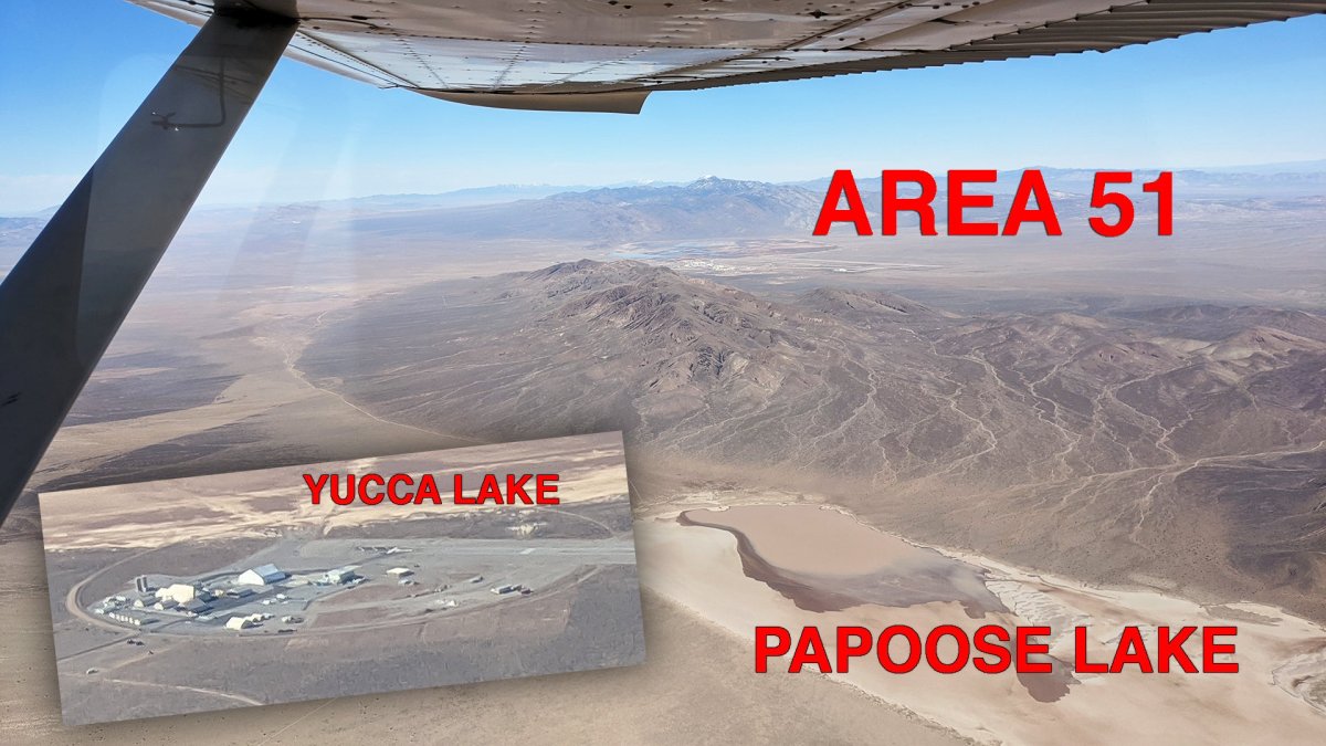
Below are shots of Papoose Lake with Area 51 just over the Papoose Mountain Range. Unsurprisingly, nothing appears to be there, just as satellite images show. There isn’t even an access road and, as you can see, the lakebed is flooded, which is a fairly common occurrence, making traversing it in a car or bus problematic. Regardless, it is a fun little pop-culture element to the story and for many, it will add to the evidence that Lazar’s story is a fake, albeit remarkably elaborate tale, and for the believers, it will probably do the opposite, somehow.
Lazar did play a huge part in turning Area 51 into a household name, for better or worse, and he did seem to know a lot about the base itself—the one that actually exists—for the pre-internet era. He has even made claims about seeing a high-speed exotic aircraft on the base while transiting to the remote UFO shop at S-4. Here is his drawing of that craft:
Bob’s drawing of what he thought was a methane-powered high-speed aircraft at Area 51. He claims the craft was ridiculously loud and had huge shutter-like square exhausts. , Bob Lazar via Jeremy Corbell
Although some of the details Bob mentioned about the base and its operations proved to be accurate, that doesn’t mean he worked on alien craft at some comic-book-like hideout facility built into the side of a mountain at Papoose Lake. The NTTR is a huge place, with big stakeholders like the Department of Energy and the Air Force operating an endless list of facilities out there, as you can see in these pictures. As such, it employs all the same types of people you would need for similar unsecured areas, including electricians, security personnel, janitors, cooks, engineers, computer techs, construction workers, and so on. So yes, you can work out there without reverse engineering UFOs or test-flying secret stealth aircraft.
After that little detour into the bizarre, we continue our flight…
An area of the Yucca Flat, north of Yucca Dry Lake, within the Nevada Test Site, now known as the Nevada National Security Site , which is heavily pockmarked from underground nuclear testing during the Cold War:
A view of the secretive airstrip at the southeastern edge of Yucca Dry Lake, within the Nevada National Security Site’s Area Six, that is used to support unmanned aircraft test and evaluation activities for the US military and other US government agencies, including the CIA. You can read our report on this facility here . You can also see the DOE’s fortress-like Device Assembly Facility to the far left.
You can see the big new semi-permanent hangar that has been erected on the facility’s main apron:
A view of Frenchman Dry Lake and the adjacent French Flat within the Nevada Test Site, which were the sites of numerous above-ground nuclear tests at the dawn of the nuclear era:
The view of the northern end of Dog Bone Lake, which sits in a part of the NTTR’s airspace designated R-4806W . The southern end of the lake bed serves as a gunnery and bombing range and has a MOUT facility that is regularly used for JTAC training , as well as other exercises where air and ground assets work together:
A view of the MOUT facility at Dog Bone Lake. , Gabriel Zeifman
Looking west at the very southern end of the NTTR. Creech Air Force Base is in the distance:
Our tour guide himself with Area 51 in the distance., Gabriel Zeifman
Here is our best approximation of where the images were taken:
Although we weren’t able to positively identify any secret UFO workshops hidden in mountainsides, these are some very rare images of an incredibly shy section of the American Southwest. A big thanks to Gabriel Zeifman once again for sharing the images from his airborne journey with us.
Contact the author: tyler@thedrive.com
Comments couldn’t be loaded. Please refresh the page.
更新于美国东部时间2020年4月13日晚上8:20
我们此前报道的私人飞行员加布里埃尔·泽夫曼(Gabriel Zeifman)令人叹为观止的内华达州试验训练靶场(NTTR)飞行经历,以及他飞越通常高度戒备的内华达州试验训练靶场的图集,吸引了全球读者的目光。该靶场包括一些神秘的基地,例如51区和托诺帕试验场机场,以及曾进行过数百次核武器试验的内华达州试验场。如今,加布里埃尔又分享了他在NTTR上空冒险的更多照片,这些照片本身就非常精彩,其中还包括我见过的关于UFO传说中一个热门地点——帕普斯湖(Papoose Lake)的最佳照片。帕普斯湖位于51区西南方向,鲍勃·拉扎尔(Bob Lazar)声称,他在20世纪80年代曾在一个名为S-4的伪装设施内逆向工程研究飞碟,该设施建在山体侧面。
不,我不相信鲍勃的故事,但我确实认为这是有史以来最引人入胜的故事之一,几十年来一直吸引着人们的想象。我写关于加布里埃尔飞行冒险的故事时,并没有想到鲍勃·拉扎尔或“S-4”,但文章发表后,我收到了大量电子邮件和私信,询问他是否有帕普斯湖的照片。除了卫星图像外,此前从未发现过该地区的直接照片,直到现在。
他穿越NTTR航线最令人印象深刻的部分是向西转弯,就在臭名昭著的、环绕着位于格鲁姆湖的秘密飞行试验设施的难以穿透的“盒子”空域的南侧。他飞行的这一部分直接带他飞向了
飞越帕普斯湖,以及拉扎尔曾声称为了躲避20世纪80年代的成像卫星技术而建在山坡侧面、伪装成机库大门的山丘。虽然加布里埃尔在我们上一篇文章中提到的那次飞行中没有拍摄到这一区域的照片,但他曾在之前的一次飞行中使用性能较差的相机拍摄过。
北部是格鲁姆湖和51区,南部是帕普斯湖。(谷歌地球)
为了保持连贯性,我们按照加布里埃尔在NTTR飞行过程中的轨迹,选取了一些他拍摄的图像进行展示。除了拉扎尔所谓的UFO逆向工程巢穴之外,还有更多值得一看的地方,包括位于能源部尤卡湖设施附近的另一个神秘基地。那个无人机测试基地拥有一个大型的新机库。我们还可以看到分布在NTTR中部和西南部不同靶场的各种目标,其中一个目标相当复杂。
我们的旅程将从内华达州利达枢纽附近开始,那里有一个湖床,上面画着巨大的幽默文字,供飞越的飞机阅读。然后,就像上次一样,加布里埃尔进入了通常封闭的空域——你可以在我们之前的文章中了解私人轻型飞机如何偶尔获得完全合法的准入——就在托诺帕试验场机场的北部。你已经看过他上次穿越该基地区域时拍摄的精彩照片——这里是F-117战斗机、美国秘密米格战机中队、RQ-170无人机以及其他未知装备的历史故乡。之后,他从那里下降到中央靶场区域,绕过51区,飞越帕普斯湖,进入这个庞大基地的南部区域。
说了这么多,我们开始吧:
在内华达州利达枢纽东北部的干涸湖床上,就在内华达州试验训练场(NTTR)的西缘,画出这个巨大的“UFO”和箭头的人,显然是想让路过的飞行员知道“真相就在那里”:
托诺帕试验场机场:
托诺帕试验场(TTR)全景。图中可见TTR内部的干涸湖泊轰炸靶场(曾用于测试惰性核弹)以及托诺帕试验场机场的生活设施。这些设施最初是为F-117项目而建,当时该项目在托诺帕秘密进行。
加布里埃尔的GPS显示他正在接近R-4808N禁区:
位于 NTTR 北部边缘 R-4807A 限制空域内的基诺简易机场,有时会被美国空军用于其“红旗”空中作战演习和联合强制进入演习 (JFEX):
基维奇谷的一个轰炸靶场,就在51区西北角以东:
另一个目标区域,代表一个机场,位于干涸湖床上的目标区域以南:
当加布里埃尔号飞越其封闭空域的北缘时,可以看到格鲁姆湖和位于那里的51区飞行测试中心:
加布里埃尔的飞机停在小外星人旅馆(Little A'Le'Inn)外的路边。这里是那些想要近距离接触51区的人经常出没的地方,它位于内华达州雷切尔镇的外星人高速公路(也称为内华达州375号公路)上。
下面这些照片展示了帕普斯湖,51区就在帕普斯山脉的另一侧。不出所料,正如卫星图像所示,那里空无一物。甚至连一条路都没有,而且正如你所看到的,湖床已被淹没,这种情况相当常见,使得驾车或乘坐巴士穿越湖面变得十分困难。尽管如此,这仍然是这个故事中一个有趣的流行文化元素,对许多人来说,这会进一步证明拉扎尔的故事是虚构的,尽管它编造得非常精妙;而对那些相信51区的人来说,这或许会起到相反的效果。
拉扎尔在将51区推向世界舞台的过程中扮演了举足轻重的角色,无论好坏。在互联网时代之前,他似乎对这个真实存在的基地了解颇多。他甚至声称,在前往S-4偏远UFO商店的途中,他曾在基地内看到过一架高速飞行的奇异飞行器。以下是他绘制的飞行器草图:
鲍勃画了一张他认为是51区一架甲烷动力高速飞行器的草图。他声称这架飞行器噪音极大,而且有巨大的方形百叶窗状排气口。(鲍勃·拉扎尔,图片来自杰里米·科贝尔)
虽然鲍勃提到的一些关于基地及其运作的细节后来被证实是准确的,但这并不意味着他真的在帕普斯湖附近某个像漫画书里描绘的那样,建在山腰上的秘密基地里研究外星飞船。正如你在这些照片中看到的,NTTR(国家测试试验场)规模庞大,能源部和空军等大型机构都在那里运营着数不胜数的设施。因此,它雇佣了所有类似非安全区域所需的人员,包括电工、保安、清洁工、厨师、工程师、计算机技术人员、建筑工人等等。所以,是的,你可以在那里工作,而无需逆向工程UFO或试飞秘密隐形飞机。
经历了这段奇特的小插曲后,我们继续飞行……
位于内华达试验场(现称为内华达国家安全基地)内,尤卡干湖以北的尤卡平原地区,因冷战期间的地下核试验而布满弹坑:
这是位于内华达州国家安全基地六区内,尤卡干湖东南边缘的一条秘密简易机场,用于支持美国军方和其他美国政府机构(包括中央情报局)的无人机测试和评估活动。您可以在这里阅读我们关于该设施的报道。您还可以看到位于最左侧的美国能源部堡垒般的设备组装设施。
您可以看到在机场主停机坪上新建的大型半永久性机库:
这是内华达试验场内弗伦奇曼干湖和邻近的弗伦奇平原的景色,这里在核时代初期曾进行过多次地面核试验:
这是狗骨湖的北端景色,该湖位于NTTR空域R-4806W区域内。湖床南端是炮兵和轰炸靶场,并设有城市作战训练设施,该设施经常用于联合终端攻击控制员(JTAC)训练以及其他空地协同作战演习:
狗骨湖作战训练设施一景。(摄影:加布里埃尔·泽夫曼)
从NTTR最南端向西望去,可以看到克里奇空军基地:
我们的导游加布里埃尔·泽夫曼,远处是51区。
以下是我们根据推测确定的图片拍摄地点:
虽然我们未能确凿地发现任何隐藏在山腰间的秘密UFO工作室,但这些照片展现了美国西南部一个极其隐秘的地区,非常罕见。再次衷心感谢加布里埃尔·泽夫曼与我们分享他空中拍摄的照片。
联系作者:tyler@thedrive.com
评论加载失败,请刷新页面。